Airborne hyperspectral study of spatial relationship between oil and gas leakage and salinization in Jimusar area
-
摘要:
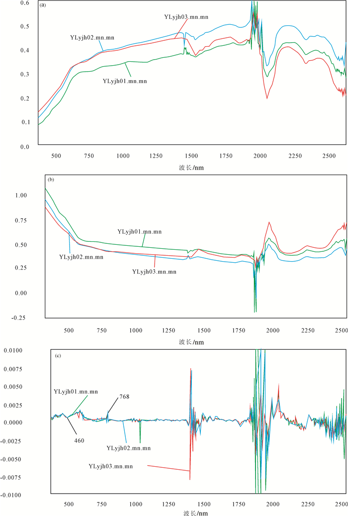
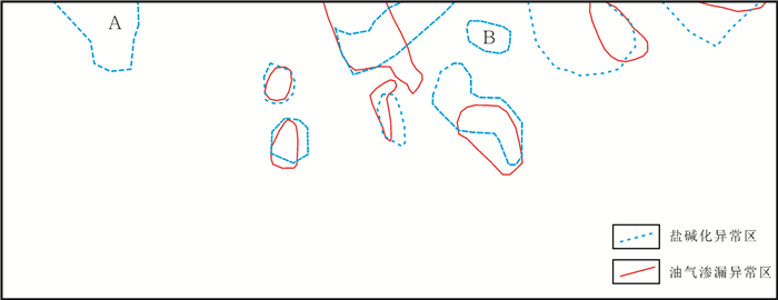
笔者在新疆吉木萨尔地区开展航空高光谱遥感油气探测示范研究的过程中,发现油气渗漏地区往往有盐碱化现象。据此,利用航空高光谱成像系统在该区取得的可见光-近红外和短波红外遥感数据,采用自主开发的波段分类填图方法,对吉木萨尔农田、荒地和戈壁地区的油气渗漏异常信息进行了提取,经野外验证和化学分析,圈定了7处油气渗漏异常区。同时,构建了盐碱化的高光谱识别模型,利用该模型进行了盐碱化信息填图,并对吉木萨尔同一覆盖区的盐碱化异常进行了提取,圈定了盐碱化异常区。通过对油气渗漏异常区与盐碱化异常区的叠置聚焦分析,发现二者空间位置有高度的重合性。笔者认为这一高光谱遥感探测发现,不仅具有探索的理论意义,而且具有实用价值。其实用价值主要体现在高光谱遥感油气探测中,通过烃碱信息的相互印证,可以减少油气信息的漏判,提高油气渗漏信息识别的准确性。同时,在缺少航空高光谱遥感数据的情况下,还可以利用卫星多光谱遥感数据源,通过提取盐碱化异常和圈定盐碱化异常区的途径,帮助缩小找油气的目标区,为油气资源的调查、评价和选区提供新的信息和依据。上述研究同时表明,自然界的盐碱化可能并非全是由"干旱蒸发"形成,很可能还存在与油气有关的盐碱化,在油气勘查中如何区分这两种类型的盐碱化,特别是应用高光谱遥感技术将二者区分开来,是值得深入探讨的科学问题。
-
关键词:
- 航空高光谱遥感 /
- CASI/SASI/TASI /
- 油气渗漏异常 /
- 盐碱化异常 /
- 烃碱聚焦
Abstract:Oil and gas leakages in the Jimusar area are spatially associated with salinization. In this study, the airborne hyperspectral image of the Jimusar region with a total area of 2500 km2 in Xinjiang was obtained by using CASI/SASI imagery of the National Key Laboratory of Science and Technology on Remote Sensing Information and Image analysis. The dataset was used to extract oil leakage information by using newly developed classification method. Seven oil leakage areas were detected. In addition, the extraction model for soil salt was also developed and applied to study the distribution of soil salt in the Jimasar region. Based on the superposition analysis of oil and gas anomaly area and salinization anomaly area, the authors detected a high degree of coincidence in the spatial location of the two ares. The authors believe that this hyperspectral remote sensing detection not only has theoretical significance but also has practical value. Its practical value is mainly reflected in the hyperspectral remote sensing oil and gas exploration. Through the mutual confirmation of hydrocarbon information, one can reduce redundant information of oil and gas leakage and improve the accuracy of oil and gas leakage identification. Additionally, in the absence of aerospace hyperspectral remote sensing data sources, satellite multispectral remote sensing data can also be used to extract the salinization anomalies and delineate the anomalous areas of salinization and alkalinization, thereby helping to narrow the target areas for oil and gas exploration. The results obtained by the authors indicate that the salinization of nature may not be wholly attributed to "dry evaporation", and there may be oil and gas related salinization. The distinguishing between these two kinds of salinization is a scientific problem worthy of in-depth discussion, especially in the field of hyperspectral remote sensing.
-
1. 引言
遥感地质找矿是遥感信息获取、含矿信息提取以及含矿信息成矿分析与应用的过程, 近年来, 被广泛应用于地质、矿产资源及相关环境的调查中(刘燕君等, 1993; 朱振海, 1994; 郭德方, 1995; Sabins, 1999; Everett et al., 2002; 廖崇高等, 2002; 连长云等, 2005; 刘颖璠等, 2012; 钱建平等, 2012; 谭克龙等, 2012; 杜小弟等, 2015)。航空高光谱是当前遥感的前沿技术, 通过高光谱成像所获取的地球表面的图像包含光谱维信息融合为一体, 即“图谱合一” (束炯等, 2006), 具有波段数多, 波带窄, 对地物能定量分析等优点, 是20世纪末期以来遥感领域最大的技术进展(Campbell et al., 2011)。航空高光谱遥感技术相对于星载高光谱遥感技术, 可以获取高空间分辨率的高光谱遥感数据, 因而对微小地物具有更强的识别能力(刘德长等, 2015)。通过高光谱矿物填图, 可以大面积、快速提取蚀变矿物(Clack et al., 1990)。王润生等(2010)系统总结了高光谱矿物填图技术流程、工作方法和技术体系。中国国土资源航空物探遥感中心在新疆土屋东—三岔口地区, 应用HyMap航空成像光谱数据填绘出了白云母、绿泥石、绿帘石、绿泥石和绿帘石组合、高岭石、蒙脱石、透辉石、透闪石、蛇纹石、褐铁矿、方解石等矿物或矿物组合种类(王润生等, 2011)。
本文以新疆卡拉塔格地区获取的HyMap航空高光谱数据、地面准同步定标数据、地面高光谱数据为例, 提取并筛选了基于HyMap航空高光谱影像的成矿有利蚀变信息, 在此基础上对红山铜金矿床航空-地面高光谱提取的蚀变信息进行了综合剖析, 并结合矿区地质背景, 建立了红山铜金矿床高光谱遥感地空综合找矿模型, 圈定了2处找矿有利地段。
2. 研究区地质概况
研究区大地构造位于东天山吐哈盆地南缘、大南湖—头苏泉晚古生代岛弧带(图 1)。
![]() 图 1 新疆卡拉塔格地区地质矿产图1—全新统:砂石及砾石沉积; 2—下侏罗统三工河组:粉砂质泥岩、泥质砂岩夹钙质砂岩; 3—上二叠统库莱组:砾岩、中粗粒岩屑砂岩; 4—中二叠统阿尔巴萨依组:凝灰岩、橄榄玄武岩; 5—上石炭统脐山组:玄武岩、安山岩; 6—下泥盆统大南湖组:安山岩、英安岩、熔结凝灰岩、火山角砾岩; 7—中—上志留统红柳峡组:凝灰质砾岩、晶屑岩屑凝灰岩; 8—中奥陶统荒草坡群大柳沟组:玄武岩、安山岩、英安岩; 9—志留纪二长花岗岩; 10—志留纪花岗闪长岩; 11—志留纪英云闪长岩; 12—花岗岩体; 13—地质界线; 14—角度不整合界线; 15—岩相界线; 16—逆断层; 17—性质不明断层; 18—推测断层; 19—铜金矿; 20—铜锌矿; 21—铜锌金矿; 22—铜铁矿Figure 1. Geological map of Kalatag area in Xinjiang1-Holocene, sand and gravel deposits; 2-Lower Jurassic Sangonghe Formation: river silty mudstone, argillaceous sandstone intercalated with calcareous sandstone; 3-Permian Kulai Formation: breccia, coarse grained lithic sandstone; 4-Middle Permian Aebasayi Formation: tuff, olivine basalt; 5-Carboniferous Qishan Formation: basalt, andesite; 6-Lower Devonian Dananhu Formation: andesite, dacite, welded tuff and volcanic breccia; 7-Middle-upper Silurian Hongliuxia Formation: tuffaceous conglomerate, wafer crumbs debris tuff; 8-Daliugou Formation of Ordovician Huangcaopo Group: basalt, andesite, dacite; 9-Silurian monzonitic granite; 10-Silurian granite diorite; 11-Silurian tonalite; 12-Granite rock mass; 13-Geological boundary; 14-Angular unconformity; 15-Petrofacies boundary; 16-Thrust; 17-Unknown fault; 18-Inferred fault; 19-Copper and gold deposit; 20-Copper and zinc deposit; 21-Copper zinc deposit; 22-copper deposit
图 1 新疆卡拉塔格地区地质矿产图1—全新统:砂石及砾石沉积; 2—下侏罗统三工河组:粉砂质泥岩、泥质砂岩夹钙质砂岩; 3—上二叠统库莱组:砾岩、中粗粒岩屑砂岩; 4—中二叠统阿尔巴萨依组:凝灰岩、橄榄玄武岩; 5—上石炭统脐山组:玄武岩、安山岩; 6—下泥盆统大南湖组:安山岩、英安岩、熔结凝灰岩、火山角砾岩; 7—中—上志留统红柳峡组:凝灰质砾岩、晶屑岩屑凝灰岩; 8—中奥陶统荒草坡群大柳沟组:玄武岩、安山岩、英安岩; 9—志留纪二长花岗岩; 10—志留纪花岗闪长岩; 11—志留纪英云闪长岩; 12—花岗岩体; 13—地质界线; 14—角度不整合界线; 15—岩相界线; 16—逆断层; 17—性质不明断层; 18—推测断层; 19—铜金矿; 20—铜锌矿; 21—铜锌金矿; 22—铜铁矿Figure 1. Geological map of Kalatag area in Xinjiang1-Holocene, sand and gravel deposits; 2-Lower Jurassic Sangonghe Formation: river silty mudstone, argillaceous sandstone intercalated with calcareous sandstone; 3-Permian Kulai Formation: breccia, coarse grained lithic sandstone; 4-Middle Permian Aebasayi Formation: tuff, olivine basalt; 5-Carboniferous Qishan Formation: basalt, andesite; 6-Lower Devonian Dananhu Formation: andesite, dacite, welded tuff and volcanic breccia; 7-Middle-upper Silurian Hongliuxia Formation: tuffaceous conglomerate, wafer crumbs debris tuff; 8-Daliugou Formation of Ordovician Huangcaopo Group: basalt, andesite, dacite; 9-Silurian monzonitic granite; 10-Silurian granite diorite; 11-Silurian tonalite; 12-Granite rock mass; 13-Geological boundary; 14-Angular unconformity; 15-Petrofacies boundary; 16-Thrust; 17-Unknown fault; 18-Inferred fault; 19-Copper and gold deposit; 20-Copper and zinc deposit; 21-Copper zinc deposit; 22-copper deposit区内地层整体呈北西向产出, 由中奥陶统荒草坡群大柳沟组(O2Hd)、中—上志留统红柳峡组(S2-3h)、下泥盆统大南湖组(D1d)、上石炭统脐山组(C2qs)、中二叠统阿尔巴萨依组(P2a)、上二叠统库莱组(P3k)、下侏罗统三工河组(J1s)、全新统(Qh)组成。
该区经历了多期次的构造变动, 区域构造形成类型多样、特征复杂, 褶皱、断裂和火山机构发育, 区域性的断裂构造控制着该区火山岩和侵入岩的展布, 次级断裂控制着矿化蚀变带的分布, 更次一级构造裂隙带控制着矿化体的产出。主要发育北西、北北西和北东东向三组断裂构造, 其中北西向断裂为该区主要控矿构造, 同火山断裂发育, 含矿火山热液沿断裂活动强烈。
区内火山活动强烈, 火山岩分布广泛。岩石类型以中基性火山岩为主, 中酸性火山岩次之, 从奥陶系至二叠系均有出露, 其中奥陶系最为发育, 其次为泥盆系、石炭系, 二叠系局部出现。侵入岩较为发育, 主要为一套古生代侵入体, 包括中酸性闪长岩、花岗闪长岩、花岗岩等侵入岩, 中部为与铜金矿化直接相关的中生代中酸性火山机构, 主要由石英斑岩、钠长斑岩、英安岩、英安斑岩、安山玢岩、闪长玢岩和火山角砾集块岩等岩性构成。其中志留纪侵入岩由老到新依次为英云闪长岩、花岗闪长岩、二长花岗岩、花岗斑岩。该区经受了区域埋深变质作用, 变质程度较弱, 主要变质矿物为绿泥石、钠长石、葡萄石、石英、阳起石、方解石、绿帘石。
区内已知矿床自北西向南东依次产出有:红山铜金矿床→梅岭铜锌金矿床→红石铜金矿床→红海铜锌金矿床。
3. 高光谱遥感地空综合预测方法用于寻找铜金矿床的原理
3.1 高光谱遥感地空综合预测方法的依据
不同矿床类型由于岩石岩性和蚀变矿物不同, 它们的光谱特征有明显的差异(姚佛军, 2006)。铜金矿床属于内生金属矿床, 这类矿床与地表蚀变密切相关, 可以利用航空高光谱遥感影像进行蚀变矿物提取, 结合地表岩石光谱测试分析, 应用HyMap航空成像光谱仪和美国ASD公司的FieldSpec Pro FR光谱仪对不同类型矿床的光谱特征进行测量, 分析其不同类型矿床的光谱特征, 进行蚀变矿物遥感信息提取, 开展高光谱遥感地空综合预测研究, 进而指导找矿。
3.2 蚀变矿物诊断性光谱特征分析
岩矿的光谱包含有一系列特征吸收谱带。每一个特征谱带或谱带组合与岩矿内部微粒的物质属性存在一定的对应关系(Povarennykh, 1978)。在短波红外光谱区域, 褐铁矿、黄钾铁矾、白云母、绿泥石等具有可以识别的诊断性光谱特征, 特征吸收波段的深度与岩石中这些矿物的含量密切相关(刘圣伟, 2006)。矿物诊断性光谱吸收包括金属阳离子在可见光区域的电子过程以及阴离子基团在近红外区域的振动过程。蚀变矿物的可见光−近红外范围内几种官能团主要包括Fe2+、Fe3+、Al−OH、Mg−OH、OH-、CO32-。
一般阴离子诊断谱带位于2000~2500 nm光谱区域。而Fe2+、Fe3+和Mn2+诊断谱带一般位于400~1200 nm光谱区域(甘甫平等, 2003)。所以根据400~1100 nm光谱区间的Fe吸收谱带和2000~2500 nm羟基和碳酸根谱带将矿物分为含铁矿物、含羟基矿物和含碳酸根矿物以及其他矿物(甘甫平, 2003)。褐铁矿的光谱吸收谷是矿物光谱分析、遥感铁染异常提取常用的波段。其中Fe3+离子的特征吸收谷位主要在600~800 nm, 中心位置在700 nm左右, Fe2+离子的特征吸收谷位主要在900~1500 nm, 中心位置在1200 nm左右; 白云母的诊断性光谱特征是Al−OH键在2180~2230 nm之间的尖锐而深的吸收特征, 以及在2340 nm和2440 nm附近的较弱Al−OH特征, Clark et al.(1990)在高光谱分辨率下, 检测到白云母矿物在2200 nm附近的吸收波段随Al含量的增加向长波方向的移动; 绿泥石的光谱具有Fe−OH和Mg−OH的诊断性吸收特征, 波长位置分别为2235~2255 nm和2320~2360 nm, 这些吸收特征的波长随着绿泥石中铁离子含量的增加而增大。
4. HyMap航空高光谱数据获取及处理
综合考虑仪器参数、成图精度的要求、研究区自然地理、地形起伏、野外工作条件等因素, 进行飞行方案的最优设计(表 1)。将HyMap成像光谱仪搭载在Y−12飞机上, 利用国外引进的HyMap航空高光谱遥感测量系统、地面ASD光谱测量系统。采集高光谱分辨率的HyMap航空高光谱遥感数据、地面准同步的地物光谱定标数据。具体获取过程分为3个步骤:首先对HyMap成像光谱仪进行实验室定标, 保证其性能指标达到项目要求, 以获取优质的高光谱影像数据; 其次进行HyMap仪器的安装和测试, 按照仪器安装规范方法, 将HyMap安装在Y−12飞机上, 保证机下的摄影窗口满足数据获取要求, 按照航空成像光谱数据获取规范进行地面测试; 最后为HyMap航空高光谱数据获取和初步质量检查。
表 1 HyMap航空成像光谱仪主要技术参数Table 1. Main technical parameters of HyMap aviation imaging spectroradiometer
在此基础上, 开展HyMap航空高光谱遥感数据辐射定标、大气校正光谱反演、几何校正和地理编码等数据处理工作。通过此项研究, 为高光谱遥感地空综合预测铜金矿床的技术方法研究和应用提供可靠的数据基础。
5. 地面高光谱数据获取及处理
地面光谱测量采用美国ASD公司生产的FieldSpec Pro FR地面光谱测量仪(表 2)。利用该仪器开展了地面光谱准同步定标。在HyMap高光谱数据获取过程中, 准同步布设黑白布定标场和明暗地物定标场, 利用FieldSpec Pro FR地面光谱测量仪进行光谱定标数据获取(图 2,图 3), 并基于经验线性模型法, 对高光谱影像进行大气校正和光谱比对分析。
表 2 FieldSpec Pro FR光谱仪主要技术参数Table 2. Main technical parameters of FieldSpec Pro FR spectrometer
同时开展了典型铜金矿床地表蚀变围岩和其他相关的岩石地物的光谱测量, 完成了4条贯穿地层走向的成矿有利地质单元光谱测量和4条典型矿床光谱测量。共完成光谱测量点287个, 光谱测量曲线2870条。测量完成后, 开展了各岩石类型的岩矿光谱数据处理、光谱库建立、光谱特征分析等研究工作, 研究及分析结果为航空高光谱蚀变矿物信息提取、地面光谱验证、铜金矿床围岩蚀变信息筛选等提供重要的地面光谱信息支持。
地面高光谱数据处理采用ViewSpec Pro软件, 利用ViewSpec Pro软件挑选符合要求的地面岩矿光谱曲线, 并将这些曲线转换为txt格式的文件。由于受到太阳位置、角度条件、大气条件、地形影响及传感器本身性能的影响, 传感器所记录的数据与目标的光谱反射率或光谱辐射亮度值并不一致。需先将传感器记录的原始辐射值(DN值)转化为地物反射率(李志忠等, 2015)。
6. 蚀变矿物信息提取处理方法及分布特征
目前基于高光谱遥感影像数据提取矿物的处理方法可以分为2类: (1)通过像元光谱与矿物标准光谱曲线的匹配实现识别和量化目标矿物; (2)提取矿物光谱特征吸收波段参数作为识别和量化指标(卢燕, 2014)。前者在处理过程中光谱数据信息可能由于重定标而部分丢失。且基于单幅图像统计参数的处理方法难以做到无缝衔接, 该方法也涉及大量的运算。本次研究区蚀变矿物提取主要基于第2种方法。该方法利用ENVI软件, 基于可编程实现的特征提取处理通道, 该通道中脚本设计是基于提取光谱参数, 首先对影像光谱数据进行均值标准化、去连续统、卷积平滑等数据预处理, 在进行特征深度、特征面积、特征宽度、极小值波长、比值、算术和逻辑运算等特征参数提取。同时利用多个诊断性特征来标记或约束特定的矿物, 提取矿物的分布和相对含量, 并增强矿物识别的精度。
根据矿物光谱特征吸收波段参数的蚀变矿物提取方法, 在研究区提取了褐铁矿−黄钾铁矾、白云母−蒙脱石、绿泥石−绿帘石−碳酸盐、叶腊石等蚀变矿物或组合(图 4), 其中褐铁矿−黄钾铁矾、白云母−蒙脱石、绿泥石−绿帘石−碳酸盐等蚀变矿物组合在全区范围内分布, 且呈团块状、条带状及星散状。叶腊石则仅在研究区北东部呈星点状分布, 蚀变不明显, 对于指导找矿意义不大(黄色圈内为叶腊石分布位置)。
![]() 图 4 新疆卡拉塔格地区HyMap航空高光谱蚀变矿物丰度图a—褐铁矿-黄钾铁矾; b—白云母-蒙脱石; c—绿泥石、绿帘石、碳酸盐; d—叶腊石, 黄色圈内为叶腊石分布位置Figure 4. HyMap aviation hyperspectral alteration mineral abundance map of Kalatag area in Xinjianga-Limonite-jarosite; b-Muscovite-montmorillonite; c-Chlorite, epidote, carbonate; d-Pyrophyllite, yellow circle indicates pyrophyllite distribution position
图 4 新疆卡拉塔格地区HyMap航空高光谱蚀变矿物丰度图a—褐铁矿-黄钾铁矾; b—白云母-蒙脱石; c—绿泥石、绿帘石、碳酸盐; d—叶腊石, 黄色圈内为叶腊石分布位置Figure 4. HyMap aviation hyperspectral alteration mineral abundance map of Kalatag area in Xinjianga-Limonite-jarosite; b-Muscovite-montmorillonite; c-Chlorite, epidote, carbonate; d-Pyrophyllite, yellow circle indicates pyrophyllite distribution position7. 红山铜金矿床高光谱遥感地空综合找矿模型的建立与找矿有利地段优选
7.1 矿区地质特征
红山铜金矿床是高硫型−浅成低温热液型矿床(董承维, 2013)。矿床产于陆相蚀变酸性火山穹窿及其通道中, 该次火山机构受近东西与北西向两组断裂控制, 且主要控岩控矿构造为北西向断裂。铜矿体受北西向断裂及其次级构造破碎带控制, 为浸染状辉铜矿化和黄铜矿化。金矿化主要与酸性次火山岩中的细粒黄铁矿有关(王瑞军等, 2014) (图 5)。
![]() 图 5 红山铜金矿区地质图(据王京彬, 2006)1—第四系残坡积物、风积物; 2—英安岩、英安斑岩、安山岩; 3—蚀变英安岩; 4—流纹斑岩、石英斑岩、霏细斑岩; 5—花岗岩; 6—花岗闪长岩脉; 7—闪长玢岩脉; 8—氧化带矿体; 9—推测断层; 10—片理化带; 11—金矿体; 12—铜矿体Figure 5. Geological map of the Hongshan Cu-Au deposit (after Wang, 2006)1-quaternary debris slope sediments, aeolian; 2-dacite, British Ann porphyry, andesite; 3-alteration dacite; 4-rhyolitic porphyry and quartz porphyry, faye fine porphyry; 5-granite; 6-granite diorite vein; 7-diorite Bin dike; 8-oxidation zone ore body; 9-speculation fault; 10-piece of physics and chemistry; 11-gold ore body; 12-copper ore body
图 5 红山铜金矿区地质图(据王京彬, 2006)1—第四系残坡积物、风积物; 2—英安岩、英安斑岩、安山岩; 3—蚀变英安岩; 4—流纹斑岩、石英斑岩、霏细斑岩; 5—花岗岩; 6—花岗闪长岩脉; 7—闪长玢岩脉; 8—氧化带矿体; 9—推测断层; 10—片理化带; 11—金矿体; 12—铜矿体Figure 5. Geological map of the Hongshan Cu-Au deposit (after Wang, 2006)1-quaternary debris slope sediments, aeolian; 2-dacite, British Ann porphyry, andesite; 3-alteration dacite; 4-rhyolitic porphyry and quartz porphyry, faye fine porphyry; 5-granite; 6-granite diorite vein; 7-diorite Bin dike; 8-oxidation zone ore body; 9-speculation fault; 10-piece of physics and chemistry; 11-gold ore body; 12-copper ore body矿区地表发育黄钾铁钒化、绢云母化、硅化、褐铁矿化、黄铁矿化、绿泥石化、绿帘石化、青磐岩化。近矿蚀变以火山岩酸淋滤带蚀变体的黄钾铁矾化−明矾石化−高岭土化−石膏和中性斑岩体的绢云母化−硅化为显著特征, 远矿蚀变为青磐岩化(许英霞等, 2008)。矿区中心为泥化、硫酸盐带, 向北为硅化−伊利石化−绢云母化−褐铁矿化带。具有找矿标志的矿化蚀变为:硅化−绢云母化、伊利石化、褐铁矿化、硅化、高岭土化−明矾石化等。
红山铜金矿床矿化以铜、金矿为主, 赋矿岩性主要为流纹岩、英安岩、安山玢岩、闪长玢岩、火山角砾岩。矿石矿物主要为黄铜矿、蓝铜矿、闪锌矿、磁铁矿、赤铁矿、黄钾铁钒等。脉石矿物为石英、斜长石、绢云母、绿泥石等。矿石呈稠密浸染状、细脉状、角砾状构造(许英霞, 2010)。
7.2 红山铜金矿床高光谱遥感地空综合找矿模型的建立
充分研究区域成矿有利的构造、地层、岩浆岩条件、变质条件的基础上, 结合区域控矿因素、矿床、矿化蚀变特征, 进行航空高光谱蚀变矿物分布特征分析及评价。本文截取了研究区内红山铜金矿床及外围基于HyMap航空高光谱遥感影像的蚀变矿物分布图(图 6), 图中显示红山铜金矿床中心位置处于开采状态, 呈黑白相间且颜色突变的色调, 影纹粗糙且不均匀, 矿床外围呈灰黑色、灰绿色色调, 影纹粗糙。与矿床有关的航空高光谱蚀变矿物组合主要为褐铁矿+黄钾铁钒、绢云母+蒙脱石等, 呈大面积的团块状分布。在矿床外围分布着呈星散状、星点状的绿泥石+绿帘石蚀变矿物组合, 该组蚀变为铜金矿床外围主要发育的蚀变组合, 对于寻找该类型矿床有一定的指示作用。
在红山铜金矿区收集了具体的剖线采样和光谱数据, 图 7为红山铜金矿区的地质光谱综合剖面, 出露的地层为中奥陶统荒草坡群大柳沟组, 岩性主要为英安岩、片理化带、流纹斑岩、花岗岩、花岗闪长岩、构造蚀变岩以及铜金矿化体等。蚀变矿物主要有褐铁矿、黄钾铁钒、绢云母、石膏、高岭石、明矾石及方解石等。通过样品采集和光谱测试结果, 研究与该区铜金矿关系密切的几种赋矿岩性的光谱曲线, 分别为构造蚀变岩、花岗闪长岩、花岗岩、流纹斑岩、蚀变英安岩、及铜金矿化体。
![]() 图 7 红山铜金矿区剖线地面高光谱蚀变矿物分布图1—英安岩; 2—片理化带; 3—流纹斑岩; 4—花岗岩; 5—花岗闪长岩; 6—断裂构造; 7—地面光谱样采样点; 8—地面光谱测试点编号; 9—褐铁矿; 10—黄钾铁矾; 11—绢云母; 12—石膏; 13—高岭石; 14—明矾石; 15—方解石Figure 7. Surface hyperspectral alteration mineral distribution along geological section in the Hongshan copper gold orefield1-Dacite; 2-Schistosity zone; 3-Rhyolitic porphyry; 4-Granite; 5-Granite diorite; 6-Fracture structure; 7-Surface spectrum sampling site; 8-Serial number of spectrum test point; 9-Limonite; 10-Jarosite; 11-Sericite; 12-Gypsum; 13-Kaolinite; 14-Alunite; 15-Calcite
图 7 红山铜金矿区剖线地面高光谱蚀变矿物分布图1—英安岩; 2—片理化带; 3—流纹斑岩; 4—花岗岩; 5—花岗闪长岩; 6—断裂构造; 7—地面光谱样采样点; 8—地面光谱测试点编号; 9—褐铁矿; 10—黄钾铁矾; 11—绢云母; 12—石膏; 13—高岭石; 14—明矾石; 15—方解石Figure 7. Surface hyperspectral alteration mineral distribution along geological section in the Hongshan copper gold orefield1-Dacite; 2-Schistosity zone; 3-Rhyolitic porphyry; 4-Granite; 5-Granite diorite; 6-Fracture structure; 7-Surface spectrum sampling site; 8-Serial number of spectrum test point; 9-Limonite; 10-Jarosite; 11-Sericite; 12-Gypsum; 13-Kaolinite; 14-Alunite; 15-Calcite经研究分析发现:红山铜金矿床及外围不同岩性地面光谱特征各不相同, 各类岩性具体曲线(图 8)特征如下:
![]() 图 8 红山铜金矿床及外围各岩性光谱曲线对比图a—构造蚀变岩; b—花岗闪长岩; c—花岗岩; d—流纹斑岩; e—蚀变英安岩; f—铜金矿化体Figure 8. Comparison diagram of various lithology spectral curves from the Hongshan copper gold deposit and peripheral areasa-Tectonic altered rock; b-Granodiorite; c-Granite; d-Rhyolitic porphyry; e-Altered dacite; f-Copper gold mineralization body
图 8 红山铜金矿床及外围各岩性光谱曲线对比图a—构造蚀变岩; b—花岗闪长岩; c—花岗岩; d—流纹斑岩; e—蚀变英安岩; f—铜金矿化体Figure 8. Comparison diagram of various lithology spectral curves from the Hongshan copper gold deposit and peripheral areasa-Tectonic altered rock; b-Granodiorite; c-Granite; d-Rhyolitic porphyry; e-Altered dacite; f-Copper gold mineralization body构造蚀变岩(图 8-a)地面光谱曲线特征显示: 880 nm处的Fe3+特征吸收可能为褐铁矿化所致; 2210 nm处的弱吸收峰为发育弱绢云母化所致, 2260 nm处的较强吸收峰为岩石发育黄钾铁矾化所致。故构造蚀变岩蚀变矿物组合为:褐铁矿+黄钾铁矾+绢云母。
花岗闪长岩(图 8-b)地面光谱曲线特征显示: 880 nm处较强的对称吸收峰为岩石发育褐铁矿化所致; 2210 nm处较强的吸收峰, 及右肩2250 nm处较弱次级吸收峰, 是Al−OH的特征吸收, 为明矾石化所致; 2350 nm处强的主吸收峰, 左肩2250 nm处较强的次级吸收峰, 是Mg−OH的特征吸收, 为绿泥石化所致。故其蚀变矿物组合为:褐铁矿+明矾石+绿泥石。
花岗岩(图 8-c)地面光谱曲线特征显示: 910 nm处较弱的Fe3+特征吸收峰为褐铁矿化所致; 2210 nm处的弱Al−OH特征吸收峰为绢云母化引起, 其右肩2250 nm处的较弱吸收峰可能为明矾石化所致; 2265 nm处的较弱吸收峰可能为黄钾铁矾化所致; 2330 nm处可见较强吸收峰, 是CO32-的特征吸收峰, 为岩石发育碳酸盐化所致, 故花岗岩蚀变矿物组合为:褐铁矿+黄钾铁矾+绢云母+明矾石+方解石。
流纹斑岩(图 8-d)地面光谱曲线特征显示: 880 nm处的较强吸收峰为褐铁矿化所致; 2210 nm处的强Al−OH特征吸收峰为岩石发育绢云母化所致; 2265 nm处的弱Fe−OH特征吸收峰为岩石发育黄钾铁矾化所致, 故流纹斑岩蚀变矿物组合为:褐铁矿+黄钾铁钒+绢云母。
蚀变英安岩(图 8-e)地面光谱曲线特征显示: 880 nm处的弱吸收峰为弱褐铁矿化所致; 2210 nm处的弱Al−OH特征吸收峰为绢云母化引起; 2350 nm处的较强主吸收峰及其左肩2250 nm处的较强次级吸收峰, 是Mg−OH的特征吸收峰, 为绿泥石化所致; 2330 nm处的较强主吸收峰以及1880 nm、2060 nm、2170 nm处较弱次级吸收峰, 是CO32-的特征吸收峰, 为岩石发育碳酸盐化所致; 1836 nm、1935 nm、2213 nm、2270 nm处可见多处较强吸收峰, 为岩石发育石膏所致。故蚀变英安岩蚀变矿物组合为:褐铁矿+绢云母+绿泥石+方解石+石膏。
铜金矿化体(图 8-f)地面光谱曲线特征显示: 880 nm处的较强Fe3+特征吸收为岩石发育褐铁矿化所致; 2210 nm处的弱Al−OH特征吸收峰为岩石发育绢云母化; 2265 nm处的弱Fe−OH特征吸收峰为岩石发育黄钾铁矾化; 1540 nm、1835 nm、1920 nm、2000 nm、2165 nm、2208 nm、2250 nm、2329 nm、2374 nm、2385 nm处可见多处较强吸收峰, 可能为岩石发育黝帘石化所致。故铜金矿化体蚀变矿物组合为:褐铁矿+绢云母+黄钾铁钒+黝帘石。
根据航空高光谱和地面高光谱蚀变矿物或组合的类型和分布特征, 结合红山铜金矿床的地质特征, 进行典型矿床航空−地面高光谱综合剖析, 最终建立了红山铜金矿床高光谱遥感地空综合找矿模型(表 3)。
表 3 红山铜金矿床高光谱遥感地空综合找矿模型Table 3. Hyperspectral remote sensing air comprehensive prospecting model for the Hongshan copper gold deposit
7.3 铜金矿床找矿有利地段优选
在建立红山铜金矿床高光谱遥感地空综合找矿模型的基础上, 结合地质、野外调查验证等多源地学信息, 运用高光谱遥感地空综合预测方法, 优选了2处与已知矿床航空−地面高光谱向类似的找矿有利地段, 分别为I−1和I−2(图 9)。
![]() 图 9 新疆卡拉塔格地区找矿有利地段优选图1—全新统:砂石及砾石沉积; 2—下侏罗统三工河组:粉砂质泥岩、泥质砂岩夹钙质砂岩; 3—上二叠统库莱组:砾岩、中粗粒岩屑砂岩; 4—中二叠统阿尔巴萨依组:凝灰岩、橄榄玄武岩; 5—上石炭统脐山组:玄武岩、安山岩; 6—下泥盆统大南湖组:安山岩、英安岩、熔结凝灰岩、火山角砾岩; 7—中-上志留统红柳峡组:凝灰质砾岩、晶屑岩屑凝灰岩; 8—中奥陶统荒草坡群大柳沟组:玄武岩、安山岩、英安岩; 9—志留纪二长花岗岩; 10—志留纪花岗闪长岩; 11—志留纪英云闪长岩; 12—花岗岩体; 13—地质界线; 14—角度不整合界线; 15—岩相界线; 16—逆断层; 17—性质不明断层; 18—推测断层; 19—铜金矿; 20—铜锌矿; 21—铜锌金矿; 22—铜铁矿; 23—高光谱找矿有利地段Figure 9. Favorable ore-prospecting optimization segments in Kalatag area of Xinjiang1-Holocene, sand and gravel deposits; 2-Lower Jurassic Sangonghe Formation: river silty mudstone, argillaceous sandstone intercalated with calcareous sandstone; 3-Permian Kulai Formation: breccia, coarse grained lithic sandstone; 4-Middle Permian Aebasayi Formation: tuff, olivine basalt; 5-Carboniferous Qishan Formation: basalt, andesite; 6-Lower Devonian Dananhu Formation: andesite, dacite, welded tuff and volcanic breccia; 7-Middle-upper Silurian Hongliuxia Formation: tuffaceous conglomerate, wafer crumbs debris tuff; 8-Daliugou Formation of Ordovician Huangcaopo Group: basalt, andesite, dacite; 9-Silurian monzonitic granite; 10-Silurian granite diorite; 11-Silurian tonalite; 12-Granite rock mass; 13-Geological boundary; 14-Angular unconformity; 15-Petrofacies boundary; 16-Thrust; 17-Unknown fault; 18-Inferred fault; 19-Copper and gold deposit; 20-Copper and zinc deposit; 21-Copper zinc deposit; 22-copper deposit; 23-Hyperspectral favorable ore-prospecting segments
图 9 新疆卡拉塔格地区找矿有利地段优选图1—全新统:砂石及砾石沉积; 2—下侏罗统三工河组:粉砂质泥岩、泥质砂岩夹钙质砂岩; 3—上二叠统库莱组:砾岩、中粗粒岩屑砂岩; 4—中二叠统阿尔巴萨依组:凝灰岩、橄榄玄武岩; 5—上石炭统脐山组:玄武岩、安山岩; 6—下泥盆统大南湖组:安山岩、英安岩、熔结凝灰岩、火山角砾岩; 7—中-上志留统红柳峡组:凝灰质砾岩、晶屑岩屑凝灰岩; 8—中奥陶统荒草坡群大柳沟组:玄武岩、安山岩、英安岩; 9—志留纪二长花岗岩; 10—志留纪花岗闪长岩; 11—志留纪英云闪长岩; 12—花岗岩体; 13—地质界线; 14—角度不整合界线; 15—岩相界线; 16—逆断层; 17—性质不明断层; 18—推测断层; 19—铜金矿; 20—铜锌矿; 21—铜锌金矿; 22—铜铁矿; 23—高光谱找矿有利地段Figure 9. Favorable ore-prospecting optimization segments in Kalatag area of Xinjiang1-Holocene, sand and gravel deposits; 2-Lower Jurassic Sangonghe Formation: river silty mudstone, argillaceous sandstone intercalated with calcareous sandstone; 3-Permian Kulai Formation: breccia, coarse grained lithic sandstone; 4-Middle Permian Aebasayi Formation: tuff, olivine basalt; 5-Carboniferous Qishan Formation: basalt, andesite; 6-Lower Devonian Dananhu Formation: andesite, dacite, welded tuff and volcanic breccia; 7-Middle-upper Silurian Hongliuxia Formation: tuffaceous conglomerate, wafer crumbs debris tuff; 8-Daliugou Formation of Ordovician Huangcaopo Group: basalt, andesite, dacite; 9-Silurian monzonitic granite; 10-Silurian granite diorite; 11-Silurian tonalite; 12-Granite rock mass; 13-Geological boundary; 14-Angular unconformity; 15-Petrofacies boundary; 16-Thrust; 17-Unknown fault; 18-Inferred fault; 19-Copper and gold deposit; 20-Copper and zinc deposit; 21-Copper zinc deposit; 22-copper deposit; 23-Hyperspectral favorable ore-prospecting segmentsI−1找矿有利地段分布在玉带铜金矿点北西侧一带, 呈北北西向展布, 面积约5.2 km2。区内分布的地层为中−上志留统红柳峡组(S2-3h)火山岩, 近东西向断裂构造发育, 区内多发育褐铁矿化、硅化、绿帘石化等蚀变。微量元素分析23个, 化学分析显示钛含量最高达0.23×10⁻², 金红石含量最高达0.38×10⁻²。为铜、金、钛等元素多金属找矿有利地段(图 10)。
I−2找矿有利地段分布在东二区南东侧, 呈近东西向展布, 面积约6.8 km2。区内分布的地层为中奥陶统荒草坡群大柳沟组(O2Hd)火山岩, 北东东向断裂构造发育, 花岗闪长岩体呈近东西向展布, 区内多发育硅化、褐铁矿化、赤铁矿化、绿帘石化、孔雀石化等蚀变。微量元素分析15个, 化学分析显示钛元素含量最高达0.21×10⁻², 金红石含量最高达0.35×10⁻², 且区内已有红山铜金矿床分布, 为铜、金、钛等元素多金属找矿有利地段(图 11)。
8. 结论
(1) 新疆东天山卡拉塔格铜金多金属矿床集中, 地表具有指示意义的蚀变矿物分布较为典型, 适合利用高光谱遥感地空综合预测方法在该区寻找铜金及多金属矿床, 故该方法为寻找铜金矿床的有效技术方法。
(2) 在运用HyMap航空成像光谱仪和FieldSpec Pro FR光谱仪进行高光谱数据获取和处理的基础上, 结合HyMap航空高光谱蚀变矿物提取效果分析, 最终开展典型矿床航空−地面高光谱综合剖析研究, 建立了红山铜金矿床高光谱遥感地空综合找矿模型, 并综合地质、野外调查验证等多源地学信息, 圈定了I−1和I−2等两处找矿有利地段。
(3) 与常规的地质、区域化探等地质矿产勘查方法相比, 高光谱遥感地空综合预测方法具有低成本、快速高效的优势。但由于各类矿床的找矿标志和高光谱异常信息多种多样, 从而造成蚀变异常信息的多解性, 加上利用高光谱地空综合预测方法开展多金属矿产资源调查研究还比较少, 需要今后继续完善成熟。
致谢: 感谢李志忠、翟刚毅、杜小弟等对该项研究工作给予的大力支持。 -
表 1 CASI/SASI/TASI高光谱成像仪技术参数
Table 1 Technical features of CASI/SASI/TASI system

-
Campbell J B, Wynne R H. 2011. Introduction to Remote Sensing. Fifth Edition[M]. New York:Guilford Press, 3-28.
Clark R N, King T V V, Klejwa M, Swayze G A, Vergo N. 1990. High spectral resolution reflectance spectroscopy of minerals[J]. Journal of Geophysical Research, 95:12653-12680. doi: 10.1029/JB095iB08p12653
Du Letian. 1996. Hydrocarbon Alkali Fluid geochemistry-new Discussion on Hydrothermal Fluids and Magma Process[M]. Beijing:Science Press, 140-176.
Du Xiaodi, Tang Yue, Liu Dechang, Li Zhao, Wang Haida. 2015. The application of aerial hyperspectral technology to the geological survey for oil and gas in the East Junggar Bain[J]. Geology in China, 2015, 42(1):275-287(in Chinese with English Abstract). http://en.cnki.com.cn/Article_en/CJFDTotal-DIZI201501021.htm
Ellis J M, Davis H H, Zamudio J A. 2001. Exploring for onshore oil seeps with hyperspectral imaging[J]. Oil and Gas Journal, 99:49-58.
Gayantha R L K, Tsehaie W, Frank J A van R, Zack K, Freek van der M, Keith D S, van Hummel G J. 2012. Hyperspectral remote sensing of evaporate minerals and associated sediments in Lake Magadi area, Kenya[J]. International Journal of Applied Earth Observation and Geoinformation, 14:22-32. doi: 10.1016/j.jag.2011.08.009
Hörig B, Kühn F, Oschütz F, Lehmann F. 2001. HyMap hyperspectral remote sensing to detect hydrocarbons[J]. International Journal of Remote Sensing, 22:1413-1422. doi: 10.1080/01431160120909
Heather Freeman. 2003. Evaluation of the use of hyperspectral imagery for identification of microseeps near Santa Barbara, California. In West Virginia University, Morgan County, West Virginia, USA.
Khan S D, Jacobson S. 2008. Remote Sensing and Geochemistry for Detecting Hydrocarbon Microseepages[J]. Geological Society of America Bulletin, 120(1/2):96-105. http://d.old.wanfangdata.com.cn/NSTLQK/NSTL_QKJJ026941660/
Li Zhizhong, Wang Daming, Liu Dechang, Liu Yinnian, Zhao Huijie, Dang Fuxin. 2015. Hyperspectral remote sensing technology and its progress in resources exploration[J]. Earth Science, 40(8):1287-1294(in Chinese with English abstract). http://www.wanfangdata.com.cn/details/detail.do?_type=perio&id=dqkx201508001
Li Zhizhong, Yang Rihong, Dang Fuxin, Zhang Xianfeng, Tan Binxiang, Zhao Huijie. 2009. The hyperspectral remote sensing technology and its application. Geological Bulletin of China, 28(2/3):270-277(in Chinese with English abstract). http://d.old.wanfangdata.com.cn/Periodical/hebgcdxxb201806002
Liu Jia, Wang Daming, Liu Dechang, Zhen Hongrui, Li Zhizhong, Sui Zhengwei. 2015. Oil and gas anomaly extraction by combining hyperspectral image data with multispectral image data[J]. Earth Science, 40(8):1371-1380(in Chinese with English abstract). http://www.wanfangdata.com.cn/details/detail.do?_type=perio&id=dqkx201508014
Lu Yingcheng, Tian Qingjiu, Qi Xiaoping, Wang Jingjing, Wang Xiangcheng. 2009. Spectral response analysis of offshore thin oil slicks[J]. Spectroscopy and Spectral Analysis, 29(4):986-989(in Chinese with English abstract). http://www.wanfangdata.com.cn/details/detail.do?_type=perio&id=gpxygpfx200904028
Lu Yingcheng, Tian Qingjiu, Wang Jingjing, Wang Xiangcheng, Qi Xiaoping, 2009. Spectral response analysis of offshore oil slicks. Chinese Science Bulletin, 53 (9):1085-1088(in Chinese). http://www.wanfangdata.com.cn/details/detail.do?_type=perio&id=gpxygpfx200904028
Shen Yuanting, Ni Guoqiang, Xu Daqi, Jiang Lili, He Jinping. Study on gas exploration by hyperion hyperspectral remote sensing data. Journal of Infrared Millimeter Waves. 27(3):210-213(in Chinese with English abstract). doi: 10.3724/SP.J.1010.2008.00210
Tian Shufang, Chen Jianping, Zhou Mi. 2007. Hydrocarbon micro seep detection in Dongsheng area, Inner Mongolia, using aerospace hyperspectral remote sensing[C]//Proceedings of 16th Symposium of China Remote Sensing Technology.
Van Der Meer F, Van Dijk P, Van Der Werff H, Yang H. 2002. Remote sensing and petroleum seepage:a review and case study. Terra Nova, 14:1-17. doi: 10.1046/j.1365-3121.2002.00390.x
Zhao Xinmei. 2007. Hyperspectral oil and gas anomalies detection based on hydrocarbon micro seep model. China University of Geosciences(Beijing), Beijing.
杜小弟, 唐跃, 刘德长, 李昭, 王海达. 2015.航空高光谱探测技术在准噶尔盆地东部地区油气调查中的应用[J].中国地质, 42(1):275-287. doi: 10.3969/j.issn.1000-3657.2015.01.022 杜乐天. 1996.烃碱流体地球化学原理——重论热液作用和岩浆作用[M].北京:科学出版社, 140-176. 李志忠, 汪大明, 刘德长, 刘银年, 赵慧洁, 党福星. 2015.高光谱遥感技术及资源勘查应用进展[J].地球科学, 40 (8):1287-1294. http://d.old.wanfangdata.com.cn/Periodical/dqkx201508001 刘佳, 汪大明, 刘德长, 郑鸿瑞, 李志忠, 隋正伟, 2015.协同利用高光谱与多光谱遥感技术提取油气异常信息[J].地球科学, 40(8):1371-1380 http://d.old.wanfangdata.com.cn/Periodical/dqkx201508014 赵欣梅. 2007.基于烃类微渗漏理论的高光谱遥感油气异常探测方法研究[J].北京: 中国地质大学(北京). 田淑芳, 陈建平, 周密. 2007.基于航天高光谱遥感的内蒙古东胜地区油气微渗漏信息提取研究[J].第16届全国遥感技术学术交流会论文集, 北京: 地质出版社. 沈渊婷, 倪国强, 徐大琦. 2008.利用Hyperion短波红外高光谱数据探测天然气的研究.红外与毫米波学报, 27(3):210-213. doi: 10.3321/j.issn:1001-9014.2008.03.013 李志忠, 杨日红, 党福星. 2009.高光谱遥感卫星技术及其地质应用[J].地质通报, 28 (2~3):270-277. http://d.old.wanfangdata.com.cn/Periodical/zgqydz200902020 陆应诚, 田庆久, 齐小平, 王晶晶, 王向成, 2009.海面甚薄油膜光谱响应研究与分析[J].光谱学与光谱分析, 2009, 29 (4):986-989. doi: 10.3964/j.issn.1000-0593(2009)04-0986-04 陆应诚, 田庆久, 王晶晶, 王向成, 齐小平, 2008.海面油膜光谱响应实验研究[J].科学通报, 2008, 53 (9):1085-1088. doi: 10.3321/j.issn:0023-074X.2008.09.017 -
期刊类型引用(13)
1. 马庆,王元伟,高永宝,刘明. 青海省玛多县夺儿贡玛地区地球化学特征与找矿方向. 西北地质. 2025(01): 178-185 .  百度学术
百度学术
2. 杨海涛,刘新伟,汪超,牛亮,胡西顺,门文辉,杨文刚. 蠎西寺沟斑岩-矽卡岩型钨钼矿物化探异常特征及找矿模型. 地质与勘探. 2022(05): 929-939 .  百度学术
百度学术
3. 白德胜,李水平,纵瑞,程华,齐勇攀,张爱玲,孙进,赵华奇. 豫西董家埝构造蚀变岩型银矿物化探异常特征及找矿模型. 地质与勘探. 2021(02): 241-253 .  百度学术
百度学术
4. 刘亮,王超,孙占营,张杰,马运超,赵相国,杨宇东. 青海多尔娘地区地层和岩体含矿性研究. 河南理工大学学报(自然科学版). 2021(06): 64-76 .  百度学术
百度学术
5. 王占彬,宋贺民,马庆,谢志远,李保飞,王凯. 河北省怀安县朱家洼矿区地球化学特征与找矿方向. 地质与勘探. 2020(01): 102-112 .  百度学术
百度学术
6. 刘亮,王超,孙占营,余长荣,赵相国. 综合物化探方法在青海珊旗根玛金锑矿点的运用. 科学技术与工程. 2020(04): 1337-1343 .  百度学术
百度学术
7. 李菲. 蟒西地区中酸性岩体地质特征及找矿潜力. 科学技术与工程. 2020(18): 7176-7182 .  百度学术
百度学术
8. 丁吉顺,陈伟,周恒,郭奇奇,孙渺,张祎. 西藏雄梅地区1:5万水系沉积物地球化学特征及找矿远景. 地质与勘探. 2019(01): 48-63 .  百度学术
百度学术
9. 张翔,戴霜,黄万堂,赵振斌,李鸿睿,王玉玺,刘博,吴茂先. 甘肃省玛曲县大水金矿原生金矿石的发现及意义. 地质与勘探. 2019(02): 484-495 .  百度学术
百度学术
10. 段吉学,刘江. 综合物化探在内蒙萤石多金属矿普查中的应用研究. 西北地质. 2019(03): 265-274 .  百度学术
百度学术
11. 王伟. 新疆托克逊县阿热塔格山Ⅱ区的物化探异常特征. 黑龙江科技大学学报. 2019(05): 546-551 .  百度学术
百度学术
12. 缪宇,宋文婷,何茂源,徐乐. 云南弥渡县云景地区多元地学信息集成及找矿模型. 地质与勘探. 2019(06): 1367-1378 .  百度学术
百度学术
13. Shi-hong Zhang,Ke-yan Xiao,Jian-ping Chen,Jie Xiang,Ning Cui,Xiao-nan Wang. Development and future prospects of quantitative mineral assessment in China. China Geology. 2019(02): 198-210 .  必应学术
必应学术
其他类型引用(0)


 下载:
下载:


