Hazard assessment of loess landslide based on soil moisture content and supported by slope unit in Qingjian City, Shaanxi Province
-
摘要:
滑坡危险性评价是减灾防灾的重要措施之一。通过野外调查,陕西省清涧县城区周边斜坡地带共发育滑坡138处,严重威胁县城安全。为了准确评价清涧县城区滑坡危险性,按照河流沟谷的发育情况和地形地貌的完整性,将清涧县城区及周边区域的斜坡地带共划分为925个斜坡单元,将斜坡单元按照不同的坡度、坡高和坡型分别进行不同土体含水率工况下的斜坡稳定性计算。计算结果表明,随着斜坡土体含水率的逐渐增加,城区内稳定斜坡的面积逐渐减少,不稳定斜坡的面积逐渐增大。依据陕北地区黄土斜坡土体含水率监测数据,分析计算土体含水率(w)的出现概率,w≤0.15出现的概率为0.622(概率很高),0.15 < w≤0.2出现的概率为0.2963(概率高),0.2 < w≤0.25出现的概率为0.0816(概率中),w>0.25出现的概率为0(概率低)。结合斜坡稳定性计算结果和含水率出现概率,评价斜坡单元危险性。评价结果表明,清涧县城区危险性很高区面积3.27 km2,包含斜坡单元112个,已发生滑坡点92个;危险性高区面积4.19 km2,包含斜坡单元128个,已发生滑坡点36个;危险性中区面积8.75 km2,包含斜坡单元251个,已发生滑坡点6个;危险性低区面积15.20 km2,包含斜坡单元434个,已发生滑坡点4个。
Abstract:Landslide hazard assessment is one of the important measures for disaster reduction and prevention. Field investigations show that 138 landslides are developed along the slopes around the city area in Qingjian, which seriously threaten the safety of the city. In order to accurately evaluate the hazard of landslides in Qingjian City, the authors divided the slope zone of Qingjian City and surrounding areas into 925 slope units according to the development of river valleys and the integrity of topography. The slope units were calculated according to different slope gradients, slope heights and slope patterns under different soil moisture values. The calculation results show that, with the gradual increase of the soil moisture content of slope, the area of the stable slope gradually decreases, and the area of the unstable slope gradually increases. According to the monitoring data of soil moisture content of loess slope in northern Shaanxi, the probabilities of occurrence of soil moisture content (w) were analyzed and calculated. The probability of occurrence of w ≤ 0.15 is 0.622 (very high probability), that of 0.15 < w ≤ 0.2 is 0.2963 (high probability), that of 0.2 < w ≤ 0.25 is 0.0816 (medium probability), and that of w>0.25 is 0 (low probability). The hazards of slope units were assessed in combination with the slope stability calculation results and the soil moisture content occurrence probability. The assessment results show that the very high hazard area is 3.27 km2, which includes 112 slope units and 92 landslides; the high hazard area is 4.19km2, which includes 128 slope units and 36 landslides; the medium hazard area is 8.75 km2, which includes 251 slope units and 6 landslides; the low hazard area is 15.20km2, which includes 434 slope units and 4 landslides.
-
Keywords:
- loess landslide /
- slope unit /
- soil moisture content /
- hazard /
- geological survey engineering /
- Qingjian City /
- Shaanxi Province
-
1. 引言
在黄土高原地区,黄土滑坡是一种常见的地质灾害,其数量多、分布广、规模小、监测难度大、危害严重,每年都会造成一定程度的生命财产损失(张茂省等,2006;张树轩,2017)。滑坡危险性评价是减灾防灾的重要措施之一,近年来已成为滑坡研究的热点(王云龙等,2011;胡瑞林等,2013)。随着无人机技术、GIS技术、数理统计分析方法、滑坡稳定性建模技术的发展和推广应用,滑坡危险性评价在技术方法上已取得了很大的突破(Guzzetti et al., 2006;石菊松等,2009;Pradhan et al., 2010;Jia et al., 2012;彭令等,2013;Park et al., 2013;Martha et al., 2013;Grant et al., 2016;赵良军等,2017)。近年来,随着山区城镇建设规模的扩张,造成重大人员伤亡和经济财产损失的滑坡灾害频发。特别是黄土高原山区城镇,由于人类开挖坡脚建窑建房等活动,导致城镇周边斜坡变得高陡,并使斜坡原有的应力平衡状态被打破,在降雨条件下极易发生黄土滑坡灾害,对城镇周边居民构成了严重的威胁,山区城镇已成为滑坡防治工作的重点地区(薛强等,2019)。以往的滑坡危险性评价大多是在县域(几千平方千米)尺度上开展,精度较低,难以满足新时代城镇化建设对滑坡灾害防治工作提出的新要求。如何进行县城(几十平方千米)尺度上的大比例尺滑坡危险性评价,是山区城镇滑坡灾害防治的关键(张茂省等,2019)。
斜坡是滑坡灾害发生的基本地形地貌单元,即滑坡发生的控制因素,以斜坡为单元开展山区城镇大比例尺滑坡危险性评价,能够较准确地预测滑坡发生的具体空间位置(薛强等,2015)。斜坡单元主要是根据河流沟谷的发育情况和地形地貌的完整性划分,主要划分方法有基于GIS的斜坡单元划分法和野外调查划分法(谷天峰等,2013;颜阁等,2017)。同时,滑坡的发生还受降雨等诱发因素的影响(黄润秋,2007;张茂省等,2011;殷跃平等,2017),降雨诱发滑坡发生主要是通过斜坡土体含水率的改变而影响,即降雨过后斜坡土体含水率升高,土体强度指标(黏聚力c和内摩擦角φ)降低,导致黄土斜坡的变形和失稳(常金源等,2015;薛强等, 2014, 2018)。当斜坡的坡度、坡高、坡型不同时,其发生黄土滑坡的概率也不同,而降雨诱发的黄土滑坡则多发生在高陡斜坡地带(庄建琦等,2013)。因此,在一定的坡度、坡高、坡型情况下,当土体含水率达到什么程度时斜坡会变形失稳是进行滑坡危险性评价的关键。笔者在野外调查的基础上,结合黄土斜坡土体含水率监测结果,应用斜坡稳定性评价和GIS技术,以斜坡为评价单元,开展基于土体含水率的陕北黄土高原地区典型山区城镇(清涧县城区)黄土滑坡危险性评价,为城镇地质灾害防治和土地利用规划提供技术支撑。
2. 研究区概况
清涧县位于陕西省北部,榆林市东南缘,黄河中游、无定河下游,地处陕北黄土高原腹地。城区为黄土梁峁沟壑地貌,地形切割强烈,清涧河自北向南从清涧县城区流过。就地貌类型划分,清涧县城区及周边可分为河谷阶地区和黄土梁峁区2种地貌类型,河谷阶地区主要分布在县城境内的清涧河沿岸,黄土梁峁区在清涧县城区及周边大部分地区均有分布,为区内最主要的地貌类型。城区出露的地层岩性主要为晚更新世(Qp3)和中更新世(Qp2)黄土,下伏三叠系上统胡家村组(T3h)砂泥岩,在河谷地带分布有全新世冲积层(Qhal)。清涧县多年平均降水量为494.06 mm,年内降水量分配不均,在7—9月份多以雷阵雨或暴雨形式降落,占全年总降水量的61.5%。
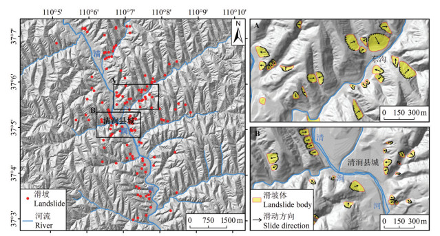
受地质环境条件的影响,清涧县城区滑坡等地质灾害多发。城区范围内滑坡灾害主要发育在清涧河河谷两侧边坡上和黄土梁峁区的陡坡地段,稳定性差或较差,均为黄土滑坡,且以小型浅层滑坡为主。滑坡形态特征较明显,易识别,后壁平面形态多呈典型的圈椅状,坡度在20°~65°。降雨、人工削坡取土等是滑坡的主要诱发因素。通过清涧县城区地质灾害调查,清涧县城区周边斜坡地带共发育黄土滑坡138处(图 1),以浅层滑坡为主,广泛分布于黄土梁峁侧壁的沟壑地带。
3. 城区斜坡单元划分与地形参数提取
3.1 斜坡单元划分与滑坡密度计算
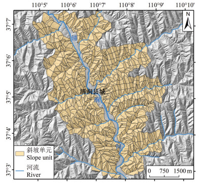
斜坡是滑坡发生的基本地形地貌单元,因此斜坡单元是进行滑坡危险性评价的理想单元,也是跟现场实际情况较为符合的(薛强等,2015)。本研究的基础数据来源于清涧县城区地质灾害野外调查,调查范围为清涧县城及周边区域的斜坡地带,面积31.4 km2。按照河流沟谷的发育情况和地形地貌的完整性,将清涧县城及周边区域的斜坡地带共划分为925个斜坡单元,其中单元面积最小为0.48×10⁴ m2,最大为14.59×10⁴ m2,平均为3.40×10⁴ m2(图 2)。
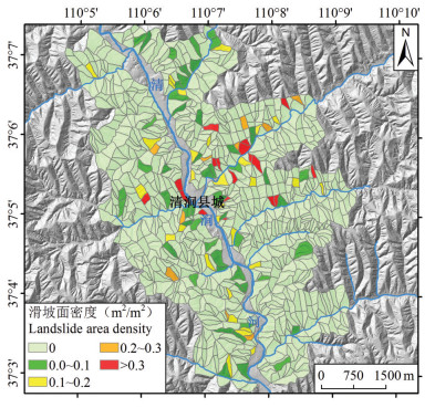
在滑坡野外调查及填图的基础上,采用滑坡体的面积指标,利用ArcGIS平台,计算清涧县城及周边区域斜坡单元内已发生滑坡的面密度,即滑坡体面积占所处斜坡单元面积的比例,单位:m2/m2(图 3)。
3.2 斜坡单元地形参数提取
清涧县城区及周边地形破碎,可形成滑坡的斜坡单元发育,所有斜坡单元均覆盖有较厚的黄土层,黄土滑坡即发生在黄土层内。黄土斜坡在不同坡度、坡高、坡型情况下,发生滑坡的概率也有所不同,因此需首先提取斜坡单元的基本形态参数。
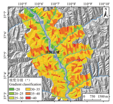
坡度提取:利用ArcGIS从清涧县城区及周边1:1万DEM数据中提取栅格坡度信息,然后在斜坡单元内求取栅格坡度平均值作为该斜坡体坡度指标(图 4)。
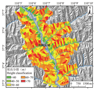
坡高提取:斜坡高度(坡高)可利用地形起伏度来间接获取,地形起伏度是指在一个特定的区域内,最高点高程与最低点高程的差值。从清涧县城区及周边1:1万DEM数据中按5×5单元格(25 m×25 m)间距计算地形起伏度,然后在斜坡单元内求取地形起伏度平均值作为该斜坡体坡高指标(图 5)。
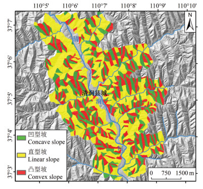
坡型提取:坡型是指地表坡面的形态,可分为直型坡、凸型坡和凹型坡3种基本类型,在GIS中坡型可以利用地表的曲率P进行描述和量化。当地表曲率P>0时,坡型为凸型坡;当地表曲率P=0时,坡型为直型坡;当地表曲率P < 0时,坡型为凹型坡。在实际地形中,地表曲率P=0的平直坡极少,为了更加直观地反映研究区坡型情况,经过计算和现场调查核实,当-0.5 < P < 0.5时,斜坡总体为直线型,且该取值范围内的坡型对地质灾害的贡献一致。因此做如下定义:当P≥0.5时,坡型为凸型坡;当-0.5 < P < 0.5时,坡型为直型坡;当P≤-0.5时,坡型为凹型坡。按照该取值范围定义的坡型与研究区实际情况一致(图 6)。
4. 城区斜坡危险性评价
本文所指危险性是指黄土斜坡在一定降雨入渗引发土体含水率增大的情况下,发生黄土滑坡的概率。由于黄土滑坡发生在黄土层内部,其影响因素主要有两类:一类为内在控制因素,主要包括坡度、坡高、坡型等基本形态参数,以及土体物理力学性质;另一类为外在诱发因素,主要为降雨引发土体含水率增大,进而导致抗剪强度降低,最终促使滑坡发生的力学行为。因此,在一定的坡度、坡高、坡型情况下,当土体含水率达到什么程度时斜坡会发生黄土滑坡显得尤为重要(薛强等,2018)。
4.1 斜坡稳定性分析
当斜坡坡度、坡高、坡型不同时,其发生黄土滑坡的概率也不同。因此,将研究区范围内的斜坡单元按照不同的坡度、坡高和坡型分别进行稳定性计算。本文采用Mohr-Coulomb准则作为本构模型,选用Morgenstern- Price作为分析模型,运用GeoStudio软件中的SLOP/W模块分别进行不同含水率工况下不同斜坡类型的斜坡稳定性计算,稳定性计算所选参数如表 1。本文将城区周边斜坡单元作为一个整体进行稳定性分析,当斜坡单元内包含滑坡体时,则稳定性分析剖面切过滑坡体。
表 1 清涧县城区不同含水率工况下的土体物理力学参数Table 1. Physical and mechanical parameters of soil under different water values in Qingjian City
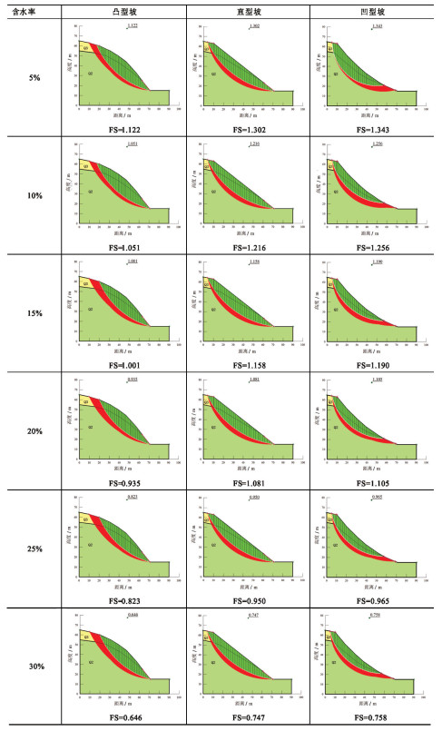
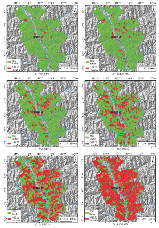
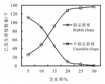
图 7为坡高50 m、坡度35°的黄土斜坡在不同坡型、不同含水率工况下的稳定性计算模型及结果,图中所列为最小稳定性系数。在清涧县城区,根据斜坡工程地质测绘,晚更新世黄土一般披覆在中更新世黄土之上,晚更新世黄土披覆厚度不等,一般5~15 m,平均约10 m。因此,在稳定性计算模型中,为简便起见,将晚更新世黄土厚度统一设定为10 m。在同一工况条件下,凸型坡最易发生滑坡,凹型坡最不易发生滑坡。其他工况条件类似。本次将最小稳定性系数>1.0的判定为稳定,最小稳定性系数≤1.0的判定为不稳定,图 8为清涧县城区斜坡单元在含水率分别为5%、10%、15%、20%、25%、30%不同工况下的稳定性计算结果。
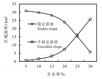
清涧县城区及周边区域斜坡在不同含水率工况下稳定性计算结果如表 2,由表 2可知,随着土体含水率的逐渐增加,城区内稳定斜坡的面积逐渐减少,不稳定斜坡的面积逐渐增大(图 9)。当斜坡土体含水率为5%时,稳定斜坡和不稳定斜坡面积占所有斜坡面积的比例分别为98.06%和1.94%;当斜坡土体含水率增加到30%时,稳定斜坡和不稳定斜坡面积占所有斜坡面积的比例分别变为18.21%和81.79%。
表 2 清涧县城区不同含水率工况下斜坡单元稳定性计算结果统计Table 2. Statistics of calculation results of slope under different water values in Qingjian City
同时,随着斜坡土体含水率的增加,不稳定斜坡单元内包含的已发生滑坡的数量亦逐渐增加,说明已发生滑坡的斜坡较原始的自然斜坡更容易失稳(图 10)。当斜坡土体含水率从5%增加到30%时,不稳定斜坡单元内已发生滑坡所占比例从18.84%增加到99.28%,说明有99.28%的已发生滑坡处于不稳定状态。
4.2 斜坡失稳危险性评价
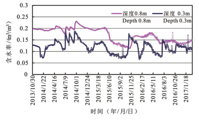
降雨在没有优势入渗通道的情况下,其在黄土中的入渗深度有限(薛强等,2014)。对陕北地区黄土斜坡浅层土体含水率进行了3个水文年的连续监测(图 11),监测时间:2013年10月30日至2017年3月7日。
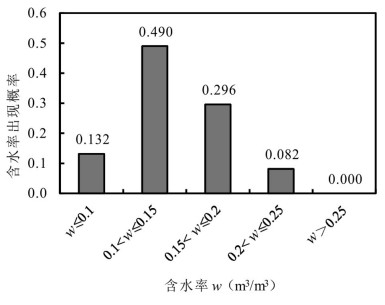
对监测结果进行统计分析,发现土体含水率w≤0.1的概率为0.132,土体含水率0.1<w≤0.15的概率为0.490,土体含水率0.15<w≤0.2的概率为0.296,土体含水率0.2<w≤0.25的概率为0.082,土体含水率w>0.25的概率为0(图 12)。根据黄土斜坡在不同含水率工况下的稳定性计算结果,按照土体含水率出现的概率进行斜坡失稳危险性评价,可将斜坡失稳危险性分为危险性很高、危险性高、危险性中等和危险性低4个级别(表 3)。
表 3 斜坡失稳危险性分级Table 3. Classification table of slope instability hazard
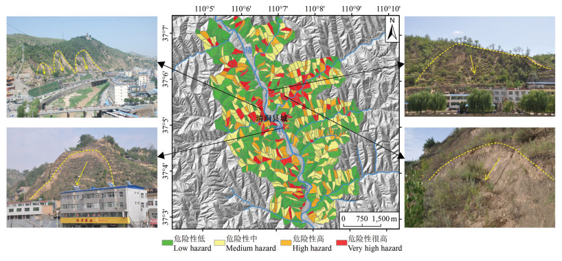
土体含水率w≤0.15出现的概率为0.622,即出现该含水率工况的概率很高,因此将此含水率下计算的不稳定(失稳概率很高)斜坡单元定为危险性很高区。土体含水率0.15<w≤0.2出现的概率为0.296,即认为出现该含水率工况的概率高,因此将此含水率下计算的不稳定斜坡单元(除去危险性很高区)为危险性高区。土体含水率0.2<w≤0.25出现的概率为0.082,即认为出现该含水率工况的概率为中等,因此将此含水率下计算的不稳定斜坡单元(除去危险性很高和危险性高区)为危险性中区。土体含水率w>0.25出现的概率为0,因此将危险性很高、危险性高和危险性中区之外的斜坡单元均定为危险性低区(图 13)。
危险性很高区:主要分布在清涧县城清涧河一带,以及东沟东门湾一带,其他地段也有零星分布。危险性很高区包含斜坡单元共112个,面积共3.27 km2,共包含已发生滑坡点92个。
危险性高区:主要分布在清涧县城附近西砭沟、赤土沟一带,与危险性很高区交叉分布,其他地段也有零星分布。危险性高区包含斜坡单元共128个,面积共4.19 km2,共包含已发生滑坡点36个。
危险性中区:在清涧河及其一级支流沿岸斜坡地带均有分布。危险性中区包含斜坡单元共251个,面积共8.75 km2,共包含已发生滑坡点6个。
危险性低区:在清涧河及其一级支流沿岸斜坡地带均有分布。危险性低区包含斜坡单元共434个,面积共15.20 km2,共包含已发生滑坡点4个。
5. 结论
(1)通过清涧县城区地质灾害调查,清涧县城区周边斜坡地带共发育滑坡138处,以浅层滑坡为主,广泛分布于黄土梁峁侧壁的沟壑地带。按照河流沟谷的发育情况和地形地貌的完整性,将清涧县城及周边区域的斜坡地带共划分为925个斜坡单元,单元面积平均为3.40×10⁴ m2。
(2)当斜坡坡度、坡高、坡型不同时,发生黄土滑坡的概率也不同。将研究区范围内的斜坡单元按照不同的坡度、坡高和坡型分别进行不同含水率工况下的斜坡稳定性计算,并结合土体含水率出现概率确定斜坡危险性。
(3)土体含水率w≤0.15出现的概率很高,在此含水率工况下计算所得的不稳定斜坡单元为危险性很高区,面积共3.27 km2,包含斜坡单元112个,包含已发生滑坡点92个;土体含水率0.15<w≤0.2出现的概率高,在此含水率工况下计算所得的不稳定斜坡单元(除去危险性很高区)为危险性高区,面积共4.19 km2,包含斜坡单元128个,包含已发生滑坡点36个;土体含水率0.2<w≤0.25出现的概率中,在此含水率工况下计算所得的不稳定斜坡单元(除去危险性很高和危险性高区)为危险性中区,面积共8.75 km2,包含斜坡单元251个,包含已发生滑坡点6个;土体含水率w>0.25出现的概率低,在此含水率工况下计算所得的不稳定和稳定斜坡单元(除去危险性很高、危险性高和危险性中区)为危险性低区,面积共15.20 km2,包含斜坡单元434个,包含已发生滑坡点4个。
致谢: 衷心感谢项目组成员王佳运、贾俊、徐继维、张亮在野外调查工作中付出的辛苦劳动。 -
表 1 清涧县城区不同含水率工况下的土体物理力学参数
Table 1 Physical and mechanical parameters of soil under different water values in Qingjian City

表 2 清涧县城区不同含水率工况下斜坡单元稳定性计算结果统计
Table 2 Statistics of calculation results of slope under different water values in Qingjian City

表 3 斜坡失稳危险性分级
Table 3 Classification table of slope instability hazard

-
Chang Jinyuan, Bao Han, Wu Faquan, Chang Zhonghua, Luo Hao. 2015. Discussion on stability of shallow landslide under rainfall[J]. Rock and Soil Mechanics, 36(4):995-1001(in Chinese with English abstract).
Grant A, Wartman J, Abou-Jaoude G. 2016. Multimodal method for coseismic landslide hazard assessment[J]. Engineering Geology, 212:146-160. doi: 10.1016/j.enggeo.2016.08.005
Gu Tianfeng, Wang Jiading, Fu xinping. 2013. Regional slope stability analysis method based on the slope unit[J]. Scientia Geographica Sinica, 33(11):1400-1405(in Chinese with English abstract).
Guzzetti F, Galli M, Reichenbach P, Ardizzone F, Cardinali M. 2006.Landslide hazard assessment in the Collazzone area, Umbria, Central Italy[J]. Natural Hazards and Earth System Sciences, 6:115-131. doi: 10.5194/nhess-6-115-2006
Hu Ruilin, Fan Linfeng, Wang Shanshan, Wang Lichao, Wang Xueliang. 2013. Theory and method for landslide risk assessmentcurrent status and future development[J]. Journal of Engineering Geology, 21(1):76-84(in Chinese with English abstract).
Huang Runqiu. 2007. Large-scale landslides and their sliding mechanisms in China since the 20th century[J]. Chinese Journal of Rock Mechanics and Engineering, 26(3):433-454(in Chinese with English abstract).
Jia N, Mitani Y, Xie M, Djamaluddin I. 2012. Shallow landslide hazard assessment using a three-dimensional deterministic model in a mountainous area[J]. Computers and Geotechnics, 45:1-10. doi: 10.1016/j.compgeo.2012.04.007
Martha T R, Westen C J, Kerle N, Jetten V, Kumar K V. 2013.Landslide hazard and risk assessment using semi-automatically created landslide inventories[J]. Geomorphology, 184:139-150. doi: 10.1016/j.geomorph.2012.12.001
Park H J, Lee J H, Woo I. 2013. Assessment of rainfall-induced shallow landslide susceptibility using a GIS-based probabilistic approach[J]. Engineering Geology, 161:1-15. doi: 10.1016/j.enggeo.2013.04.011
Peng Ling, Niu Ruiqing, Zhao Yannan, Deng Qinglu. 2013. Risk assessment of a regional landslide:A case of Zigui County territory in Three Gorges Reservoir[J]. Journal of Jilin University(Earth Science Edition), 43(3):891-901(in Chinese with English abstract). http://en.cnki.com.cn/Article_en/CJFDTOTAL-CCDZ201303027.htm
Pradhan B, Lee S. 2010. Delineation of landslide hazard areas on Penang Island, Malaysia, by using frequency ratio, logistic regression, and artificial neural network models[J]. Environmental Earth Sciences, 60:1037-1054. doi: 10.1007/s12665-009-0245-8
Shi Jusong, Shi Ling, Wu Shuren, Wang Tao. 2009. Difficulties and countermeasures in the practice of landslide risk assessment[J]. Geological Bulletin of China, 28(8):1020-1030(in Chinese with English abstract).
Wang Yunlong, Wen Baoping. 2011. Risk study of landslide geohazards in Lanzhou City[J]. Geology in China, 38(6):1593-1598(in Chinese with English abstract).
Xue Qiang, Tang Yaming, Sun Pingping, Bi Junbo. 2014. Temporalspatial distribution of soil water content in loess slope subjected to rainfall infiltration[J]. Bulletin of Soil and Water Conservation, 34(2):53-56(in Chinese with English abstract).
Xue Qiang, Zhang Maosheng, Bi Junbo, Wang Xiaofei, Lin Longchao. 2019. Exfoliation erosion and deformation failure of excavated loess slope[J]. Northwestern Geology, 52(2):158-166(in Chinese with English abstract). http://www.cnki.com.cn/Article/CJFDTotal-XBDI201902020.htm
Xue Qiang, Zhang Maosheng, Gao Bo, Zhang Jianlong. 2018. Risk assessment of geological hazards in Suide City, Shaanxi Province[J]. Journal of Engineering Geology, 26(3):711-719(in Chinese with English abstract).
Xue Qiang, Zhang Maosheng, Li Lin. 2015. Loess landslide susceptibility evaluation based on slope unit and information value method in Baota District[J]. Geological Bulletin of China, 34(11):2108-2115(in Chinese with English abstract). http://www.researchgate.net/publication/292463659_Loess_landslide_susceptibility_evaluation_based_on_slope_unit_and_information_value_method_in_Baota_District_Yan'an
Xue Qiang, Zhang Maosheng. 2018. Monitoring, early warning and deformation characteristics of Yantu' an landslide in Yan' an[J]. Northwestern Geology, 51(2):220-226(in Chinese with English abstract).
Yan Ge, Liang Shouyun, Zhao Hongliang. 2017. An approach to improving slope unit division using GIS technique[J]. Scientia Geographica Sinica, 37(11):1764-1770(in Chinese with English abstract).
Yin Yueping, WangWenpei, Zhang Nan, Yan Jingkai, Wei Yunjie, Yang Longwei. 2017. Long runout geological disaster initiated by the ridge-top rockslide in a strong earthquake area:A case study of the Xinmo landslide in Maoxian County, Sichuan Province[J]. Geology in China, 44(5):827-841(in Chinese with English abstract). http://en.cnki.com.cn/Article_en/CJFDTotal-DIZI201705002.htm
Zhang Maosheng, Li Tonglu. 2011. Triggering factors and forming mechanism of loess landslides[J]. Journal of Engineering Geology, 19(4):530-540(in Chinese with English abstract).
Zhang Maosheng, Xiao Peixi, Wei Xingli. 2006. A preliminary discussion of the occurrence of landslide in the Baota district of Yan'an City[J]. Hydrogeology & Engineering Geology, 33(6):72-74(in Chinese with English abstract). http://en.cnki.com.cn/Article_en/CJFDTOTAL-SWDG200606017.htm
Zhang Maosheng, Xue Qiang, Jia Jun, Xu Jiwei, Gao Bo, Wang Jiayun. 2019. Methods and practices for the investigation and risk assessment of geo-hazards in mountains towns[J]. Northwestern Geology, 52(2):125-135(in Chinese with English abstract).
Zhang Shuxuan, Yang Weimin, Cheng Xiaojie, Tian You, Li Hao, Huang Xiao. 2017. Genetic mechanism and stability analysis of loess landslides group in Tianshui Hongqishan, Gansu Province[J]. Geology in China, 44(5):924-937(in Chinese with English abstract). http://en.cnki.com.cn/Article_en/CJFDTotal-DIZI201705008.htm
Zhao Liangjun, Chen Donghua, Li Hu, Liu Yufeng. 2017. A method to assess landslide susceptibility by using logistic regression model for Guozigou Region, Xinjinag[J]. Mountain Research, 35(2):203-211(in Chinese with English abstract). http://en.cnki.com.cn/Article_en/CJFDTotal-SDYA201702010.htm
Zhuang Jianqi, Peng Jianbing, Zhang Liyong. 2013. Risk assessment and prediction of the shallow landslide at different precipitation in Loess Plateau[J]. Journal of Jilin University(Earth Science Edition), 43(3):867-876(in Chinese with English abstract).
常金源, 包含, 伍法权, 常中华, 罗浩. 2015.降雨条件下浅层滑坡稳定性探讨[J].岩土力学, 36(4):995-1001. 谷天峰, 王家鼎, 付新平. 2013.基于斜坡单元的区域斜坡稳定性评价方法[J].地理科学, 33(11):1400-1405. 胡瑞林, 范林峰, 王珊珊, 王立朝, 王学良. 2013.滑坡风险评价的理论与方法研究[J].工程地质学报, 21(1):76-84. 黄润秋. 2007.20世纪以来中国的大型滑坡及其发生机制[J].岩石力学与工程学报, 26(3):433-454. 彭令, 牛瑞卿, 赵艳南, 邓清禄. 2013.区域滑坡灾害风险评估——以长江三峡库区秭归县为例[J].吉林大学学报(地球科学版), 43(3):891-901. 石菊松, 石玲, 吴树仁, 王涛. 2009.滑坡风险评估实践中的难点与对策[J].地质通报, 28(8):1020-1030. 王云龙, 文宝萍. 2011.兰州市滑坡地质灾害危险性研究[J].中国地质, 38(6):1593-1598. http://geochina.cgs.gov.cn/geochina/ch/reader/view_abstract.aspx?file_no=20110619&flag=1 薛强, 唐亚明, 孙萍萍, 毕俊擘. 2014.降雨入渗对黄土斜坡土体含水率时空分布特性的影响[J].水土保持通报, 34(2):53-56. 薛强, 张茂省, 毕俊擘, 王晓飞, 林隆超. 2019.开挖型黄土边坡剥落侵蚀作用及变形破坏研究[J].西北地质, 52(2):158-166. 薛强, 张茂省, 高波, 张建龙. 2018.陕西省绥德县城区地质灾害风险评估[J].工程地质学报, 26(3):711-719. 薛强, 张茂省, 李林. 2015.基于斜坡单元与信息量法结合的宝塔区黄土滑坡易发性评价[J].地质通报, 34(11):2108-2115. 薛强, 张茂省. 2018.延安淹土安滑坡监测预警及变形特征[J].西北地质, 51(2):220-226. 颜阁, 梁收运, 赵红亮. 2017.基于GIS的斜坡单元划分方法改进与实现[J].地理科学, 37(11):1764-1770. 殷跃平, 王文沛, 张楠, 闫金凯, 魏云杰, 杨龙伟. 2017.强震区高位滑坡远程灾害特征研究——以四川茂县新磨滑坡为例[J].中国地质, 44(5):827-841. http://geochina.cgs.gov.cn/geochina/ch/reader/view_abstract.aspx?file_no=20170501&flag=1 张茂省, 李同录. 2011.黄土滑坡诱发因素及其形成机理研究[J].工程地质学报, 19(4):530-540. 张茂省, 校培喜, 魏兴丽. 2006.延安市宝塔区崩滑地质灾害发育特征与分布规律初探[J].水文地质工程地质, 33(6):72-74. 张茂省, 薛强, 贾俊, 徐继维, 高波, 王佳运. 2019.山区城镇地质灾害调查与风险评价方法及实践[J].西北地质, 52(2):125-135. 张树轩, 杨为民, 程小杰, 田尤, 李浩, 黄晓. 2017.甘肃天水红旗山黄土滑坡群成因及稳定性分析[J].中国地质, 44(5):924-937. http://geochina.cgs.gov.cn/geochina/ch/reader/view_abstract.aspx?file_no=20170507&flag=1 赵良军, 陈冬花, 李虎, 刘玉锋. 2017.基于二元逻辑回归模型的新疆果子沟滑坡风险区划[J].山地学报, 35(2):203-211. 庄建琦, 彭建兵, 张利勇. 2013.不同降雨条件下黄土高原浅层滑坡危险性预测评价[J].吉林大学学报(地球科学版), 43(3):867-876. -
期刊类型引用(12)
1. 毛正君,于海泳,梁伟,马旭,仲佳鑫,高广胜,石硕杰,田彦山. 基于无人机倾斜摄影测量三维建模的区域黄土滑坡识别及特征分析. 中国地质. 2024(02): 561-576 .  本站查看
本站查看
2. 李星,杨赛,李远耀,殷坤龙,王伟. 面向区域滑坡易发性精细化评价的改进斜坡单元法. 地质科技通报. 2023(03): 81-92 .  百度学术
百度学术
3. 刘军,王磊. 基于无人机倾斜摄影的黄土滑坡调查与危险性评价. 水土保持通报. 2023(02): 139-147 .  百度学术
百度学术
4. 薛强,张茂省,董英,孟晓捷,郭小鹏,冯卫,洪勃,王涛,刘文辉,田中英,张戈,卢娜. 基于DEM和遥感的黄土地质灾害精细化风险识别——以陕北黄土高原区米脂县为例. 中国地质. 2023(03): 926-942 .  本站查看
本站查看
5. 何书,鲜木斯艳·阿布迪克依木,胡萌,陈康. 基于自组织特征映射网络-随机森林模型的滑坡易发性评价——以江西大余县为例. 中国地质灾害与防治学报. 2022(01): 132-140 .  百度学术
百度学术
6. 王虎,郭怀军,王益民,薛强,王凯,查显锋,王晓勇,孙萍萍,程秀娟. 陕西安塞城区基岩崩塌主控构造因素分析. 中国地质灾害与防治学报. 2022(03): 51-60 .  百度学术
百度学术
7. 邹凤钗,冷洋洋,陶小郎,何松标. 基于斜坡单元的滑坡风险识别——以贵州万山浅层土质斜坡为例. 中国地质灾害与防治学报. 2022(03): 114-122 .  百度学术
百度学术
8. 祁于娜,王磊. 层次分析-熵值定权法应用于山区城镇地质灾害易发性评价. 测绘通报. 2021(06): 112-116 .  百度学术
百度学术
9. 赵利云,张茂省,孙萍萍,程秀娟,刘超男. 基于原位监测的浅层黄土斜坡水分运移规律分析. 地质与资源. 2021(04): 492-498 .  百度学术
百度学术
10. 谢家龙,李远耀,王宁涛,刘月. 考虑库水位及降雨联合作用的云阳县区域滑坡危险性评价. 长江科学院院报. 2021(12): 72-81+90 .  百度学术
百度学术
11. 胡鹏,杨东强,王荐霖. 四川省雅江县上游河段滑坡灾害危险性评价. 地质与资源. 2021(06): 722-732 .  百度学术
百度学术
12. 徐晨栋,苑康泽,郭子坤,任钊. 清子高速某工程滑坡诱发机制及治理模拟. 地质与资源. 2020(02): 196-201 .  百度学术
百度学术
其他类型引用(9)


 下载:
下载:
