-
摘要:
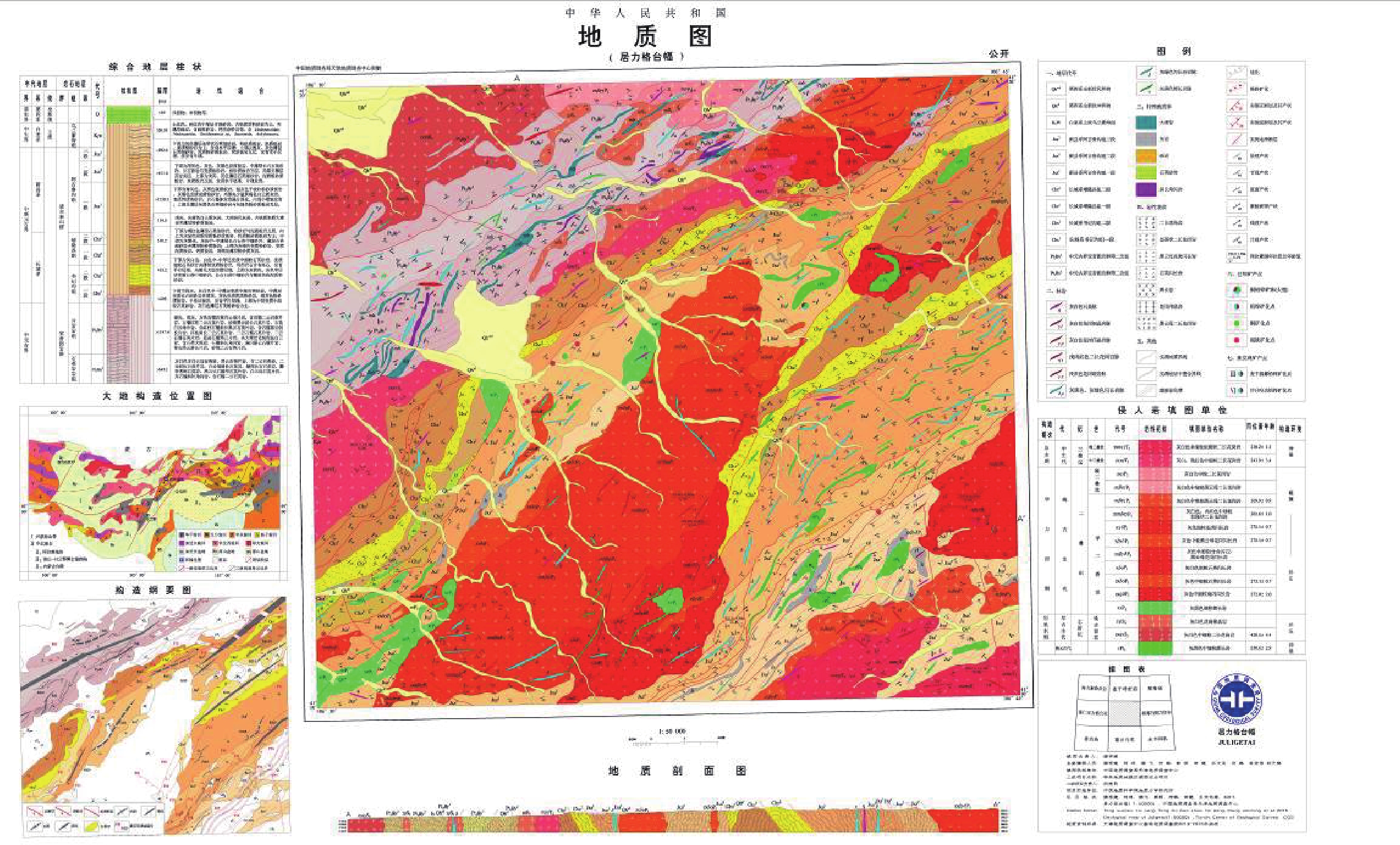
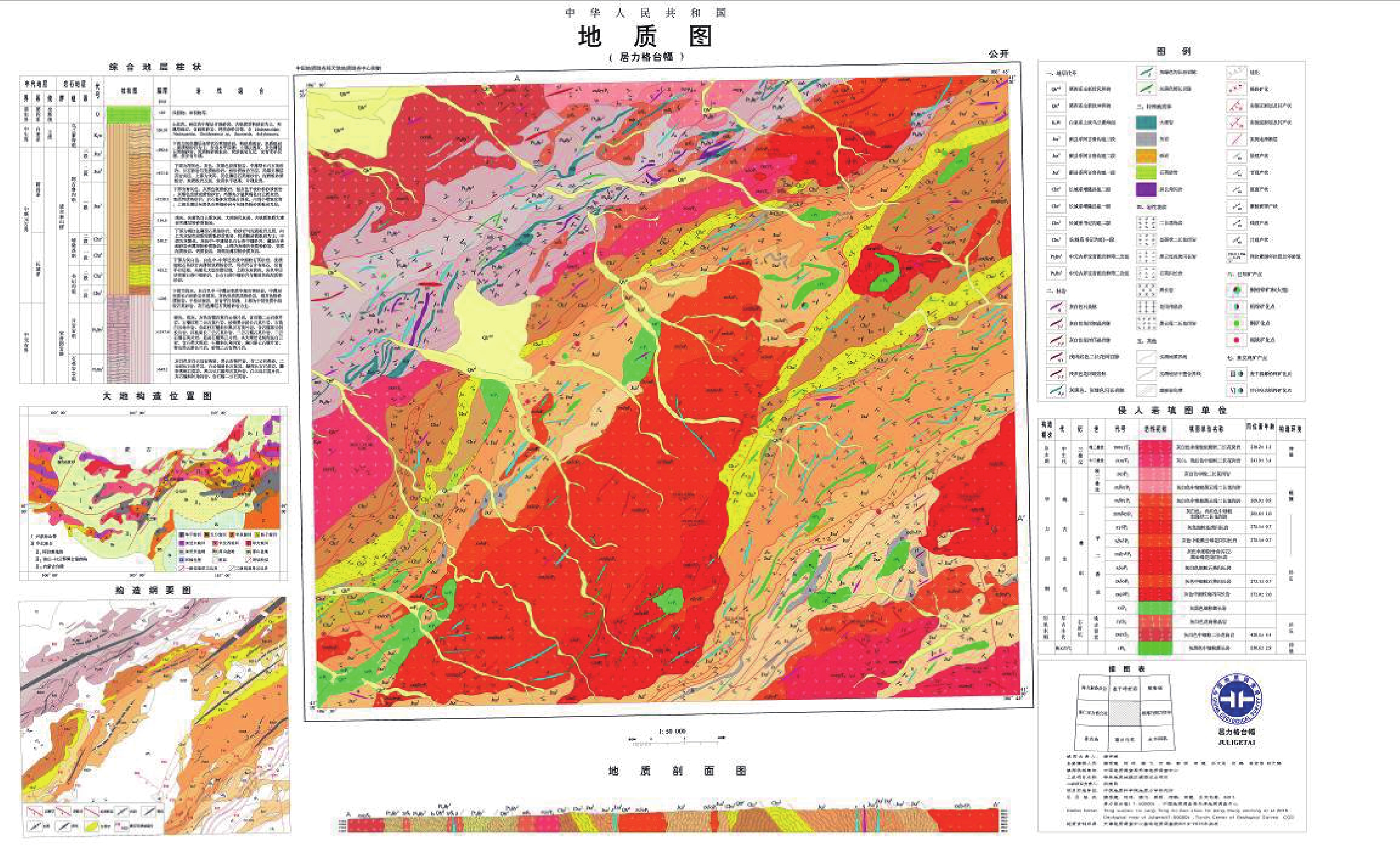
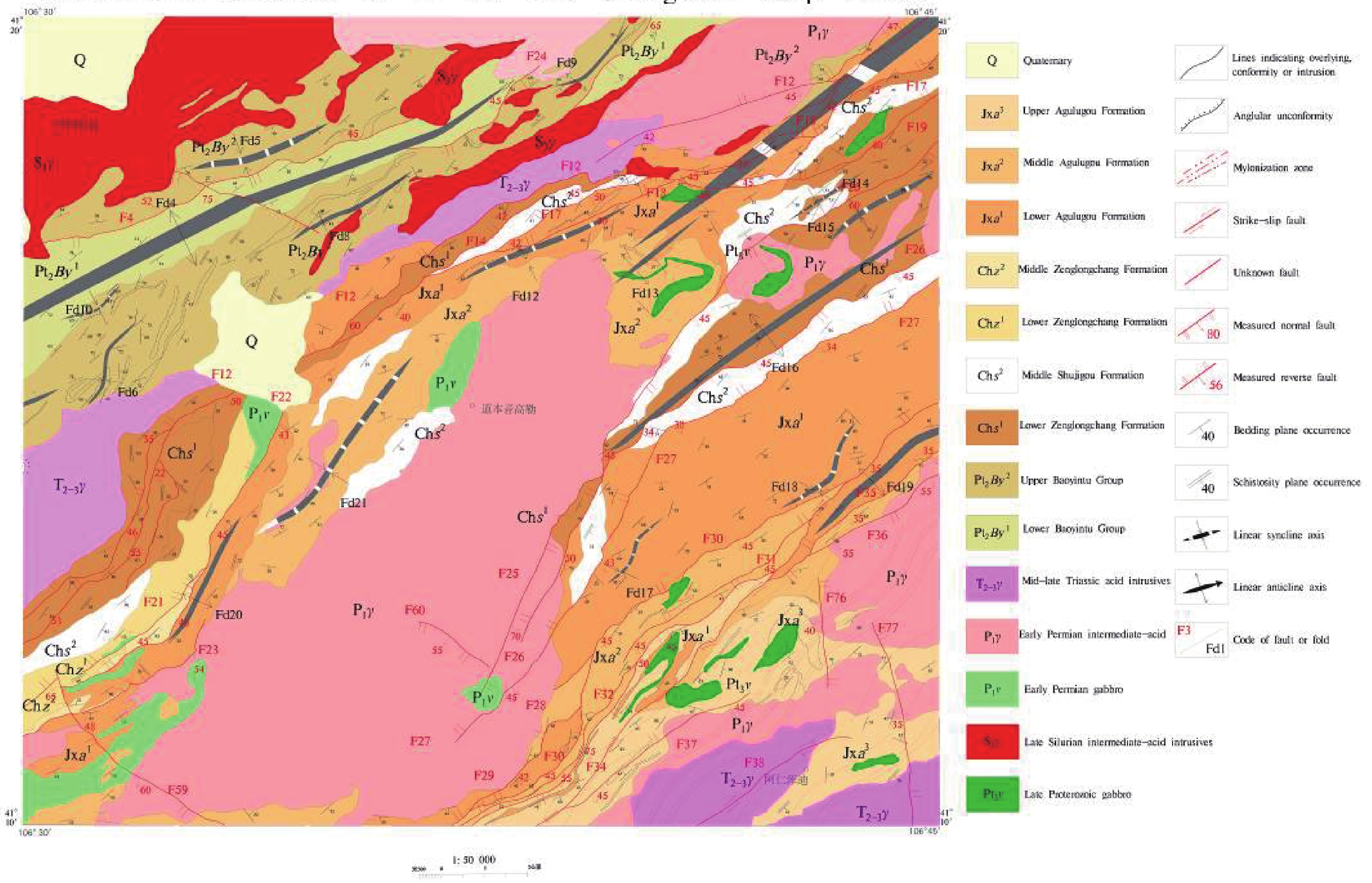
内蒙古居力格台幅 (K48E017019)1∶50 000地质图是根据《区域地质调查技术要求(1∶50 000)》(DD 2006-XX)和行业统一标准及要求,充分利用1∶200 000区域地质、1∶50 000矿产调查资料,结合Spot、ETM、Aster等多种遥感影像,以造山带理论指导填图的重要成果图件之一。本次运用复杂构造区的地质填图方法,创新性地在地质图上表达了多期构造形迹及其产状要素;图件全面反映了狼山地区乌拉特后旗一带不同侵入体的空间展布和侵入岩的岩浆序列,以及渣尔泰山群变质沉积岩的韵律和变形特征、沉积时代和沉积环境;进一步明确了霍各乞大型铜矿的赋矿围岩为阿古鲁沟组二段炭质–钙质板岩,矿床总体位于该地层中片理褶皱形成的转折端部位。图幅数据库的数据内容包含有3个非正式填图单位,12个正式填图单位、3期岩浆事件和3期构造变形,以及120个岩石化学分析数据,13个样品的锆石U-Pb年龄数据,数据量为106 MB。数据库成果为1∶50 000造山带地质调查示范性成果,对造山带填图的图面表达具有引领作用,可为后续地质基础研究及找矿提供重要的基础资料支撑。
Abstract:The 1∶50 000 Geological Map of the Juligetai Map-sheet (K48E017019), Inner Mongolia was compiled according to the ‘Technical Requirements for Regional Geological Surveys (1∶50 000)’ (DD 2006-XX) and other uniform standards and requirements. It also makes full use of the data from the 1∶200 000 regional geological survey and 1∶50 000 mineral resource survey, and adopts various remote sensing imagery systems including Spot, ETM and Aster. It is an important mapping achievement guided by the orogenic belt theory. In the current project, a geological mapping method for complex tectonic areas was used to creatively express the structural features in multiple stages and their attitude features in geological maps. The map comprehensively reflects the spatial distribution of different intrusive bodies and magmatic sequence of intrusive rocks in the Wulatehou Banner in Langshan area, as well as the rhythm and deformation characteristics, sedimentary age and sedimentary environment of metamorphic sedimentary rocks of the Zhaertaishan Group. The wall-rocks of the Huogeqi Copper Deposit was further identified as carbonaceous-calcareous slates of the Agulugou Formation’s second member. The deposit is mostly located at the hinge zone of the schistose fold in the stratum. The map database includes 3 informal mapping units, 12 official mapping units, 3 periods of magmatic events and 3 tectonic deformations, in addition to 120 pieces of petrochemical analysis data and zircon U–Pb age data of 13 samples, with a data size of 106 MB. The database represents an exemplary result of the 1∶50 000 orogenic belt geological survey. It plays a leading role in orogenic belt mapping and is able to support subsequent basic geological research and prospecting by providing essential basic data.
-
Keywords:
- Inner Mongolia /
- Langshan area /
- Juligetai Map-sheet /
- 1∶50 000 /
- geological map /
- database /
- Huogeqi Copper Deposit /
- Paleozoic magmatism
-
1. 引言
花岗岩是组成地球大陆地壳的重要岩石类型,是地球大陆地壳与地球大洋地壳乃至太阳系中其他类地行星的地壳相区别的最重要的标志(Pitcher, 1997)。花岗岩在大陆地壳增生和再循环的过程中起到了不可或缺的重要作用,在岩石圈构造演化、地球动力学和成矿作用研究中具有重要的意义(Barbarin,1999;李金东,2005;柏道远,2008;华仁民等, 2012, 2013;陈骏等,2014)。
华南加里东期花岗岩主要分布在湖南、江西、广西、广东和福建等省份,总面积超过2.2万km2(程顺波等,2013)。黄汲清早在1937年就提出华南可能存在加里东期花岗岩(黄汲清,1994)。徐克勤在1957年首先发现并证实华南存在加里东期花岗岩体(徐克勤等,1960)。此后,华南加里东期花岗岩逐渐引起地质界重视,吸引众多地质工作者加入到研究行列中(徐克勤等,1963;王德滋等,1978)。从20世纪80年代开始,随着地球化学、同位素地球化学分析方法和岩石定年方法的不断更新进步,对华南加里东期花岗岩的研究告别了单纯的经验判断;特别是到了90年代,随着高精度SHRIMP和LAICP-MS单颗粒锆石定年和锆石Lu-Hf同位素示踪技术的诞生,对华南加里东期花岗岩的研究有了强有力的科学技术支撑,研究水平不断提高。但是与华南燕山期花岗岩研究程度相比,华南加里东期花岗岩的研究明显不足,对其与成矿的关系认识不清,对其形成的构造背景的认识也存在很大的争议,目前主要有洋壳俯冲造山和板内挤压造山两种观点(孙明志等,1990;周新民等,2003;许德如等,2006;孙涛等,2006)。
苗儿山岩体位于湘西南和桂北交界处,为一个以加里东期花岗岩为主体,包括晋宁期、印支期和燕山期花岗岩的复式岩体,由于其构造岩浆活动强烈、形成时间跨度长,因此对于研究华南地区的花岗岩成因、成矿作用和大地构造演化具有重要的意义。另外,近几年针对苗儿山岩体的找矿工作连续取得较大突破,发现了多个大、中、小型钨(锡、钼、铜)矿床(刘伟等,2011;伍静等,2012;杜云等,2017),引起了越来越多学者的关注和研究。本文利用LA-ICP-MS单颗粒锆石U-Pb定年、X射线荧光光谱分析、高分辨等离子体质谱分析、Sr-Nd同位素分析和O同位素分析等高精度的分析测试手段,结合前人研究成果,对苗儿山岩体加里东期花岗岩的地球化学、锆石U-Pb年代学、Sr-Nd同位素和O同位素特征进行了系统研究,在此基础上,讨论加里东期花岗岩的形成构造背景和成因,可为华南地区花岗岩成岩理论研究的完善提供依据。
2. 岩体地质概况
苗儿山复式岩体位于湘西南与桂北交界处,总出露面积约1600 km2,其北段处于湖南省境内,呈南北向展布,出露面积约450 km2,南段主要位于广西区境内,呈北东向展布。苗儿山复式岩体由加里东期花岗岩构成主体,晋宁期、印支期和燕山期花岗岩呈小岩株状广泛分布其中,构成补体(图 1)。
![]() 图 1 大地构造位置(a)和区域地质略图(b)1—白垩系;2—泥盆系至三叠系;3—寒武系至奥陶系;4—新元古界青白口系至震旦系;5—燕山期花岗岩;6—印支期花岗岩;7—加里东期花岗岩;8—新元古代晋宁期花岗闪长岩;9—地质界线;10—断层;11—U-Pb年龄样采样位置及编号;12—研究区范围Figure 1. Tectonic location(a) and regional geological map(b)1-Cretaceous system; 2-Devonian system to Triassic system; 3-Cambrian system to Ordovician system; 4-Neoproterozoic Qingbaikou system to Sinian system; 5-Yanshanian granite; 6-Indosinian granite; 7-Caledonian granite; 8-Neoproterozoic Jinningian granodiorite; 9-Geological boundary; 10-Fault; 11-U-Pb age sampling location and numbering; 12-The study area
图 1 大地构造位置(a)和区域地质略图(b)1—白垩系;2—泥盆系至三叠系;3—寒武系至奥陶系;4—新元古界青白口系至震旦系;5—燕山期花岗岩;6—印支期花岗岩;7—加里东期花岗岩;8—新元古代晋宁期花岗闪长岩;9—地质界线;10—断层;11—U-Pb年龄样采样位置及编号;12—研究区范围Figure 1. Tectonic location(a) and regional geological map(b)1-Cretaceous system; 2-Devonian system to Triassic system; 3-Cambrian system to Ordovician system; 4-Neoproterozoic Qingbaikou system to Sinian system; 5-Yanshanian granite; 6-Indosinian granite; 7-Caledonian granite; 8-Neoproterozoic Jinningian granodiorite; 9-Geological boundary; 10-Fault; 11-U-Pb age sampling location and numbering; 12-The study area苗儿山复式岩体出露于苗儿山复式背斜核部,其中加里东期花岗岩构成的主体与前泥盆纪地层呈侵入接触关系,而与泥盆系、白垩系则呈沉积接触关系。前泥盆纪地层主要包括青白口系、南华系、震旦系和奥陶系(缺失志留系),为一套浅海—半深海相类复理石砂泥质碎屑沉积夹硅质、炭泥质沉积,部分层位夹碳酸盐岩;泥盆系为滨浅海碎屑岩—浅海台地、台盆相碳酸盐岩沉积;白垩系为陆相红盆碎屑沉积。苗儿山岩体及其四周围岩中断裂十分发育,其中NNE—NE向断裂规模最大,数量最多,构造形迹非常醒目,所谓的“城步—江口大断裂”,即为该组出露总宽度达数十千米的断裂的统称,它控制了苗儿山岩体的空间展布,并在多次继承性活动中对苗儿山岩体造成了明显的切割破坏作用。
3. 岩石学特征
按地球化学、同位素年代学及野外地质特征,加里东期花岗岩从早到晚可分为六个侵入次,分别为第一侵入次中细粒斑状黑云母二长花岗岩(ηγSa)、第二侵入次中粗粒斑状黑云母二长花岗岩(ηγSb)、第三侵入次中粒斑状黑云母二长花岗岩(ηγSc)、第四侵入次中细粒黑云母二长花岗岩(ηγSd)、第五侵入次细粒斑状黑云母二长花岗岩(ηγSe)、第六侵入次细粒黑云母二长花岗岩(ηγSf)。各个侵入次之间均为侵入接触关系,具有较为明显的分界线(图 2a、b)。
![]() 图 2 加里东期不同侵入次花岗岩之间的典型接触特征a—第五侵入次花岗岩侵入于第四侵入次花岗岩中;b—第六侵入次花岗岩侵入于第五侵入次花岗岩中Figure 2. Representative contacts between the different episodes of Caledonian granitesa-A representative photo of the fifth episodic granites intruding into the fourth episodic granites; b-A representative photo of the sixth episodic granites intruding into the fifth episodic granites
图 2 加里东期不同侵入次花岗岩之间的典型接触特征a—第五侵入次花岗岩侵入于第四侵入次花岗岩中;b—第六侵入次花岗岩侵入于第五侵入次花岗岩中Figure 2. Representative contacts between the different episodes of Caledonian granitesa-A representative photo of the fifth episodic granites intruding into the fourth episodic granites; b-A representative photo of the sixth episodic granites intruding into the fifth episodic granites第一侵入次中细粒斑状黑云母二长花岗岩(ηγSa),主要由粒径10~30 mm的自形—半自形板状钾长石为斑晶(含量10%~30%)和粒径0.7~4.4 mm的他形石英、钾长石、半自形板状斜长石、片状黑云母、菱柱状角闪石等为基质(含量70%~90%)组成,构成似斑状结构,基质为中—细粒花岗结构(图 3a、b)。钾长石含量31%~45%,他形为主,具条纹结构、格子双晶,表面见石英、斜长石、黑云母等嵌晶。斜长石含量18%~29%,半自形板柱状,强绢云母化,发育聚片双晶,部分显环带构造。石英含量28%~33%,他形粒状、粒状集合体状,与长石互嵌或填隙长石粒间,微区可见石英呈文象状嵌布在钾长石中。黑云母含量4%~11%,片状、片状集合体状,褐色,含磷灰石、锆石、绿帘石等包体。角闪石含量微至1%,菱柱状,绿色,分散分布或包嵌于钾长石中。副矿物主要有金红石、磷灰石、锆石、绿帘石和黄铁矿,含少量方铅矿和磁铁矿。第一侵入次中可见少量暗色微粒包体,包体多呈不规则状或椭圆状,与围岩界线截然,直径一般在2~10 cm(图 3c)。包体具似斑状结构,块状构造。斑晶含量约4%,主要为斜长石斑晶,直径1.5~3 mm。基质含量约96%,具半自形粒状结构,颗粒间紧密镶嵌,主要由主要由斜长石(44%)、黑云母(30%)和石英(19%) 组成,含少量磷灰石(2%),及微量锆石(图 3d)。黑云母,棕褐色,自形—半自形板片状,部分可见针状金红石沿解理缝析出;石英,他形粒状,粒径约0.2~0.96 mm;磷灰石,无色,细小针柱状;锆石,无色粒状,粒径约0.2 mm。暗色微粒包体的岩性与寄主岩的岩性特征有显著差异,主要表现在颜色明显较深,矿物粒度明显较细,不含钾长石,斜长石和黑云母含量显著增加,石英含量明显减少。由于暗色微粒包体由两期先后结晶的矿物构成,具有明显的火成结构,且其组成矿物主要为斜长石、黑云母和石英,与火成岩、沉积岩部分熔融残余物(Tindle and Pearce, 1982)和壳幔混合成因的镁铁质微粒包体(MME)几乎不含石英的特征明显不同(Barbarin,2005),因此应该既不是地壳部分熔融过程中形成的耐熔残余物,也不是壳幔混合的产物,而是地壳中偏基性的岩石的熔融物,反映了地壳源区成分的不均一性。
![]() 图 3 加里东期第一、三侵入次花岗岩及包体的照片和显微照片a—第一侵入次花岗岩露头;b—第一侵入次花岗岩显微照片;c—细粒暗色包体手标本;d—细粒暗色包体显微照片;e—第三侵入次花岗岩露头;f—第三侵入次花岗岩显微照片Figure 3. Representative photographs and photomicrographs of the first and third episodic granites and enclaves from the Miao'ershan plutona-A representative outcrop of the first episodic granites; b-A representative photomicrograph of the first episodic granites; c-A representative hand specimen of the fine-grained dark enclaves; d-A representative photomicrograph of the fine dark enclaves; e-A representative outcrop of the third episodic granites; f-A representative photomicrograph of the third episodic granites
图 3 加里东期第一、三侵入次花岗岩及包体的照片和显微照片a—第一侵入次花岗岩露头;b—第一侵入次花岗岩显微照片;c—细粒暗色包体手标本;d—细粒暗色包体显微照片;e—第三侵入次花岗岩露头;f—第三侵入次花岗岩显微照片Figure 3. Representative photographs and photomicrographs of the first and third episodic granites and enclaves from the Miao'ershan plutona-A representative outcrop of the first episodic granites; b-A representative photomicrograph of the first episodic granites; c-A representative hand specimen of the fine-grained dark enclaves; d-A representative photomicrograph of the fine dark enclaves; e-A representative outcrop of the third episodic granites; f-A representative photomicrograph of the third episodic granites第二侵入次中粗粒斑状黑云母二长花岗岩(ηγSb),主要由粒径8~40 mm的自形—他形钾长石、斜长石、石英为斑晶(含量10%~20%)和粒径2~7mm的他形钾长石、石英、半自形板状斜长石、片状黑云母等为基质(含量80%~90%)组成,构成似斑状结构,基质为中—粗粒花岗结构。钾长石含量34%~48%,他形为主,具条纹结构、格子双晶,表面见石英、斜长石、黑云母等嵌晶。斜长石含量18%~38%,半自形板柱状,绢云母化、黏土化,发育聚片双晶,部分显环带构造。石英含量22%~35%,他形粒状、粒状集合体状,与长石互嵌或填隙长石粒间。黑云母含量约3%~6%,片状、细片集合体状,绿泥石化,解理缝析出钛铁质,生成绿帘石,含磷灰石包体。副矿物主要有金红石、磷灰石、锆石、绿帘石、黄铁矿和方铅矿,含少量黄铜矿和磁铁矿。
第三侵入次中粒斑状黑云母二长花岗岩(ηγSc),主要由粒径8~35 mm的自形—半自形板状钾长石为斑晶(含量10%~20%)和粒径2~5 mm的他形钾长石、石英、半自形板状斜长石、片状黑云母、细柱状帘石等为基质组成,构成似斑状结构,基质为中粒花岗结构(图 3e、f)。钾长石含量28%~50%,他形为主,具条纹结构、格子双晶,表面碎裂,裂隙中充填帘石、微晶石英等。斜长石含量18%~29%,半自形板柱状,强绢云母化,发育聚片双晶,部分显环带构造。石英含量28%~33%,他形粒状、粒状集合体状,与长石互嵌,部分细粒化重结晶的石英分布于石英或长石微裂隙中。黑云母含量4%~11%,片状、片状集合体状,绿泥石化,解理缝析出钛铁质,生成绿帘石,含磷灰石包体。绿帘石含量微至2%,柱状、柱粒状,主要与黑云母共生或分布在岩石微裂隙中。副矿物主要有金红石、磷灰石、锆石、绿帘石和黄铁矿,含少量方铅矿和磁铁矿。
第四侵入次中细粒黑云母二长花岗岩(ηγSd),主要由粒径0.5~3.6 mm的他形—半自形钾长石、半自形板状斜长石、它形粒状石英、片状黑云母等互相镶嵌组成,构成中细粒花岗结构。钾长石含量25%~43%,他形为主,隐显条纹结构、格子双晶,碎裂,具微裂隙,裂隙中充填氧化铁质物,表面嵌圆粒化石英、斜长石、黑云母等。斜长石含量20%~45%,半自形-自形板条状,绢云母化,发育聚片双晶。石英含量29%~33%,他形粒状、粒状集合体状,具微裂隙,裂隙中充填氧化铁质物,嵌微晶长石。黑云母含量6%~8%,片状、片状集合体状,弱绿泥石化,解理缝析出铁质,生成绿帘石,含磷灰石包体。副矿物主要有金红石、磷灰石、锆石、绿帘石和黄铁矿,含少量方铅矿和磁铁矿。
第五侵入次细粒斑状黑云母二长花岗岩(ηγSe),主要由粒径4~8 mm的自形—半自形板状钾长石、斜长石为斑晶(含量5%~20%)和粒径0.18~2.18 mm的他形石英、钾长石、自形—半自形板状斜长石、片状黑云母及少量片状白云母、碎粒状电气石等为基质(含量80%~95%)组成,构成似斑状结构,基质为细粒花岗结构(图 4a、b)。钾长石含量20%~35%,他形为主,具条纹结构、格子双晶,见较多石英、长石包裹体。斜长石含量25%~33%,半自形板柱状,弱—中等程度绢云母化,发育聚片双晶,部分显环带构造。石英含量20%~30%,他形粒状、粒状集合体状,晶粒切面上具明显的波状消光和显微裂缝。黑云母含约6%~8%,片状、片状集合体状,绿泥石化,解理缝析出铁质,生成绿帘石、榍石,含磷灰石、锆石等包体。白云母含量微至1%,片状,星散分布或与黑云母共生。电气石含量微至1%,碎粒状,具电气石式吸收,零散分布。副矿物主要有金红石、磷灰石、锆石、绿帘石、黄铁矿和方铅矿,含少量磁铁矿和榍石。
![]() 图 4 加里东期第五、六侵入次花岗岩的照片和显微照片a—第五侵入次花岗岩露头; b—第五侵入次花岗岩显微照片; c—第六侵入次花岗岩手标本; d—第六侵入次花岗岩显微照片Figure 4. Representative photographs and photomicrographs of the fifth and sixth episodic granites and enclaves from the Miao'ershan plutona-A representative outcrop of the fifth episodic granites; b-A representative photomicrograph of the fifth episodic granites; c-A representative outcrop of the sixth episodic granites; d-A representative photomicrograph of the sixth episodic granites
图 4 加里东期第五、六侵入次花岗岩的照片和显微照片a—第五侵入次花岗岩露头; b—第五侵入次花岗岩显微照片; c—第六侵入次花岗岩手标本; d—第六侵入次花岗岩显微照片Figure 4. Representative photographs and photomicrographs of the fifth and sixth episodic granites and enclaves from the Miao'ershan plutona-A representative outcrop of the fifth episodic granites; b-A representative photomicrograph of the fifth episodic granites; c-A representative outcrop of the sixth episodic granites; d-A representative photomicrograph of the sixth episodic granites第六侵入次细粒黑云母二长花岗岩(ηγSf),主要由粒径0.2~2 mm的细粒他形钾长石、石英、半自形板状斜长石、片状黑云母及少量碎粒状电气石、片状白云母等组成,构成细粒花岗结构(图 4c、d)。钾长石含量28%~44%,他形为主,具条纹结构,与石英互嵌。石英含量32%~34%,他形粒状、粒状集合体状,与长石互嵌或填隙长石粒间。斜长石含量20%~40%,半自形板柱状,绢云母化、黏土化,发育聚片双晶。黑云母含量2%~5%,片状、细片集合体状,绿泥石化,解理缝析出铁质,生成绿帘石,含磷灰石包体。电气石含量微至3%,碎粒状,具电气石式吸收,零散分布,局部富集形成电气石团块或细脉。白云母含量微至1%,片状,星散分布或与黑云母共生。副矿物主要有金红石、磷灰石、锆石和方铅矿,含少量绿帘石、黄铁矿、磁铁矿及富铝矿物石榴子石。
加里东期六个侵入次的岩性特征表明,加里东期花岗岩从早期到晚期,矿物颗粒的粒度逐渐减小,暗色矿物黑云母总体逐渐降低,角闪石从有到无,电气石、白云母和石榴子石从无到有,反映随着岩浆的演化,镁铁质成分逐渐减少,酸性程度逐渐增大,挥发份含量也逐渐提高。
4. 样品处理与分析方法
岩石地球化学分析:包括主量、微量和稀土元素分析,分析方法为先将新鲜样品粉碎、研磨至200目,再采用高精度的专业仪器进行测试,所有分析测试工作均在中国科学院地球化学研究所完成。其中主量元素测试方法为X射线荧光光谱法(XRF),测试仪器为Axios(PW4400)X射线荧光光谱仪;微量和稀土元素测试方法电感耦合等离子体质谱法(ICP-MS),测试仪器为Finnigan MAT公司ELEMENT型高分辨等离子体质谱仪。
锆石U-Pb在中国科学院地球化学研究所矿床地球化学国家重点实验室完成。先将样品破碎、筛选、重选及磁选,在双目镜下挑选出透明度较好、晶形完整、无明显裂隙的锆石颗粒,再将锆石制成锆石样品靶,利用阴极荧光谱仪对锆石样品靶进行锆石显微照相,然后在此基础上进行锆石的U-Pb同位素测定工作。分析仪器为Perkinelmer生产的ELAN DRC-e型等离子质谱仪。原始测试数据用ICPMSDataCal软件进行处理(Liu et al., 2008)。普通Pb校正方法参照Andersen(2002),206Pb/238U加权平均年龄及谐和图解采用ISOPLOT软件制作(Ludwig,2003)。
Sr-Nd同位素分析在南京大学内生金属矿床成矿机制研究国家重点实验室完成,测试仪器为德国Thremo Fisher Scientific公司生产的Triton型热电离同位素质谱仪。Sr-Nd同位素分析采用Teflon溶样器,加NHO3和HF混合溶样,用专用的阳离子交换柱进行分离,分别采用86Sr/88Sr =0.1194和146Nd/144Nd=0.7219对Sr和Nd同位素进行分馏校正。在本次测试中,仪器测定的Sr同位素国际标准样品NBS987的87Sr/86Sr比值为0.710254±16(2σ),岩石标样BCR-1中的143Nd/144Nd比值为0.512638±3 (2σ)。Rb-Sr和Sr-Nd的全流程本底分别为小于100 pg和50 pg。
氧同位素分析:在中国地质科学院地质研究所完成,测试仪器为MAT-253气体同位素质谱计,δ18O全流程分析误差分别优于±3‰和±0.2‰。首先采用无污染玛瑙球磨技术将样品粉碎至 < 200目,再采用BrF5法提取样品中的氧,然后将氧与碳棒反映转化成CO2,再对样品中的氧同位素进行质谱测定。分析结果均以相对于SMOW(全球标准平均大洋水) 同位素比值的千分变化值表示。
5. 地球化学特征
5.1 主量元素特征
加里东期花岗岩主量元素化学分析结果、CIPW标准矿物计算及有关岩石化学分析参数见表 1。
表 1 加里东期花岗岩主量元素组成(%)及部分特征参数Table 1. Major element composition (%) and some characteristic parameters of the Caledonian granites
加里东期花岗岩侵入次较多,为了便于阐述,本文将其按照矿物和化学成分特征分为早、中、晚三期,其中早期包括第一侵入次,中期包括第二、三、四、五侵入次,晚期包括第六侵入次。加里东期花岗岩SiO2含量高,且变化范围大,为67.96%~75.99%,平均72.65%,其中早期花岗岩SiO2含量为67.96%~73.37%,平均70.92%;中期花岗岩SiO2含量为70.54%~75.99%,平均72.90%;晚期花岗岩SiO2含量为72.94%~74.55%,平均73.74%;表明从早期到晚期SiO2含量具有逐渐升高的趋势。Al2O3含量高,为12.4%~14.86%,平均13.29%;其中早期花岗岩Al2O3含量为12.93%~14.47%,平均13.44%;中期花岗岩Al2O3含量为12.26%~14.86%,平均13.38%;晚期花岗岩Al2O3含量为12.40%~14.04%,平均13.06%;表明从早期到晚期Al2O3含量变化不大,仅显示出略微降低的趋势。全碱(ALK)含量高,(Na2O+K2O)绝大多数都在6.71%~9.62%(D0026和D0032两个样品的ALK含量分别为9.62%和12.23%,显著高于其他样品,明显是后期碱交代作用的结果),平均8.53%;K2O含量较高,为3.43%~5.56%,平均4.58%;K2O/Na2O比值较大,为0.83~2.0,平均1.23,与华南壳源花岗岩K2O/ Na2O比值大于1的特征明显相符,显示出壳源S型花岗岩的特征(凌洪飞等,2005)。早期花岗岩的全碱(ALK)、K2O及Na2O含量分别为7.82%、4.19%和3.63%;中期花岗岩的全碱(ALK)、K2O及Na2O含量分别为8.81%、4.49%和3.69%;晚期花岗岩的全碱(ALK)、K2O及Na2O含量分别为9.52%、4.99%和4.53%;表明从早期到晚期全碱(ALK)、K2O及Na2O的含量都有逐渐升高的趋势。TFeO含量较低,为0.46%~3.60%,平均1.59%;MgO含量较低,为0.17%~1.39%,平均0.52%。其中早期花岗岩的TFeO和MgO的平均含量分别为2.30%和0.89%;中期花岗岩的TFeO和MgO的平均含量分别为1.54%和0.50%;晚期花岗岩的TFeO和MgO的平均含量分别为1.08%和0.24%;表明从早期到晚期TFeO和MgO有逐渐降低的趋势,反映岩浆向着铁镁质成分降低、酸性程度增大的方向演化。TiO2、MnO、CaO、P2O5含量较低,多在1%以下,且从早期到晚期具有含量逐渐降低的趋势。综上,主量元素的规律性变化,表明从早期到晚期,加里东期花岗岩一直向着富硅、富碱、贫铁镁质的方向演化,且其结晶分异程度不断增高。
加里东期花岗岩的分异指数(DI)介于78.35~96.37,平均90.78,远大于未经分异的原生基性岩浆的DI值(DI=25~45,朴成哲,2016);早期、中期、晚期花岗岩的平均DI值分别为85.83、91.58、93.80。固结指数(SI)介于1.68~11.78,平均4.75,小于未经分异的原生基性岩浆的SI值(SI=25~45,朴成哲,2016);早期、中期、晚期花岗岩的平均SI值分别为7.93、4.78、2.18。分异指数和固结指数表明加里东期花岗岩是经过充分结晶分异的产物,并且具有从早期到晚期结晶分异程度不断增高的特征。
CIPW标准矿物计算表明,加里东期花岗岩样品中大多数都出现刚玉,C值为0.12~3.03,平均1.05,总体显示出铝过饱和的特征。另外,D0026和D0032两个样品的CIPW标准矿物中还出现了锥辉石和硅酸钠两种碱性矿物,反映这2个样品均为碱过饱和花岗岩,结合这两个样品ALK值偏大,A/CNK值和C值偏小等特征,推断这2个样品受到了显著的后期碱交代作用。
在SiO2-(K2O+Na2O)图解中,加里东期花岗岩样品基本都落入花岗岩区,仅有1个早期花岗岩的样品落入花岗闪长岩区,表明加里东期花岗岩总体属酸性岩浆岩(图 5)。铝饱和度(A/CNK)介于0.98~1.31,平均1.09(D0026和D0032两个样品A/CNK值分别为0.85和0.70,远小于1,受到后期碱交代的影响,不计入平均值),总体属过铝质花岗岩(Sylvester et al., 1998;Chappell and White, 2001;肖庆辉等,2002)。
![]() 图 5 加里东期花岗岩SiO2-(K2O+Na2O)图解Figure 5. SiO2-(K2O+Na2O) diagram of the Caledonian granites(after Middlemost, 1994)
图 5 加里东期花岗岩SiO2-(K2O+Na2O)图解Figure 5. SiO2-(K2O+Na2O) diagram of the Caledonian granites(after Middlemost, 1994)根据Frost et al. (2001)提出的地球化学分类法,花岗岩可以通过Fe数(TFeO/(TFeO+MgO))、改良碱钙指数(Na2O+K2O-CaO)和铝饱和指数(ASI) (Al/(Ca-1.67P+Na+K))这三个地球化学变量加以有效区分。投图结果显示,加里东期花岗岩总体属铁质-镁质(早期偏向镁质,晚期偏向铁质)、碱钙性-钙碱性、弱过铝-强过铝质花岗岩(图 6a~c)。另外,在SiO2-K2O图解中,加里东期花岗岩样品绝大多数都落入高钾钙碱性系列范围,总体属高钾钙碱性系列(图 6d)。
![]() 图 6 加里东期花岗岩地球化学分类图解(图例同图 4)Figure 6. Geochemical classification diagram of the Caledonian granites(a—c, after Frost et al., 2001; d, after Peccerillo et al., 1976)
图 6 加里东期花岗岩地球化学分类图解(图例同图 4)Figure 6. Geochemical classification diagram of the Caledonian granites(a—c, after Frost et al., 2001; d, after Peccerillo et al., 1976)5.2 微量元素特征
在不相容元素对原始地幔标准化蛛网图上(图 7a),加里东期花岗岩样品的元素分布特征总体一致,各样品的Ba、Nb、Sr、P、Ti元素均表现为明显的亏损,其中Ba、Sr、Ti亏损最为显著,呈深“V”型,而(Rb+K)、(Th+U)、(La+Ce)、Nd、(Zr+Hf+Sm)、(Y+ Yb+Lu)等则相对富集,显示出壳源花岗岩的特征。Sr、Ba亏损一般与斜长石熔融残留或结晶分离作用有关(Patino Douce et al., 1991, 1995)。P、Ti亏损可能与磷灰石、钛铁矿的分离结晶作用有关。Nb的亏损表明源区岩石中以陆壳组分为主(Green,1995;Barth et al., 2000)。
![]() 图 7 加里东期花岗岩微量元素原始地幔标准化蛛网图(a)与稀土元素球粒陨石标准化分布型式图(b)(原始地幔值据Sun and McDonough, 1989;球粒陨石值据Taylor and Mclennan, 1985)Figure 7. Primitive mantle-normalized trace elements spider diagram (a) and chondrite-normalized REE distribution panttern diagram (b) of the Caledonian granites(Primitive mantle value is after Sun and McDonough, 1989; Chondrite value is after Taylor and Mclennan, 1985)
图 7 加里东期花岗岩微量元素原始地幔标准化蛛网图(a)与稀土元素球粒陨石标准化分布型式图(b)(原始地幔值据Sun and McDonough, 1989;球粒陨石值据Taylor and Mclennan, 1985)Figure 7. Primitive mantle-normalized trace elements spider diagram (a) and chondrite-normalized REE distribution panttern diagram (b) of the Caledonian granites(Primitive mantle value is after Sun and McDonough, 1989; Chondrite value is after Taylor and Mclennan, 1985)高场强元素中Nb与Ta、Zr与Hf的原子价和原子半径相同,化学性质极为相似,一般情况下彼此难分离。但壳、幔分离时,Nb、Ta分别优先进入地幔和地壳,使得Nb、Ta分别在地幔和地壳中富集,因此Nb/Ta比可用来示踪火成岩岩浆形成时地壳组分的参与程度(Green,1995)。岩石微量元素丰度及部分特征参数计算结果表明(表 2),加里东期花岗岩Nb/Ta比值介于3.36~9.89之间,平均5.41,低于地壳的平均值12.22(Rudniek and Fountain, 1995)及原始地幔平均值17.4(Sun and McDonough, 1989),说明其属壳源成因类型(陈小明等,2002)。Zr/Hf比值(18.40~35.61,平均24.55),不仅低于中国东部(36.72,高山等,1999) 上地壳平均值和全球地壳平均值(86.67,黎彤,1976),也低于原始地幔平均值(29.64,Taylor and McLennan, 1985),意味着可能在岩浆演化过程中Zr/Hf发生了较明显的分馏。
表 2 加里东期花岗岩微量元素丰度(Ag为10-9;其余为10-6)Table 2. Trace element abundance of the Caledonian granites (Ag: 10-9, the other elements: 10-6)
部分大离子亲石元素和高场强元素的比值可以示踪岩浆岩物质来源。Rb/Sr比值(变化范围大,为1.55~30.34,平均12.08)远高于中国东部(0.31,高山等,1999)和全球(0.32,Taylor and MeLennan, 1985)上地壳的平均值,Rb/Nb比值(8.10~26.92平均15.20)高于中国东部(6.8,高山等,1999)以及全球(4.5,Taylor and McLennan, 1985)上地壳的平均值,反映加里东期花岗岩具有高成熟度的壳源成因的特征(Harris and Inger, 1992;李献华等,2002)。Rb/Sr比值高,且变化范围大,除岩浆本身因为高度分异而具有富Rb贫Sr的特征外,可能也如前述主量元素特征所反映的一样,部分样品后期发生了不同程度的碱交代作用导致了Rb的富集。
5.3 稀土元素特征
岩石稀土元素丰度及部分特征参数计算结果表明(表 3),加里东期花岗岩稀土总量基本都介于46.60×10⁻⁶~198.42×10⁻⁶(仅1个为344.12×10⁻⁶),变化较大,平均128.22×10⁻⁶,小于地壳165.35×10⁻⁶的平均含量,但远高于上地幔17.48×10⁻⁶的平均含量(黎彤等,1976)。轻重稀土总和比值(ΣLREE/ΣHREE)较大,介于2.50~13.74,平均5.66,反映轻、重稀土分馏明显,轻稀土较为富集。(La/Sm)N值介于1.90~18.74,变化大,平均5.84,由于(La/Sm)N值越大,反映轻稀土(LREE)越富集,(La/Sm)N值大于1,即为轻稀土富集型(韩吟文等,2003),因此加里东期花岗岩属于典型的轻稀土富集型花岗岩。δEu值介于0.09~0.42,平均0.21,显示铕具有明显的亏损,表明斜长石大量存在于部分熔融残余体中或斜长石在岩浆作用过程中发生了显著的分离结晶作用(Visonà and Lombardo,2002)。
表 3 加里东期花岗岩稀土元素丰度(10-6)及有关参数Table 3. REE abundance (10-6) and its related parameters of the Caledonian granites
加里东期不同侵入次的花岗岩在(La/Sm)N和δEu值方面表现出一定的差异性。早期花岗岩(La/Sm)N值介于2.83~11.72,平均7.33;δEu值介于0.1~0.42,平均0.28。中期花岗岩(La/Sm)N值介于2.87~18.74,平均7.04;δEu值介于0.14~0.39,平均0.25。晚期花岗岩(La/Sm)N值介于1.9~6.12,平均3.20;δEu值介于0.09~0.13,平均0.12。上述事实表明从早期到晚期,加里东期花岗岩(La/Sm)N和δEu值逐渐减小,分异演化特征较为明显。
在稀土元素配分型式图(图 7b)中,加里东期花岗岩变化特征基本一致,总体为向右倾斜曲线,均出现铕的低谷。其中,轻稀土一侧的曲线较陡,重稀土一侧的曲线十分平缓,表明轻稀土发生了显著的分馏作用,而重稀土没有发生明显的分馏作用。
6. 锆石U-Pb年代学特征
本次共对加里东期花岗岩采集了4个锆石U-Pb测年样品,其中D0026采自加里东期第一侵入次中细粒斑状黑云母二长花岗岩,D0029和D0035采自加里东期第二侵入次中粗粒斑状黑云母二长花岗岩,D0070采自加里东期第六侵入次细粒黑云母二长花岗岩。
从4个样品中所获锆石颗粒较大,粒径50~300 μm,自形程度高,多为自形柱状,颜色以褐色、浅褐色为主,透明到半透明,阴极发光图像(图 8)均显示清晰的韵律环带结构,且Th/U值高,为0.17~1.44,皆大于0.1,应为典型的岩浆结晶锆石(周剑雄等,2007)。
样品D0026共分析了12颗锆石,分析结果见表 4。12个测点的年龄集中在427.1~428.6 Ma,加权平均年龄为(428.1±3.6)Ma,MSWD=0.0039(图 9a),误差小,精度高,可靠性大,代表了加里东期第一侵入次岩体的形成年龄。
表 4 加里东期花岗岩样品D0026锆石U-Pb定年结果Table 4. Zircon U-Pb dating results for the sample D0026 of Caledonian granite
样品D0029共分析了12颗锆石,分析结果见表 5。12个测点的年龄集中在419.4~420.8 Ma,加权平均年龄为(420.3±3.4)Ma,MSWD=0.0035(图 9b),误差小,精度高,可靠性大,代表了加里东期第二侵入次岩体的形成年龄。
表 5 加里东期花岗岩样品D0029锆石U-Pb定年结果Table 5. Zircon U-Pb dating results for the sample D0029 of Caledonian granite
样品D0035共分析了16颗锆石,分析结果见表 6。16个测点的年龄集中在420.1~421.9 Ma,加权平均年龄为(421.3±3.2)Ma,MSWD=0.0038(图 9c),误差小,精度高,可靠性大,代表了加里东期第二侵入次岩体的形成年龄。
表 6 加里东期花岗岩样品D0035锆石U-Pb定年结果Table 6. Zircon U-Pb dating results for the sample D0035 of Caledonian granite
样品D0070共分析了14颗锆石,分析结果见表 7。其中14个测点的年龄集中在407.7~408.9 Ma之间,加权平均年龄为(408.3±3.5)Ma,MSWD=0.0024 (图 9d),误差小,精度高,可靠性大,代表了加里东期第六侵入次岩体的形成年龄。
表 7 加里东期花岗岩样品D0070锆石U-Pb定年结果Table 7. Zircon U-Pb dating results for the sample D0070 of Caledonian granite
综合上述U-Pb年龄((428.1±3.6)Ma、(420.3±3.4)Ma、(421.3±3.2)Ma和(408.3±3.5) Ma),笔者认为表明苗儿山岩体加里东期花岗岩侵位开始于(428.1±3.6)Ma,相当于志留纪兰多维列世末—温洛克世初,结束于(408.3±3.5) Ma,相当于志留纪末—泥盆纪初,持续了大约20 Ma。
7. Sr-Nd同位素特征
Sr-Nd同位素样品分析数据及相关参数计算结果见表 8。志留纪花岗岩(87Sr/86Sr)i介于0.71138~0.72453,平均0.71765,εNd(t)介于-8.8~-10.6,平均-9.7,两阶段Nd模式年龄(TDM2)为1.87~2.02 Ga。加里东期花岗岩皆具高(87Sr/86Sr)i值、低εNd(t)值的特点和基本一致的两阶段Nd模式年龄。
表 8 加里东期花岗岩的Sr-Nd同位素组成Table 8. Sr-Nd isotopic composition of the Caledonian granites
8. O同位素特征
O同位素样品分析结果见表 9。加里东期花岗岩δ18O值为8.2‰~10.6‰,平均为9.8‰,其δ18O值显著高于地幔δ18O值((5.7 ± 0.3)‰;Taylor et al., 1980),反映其原岩经历过沉积循环。
表 9 加里东期花岗岩的O同位素分析结果Table 9. Analysis results of O isotope for the Caledonian granites
9. 讨论
9.1 成岩物质来源
加里东期花岗岩的SiO2含量(72.65%)较高,铁镁质成分TFeO和MgO含量(1.59%和0.52%)低,K/Na值(1.23)大于1,铝饱和度(A/CNK)大于1或1.1,显著富集Rb、K、Th、U和稀土元素,强烈亏损Ba、Nb、Sr、P、Ti元素,Nb/ Ta值(5.41)较小,显示出地壳物质熔融形成的S型花岗岩的特征。加里东期花岗岩分异指数(90.78)大,固结指数(4.75)小,Ba、Nb、Sr、P、Ti元素强烈亏损,Zr/Hf比值较小(24.55),以及δEu值较小(0.21)的特征反映岩浆离开源区向上侵位的过程中经过了充分的结晶分异作用。
加里东期花岗岩的CaO/Na2O比值介于0.07~1.15,变化范围较大,其中第一侵入次(早期)的CaO/Na2O值有一半<0.3,另一半>0.3,表明其源岩部分为泥岩,部分为砂屑岩(或者变质火成岩),或者源岩为泥岩夹变质火成岩,而第二、三、四、五、六侵入次(晚期)的CaO/Na2O值基本都<0.3,表明其源岩为泥岩(Sylvester,1998)。比在Rb/Sr-Rb/Ba图解中,加里东期花岗岩样品大部分落在富黏土源区,表明其源岩主要是易熔的高成熟度的泥岩,但第一侵入次的个别样品落在富黏土源区与贫黏土源区的交界位置(图 10),表明其源岩可能有一部分为难熔的低成熟度的砂屑岩。加里东早期和晚期花岗岩的CaO/Na2O值和Rb/Sr-Rb/Ba值的差别反映了地壳源区成分不均一,早期源区除了泥岩外,可能还存在少量砂屑岩和/或变质火成岩,而到了晚期源区的砂屑岩和/或变质火成岩已基本消耗光,只剩下了泥岩。
![]() 图 10 加里东期花岗岩Rb/Sr-Rb/Ba图解(图例同图5;据Sylvester,1998)Figure 10. Rb/Sr-Rb/Ba diagram of the Caledonian granites (Symbols as Fig.5;after Sylvester,1998)
图 10 加里东期花岗岩Rb/Sr-Rb/Ba图解(图例同图5;据Sylvester,1998)Figure 10. Rb/Sr-Rb/Ba diagram of the Caledonian granites (Symbols as Fig.5;after Sylvester,1998)加里东期花岗岩Al2O3/TiO2比值介于25.25~478.07,变化范围较大,其中第一、二、三侵入次的Al2O3/TiO2值基本都<100,表明其形成温度高于875℃,而第四、五、六侵入次的Al2O3/TiO2值都>100,表明其形成温度低于875℃ (Sylvester,1998),反映加里东期花岗岩的源区在早阶段为高温环境,而在晚阶段则为低温环境。
加里东期花岗岩(87Sr/86Sr)i介于0.71138~0.72453,平均0.71765,与大陆地壳(87Sr/86Sr)i平均值0.719(Faur,1986)相近,εNd(t)较小,介于-8.8~-10.6,平均-9.7,符合壳源S型花岗岩的特征。两阶段Nd模式年龄(TDM2)为1.87~2.02 Ga,与湘桂内陆带花岗岩的Nd模式年龄(tDM)背景值1.8~2.4 Ga (Pei et al., 1995;Hong et al., 1998)基本一致,与华南古—中元古代变质基底年龄1.7~2.7 Ga(洪大卫等,2002)相当,反映加里东期花岗岩源于古—中元古代变质基底的重熔。在(87Sr/86Sr)i-εNd(t)图解(图 11a)中,样品都落入S型花岗岩区,也说明加里东期花岗岩源于地壳重熔。在t—εNd(t) 图解(图 11b)中,样品都落入南岭地区前寒武纪地壳Sm-Nd同位素演化区域,进一步表明加里东期花岗岩源自前寒武纪基底地壳重熔。
锆石Lu-Hf同位素数据显示,加里东期花岗岩的εHf(t)值在-4.0~-10.0,两阶段Hf模式年龄(TDM2)介于1760~2010 Ma(Zhang et al., 2012;Zhao et al., 2013),也表明加里东期花岗岩来源于古—中元古代地壳部分熔融,但是不同侵入次同位素组成有一定差别,暗示源区变质沉积岩成分不均匀,或者变质沉积岩中混有不同比例的火成岩一起发生了部分熔融。
加里东期花岗岩δ18O值为8.2‰~10.6‰,平均为9.8‰,符合壳源花岗岩的特征,与Taylor(1974)计算的原生岩浆水区域所确定δ18O值(5.5‰~9.0‰)大致相符,与英国西南部由地壳部分熔融形成的二叠纪Cornwall花岗岩的δ18O值(9.5‰~13.0‰)(Sheppard,1977)也基本一致。
综上,加里东期花岗岩源于古—中元古代地壳部分熔融,但是早期和晚期花岗岩的源区岩石类型和热量来源有所区别:早期花岗岩的上地壳源区成分较为复杂,不仅存在泥岩,还有砂屑岩和/或变质火成岩,其形成温度较高(>875℃),暗示当时可能受到地幔的高温热对流作用。晚期花岗岩的源岩为上地壳泥岩,属典型的S型花岗岩,导致其形成的热量主要来自加厚地壳中的放射性元素生热,另外还有少部分热量由软流圈地幔传导而来。
9.2 岩体形成构造背景与成岩过程
在Pearce et al. (1984)多组微量元素构造环境判别图解(图 12)中,苗儿山加里东期花岗岩样品绝大多数落在同碰撞花岗岩与板内花岗岩的交接部位,表明其应形成于造山碰撞挤压向非造山的板内环境过渡阶段,即为后碰撞花岗岩。U-Pb测年结果表明,苗儿山加里东期花岗岩分多期次形成于(428.1 ± 3.6)~(408.3±3.5) Ma,在时间上相当于北流(崇余)运动晚期—广西运动早期,即形成于北流(崇余)运动挤压峰期之后挤压减弱、应力松弛的后碰撞构造环境(柏道远等,2014),与Pearce et al. (1984)多组微量元素构造环境判别图解反映的结果一致。
![]() VAG—火山弧花岗岩; WPC—板内花岗岩; S-COLG—同碰撞花岗岩; ORG—洋中脊花岗岩Figure 12. Trace element tectonic environment discrimination diagram of the Caledonian granites (Symbols as Fig. 5, after Pearce et al., 1984)VAG-Volcanic arc granite; WPC-Intraplate granite; S-COLG-Syn-collisional granite; ORG-Mid-ocean ridge granite
VAG—火山弧花岗岩; WPC—板内花岗岩; S-COLG—同碰撞花岗岩; ORG—洋中脊花岗岩Figure 12. Trace element tectonic environment discrimination diagram of the Caledonian granites (Symbols as Fig. 5, after Pearce et al., 1984)VAG-Volcanic arc granite; WPC-Intraplate granite; S-COLG-Syn-collisional granite; ORG-Mid-ocean ridge granite虽然苗儿山岩体加里东期花岗岩都形成于后碰撞构造环境中,但是由于其形成时间跨度大(约20 Ma),导致早期和晚期花岗岩的地壳源区的环境、岩石类型和热量来源发生了变化,因此其形成过程应分为两个明显不同的阶段,推断如下:
晋宁运动使华南洋东段完全闭合形成江绍缝合带,而此段以西仍然存在一个延续到加里东期的残留洋盆(胡受奚等,2006;于津海等,2006;马瑞士,2006;王鹤年等,2006;杨明桂等,2009;杜云等,2017b),在南华纪持续接受沉积。加里东运动使扬子地块向华夏地块俯冲—碰撞,残留洋盆不断消减,至志留纪末关闭(钦防海槽除外)形成加里东褶皱带。强烈的陆陆碰撞挤压使得地壳急剧增厚,放射性元素大量生热,压力和温度梯度升高。挤压峰期过后,进入应力松弛、伸展拉张阶段,地壳中压力急剧减小,岩石熔点降低,在大约428.1 Ma时,累积的大量放射性元素产生的热量引起上地壳中的泥岩、砂屑岩和/或变质火成岩发生部分熔融,形成加里东期第一侵入次高温(>875℃)弱过铝-强过铝质花岗岩,暗示当时可能受到软流圈高温热对流作用(Sylvester,1998)。之后(421.3~408.3 Ma),随着软流圈高温热对流作用的减弱和停止,在放射性元素生热和减压熔融的作用下,上地壳中高成熟度的泥岩继续发生部分熔融,形成大量低温(<875℃) 弱过铝—强过铝质的花岗质岩浆。岩浆通过伸展拉张形成的断裂——城步—桃江深大断裂向上运移,不断同化吸收上升通道中的围岩碎块(特别是加里东期第一侵入次花岗岩还同化吸收了少量晋宁期花岗岩),最终在地壳浅部的苗儿山复式背斜中侵位,形成加里东期S型花岗岩。
10. 结论
(1) 苗儿山岩体中加里东期花岗岩可划分为六个侵入次,其中第一侵入次的年龄为(428.1±3.6)Ma,第二侵入次的年龄为(420.3±3.4)~(421.3±3.2)Ma,第六侵入次的年龄为(408.3±3.5) Ma。加里东期岩浆活动时间较长,从(408.3±3.5) Ma到(428.1±3.6)Ma,持续了约20 Ma。
(2) 加里东期花岗岩总体属铁质-镁质(早期偏向镁质,晚期偏向铁质)、高钾碱钙性-钙碱性、弱过铝-强过铝质花岗岩,且经过了充分的结晶分异作用。
(3) 加里东期花岗岩源于古—中元古代地壳部分熔融,形成于北流(崇余)运动挤压峰期之后挤压减弱、应力松弛的后碰撞构造环境,其早期和晚期的源区岩石类型和热量来源有所区别:早期花岗岩的上地壳源区成分较为复杂,不仅存在泥岩,还有砂屑岩和/或变质火成岩,其形成温度较高(>875℃),暗示当时可能受到地幔的高温热对流作用。晚期花岗岩的源岩为上地壳泥岩,属典型的S型花岗岩,导致其形成的热量主要来自加厚地壳的放射性元素生热,另外还有少部分热量由软流圈地幔传导而来。
-
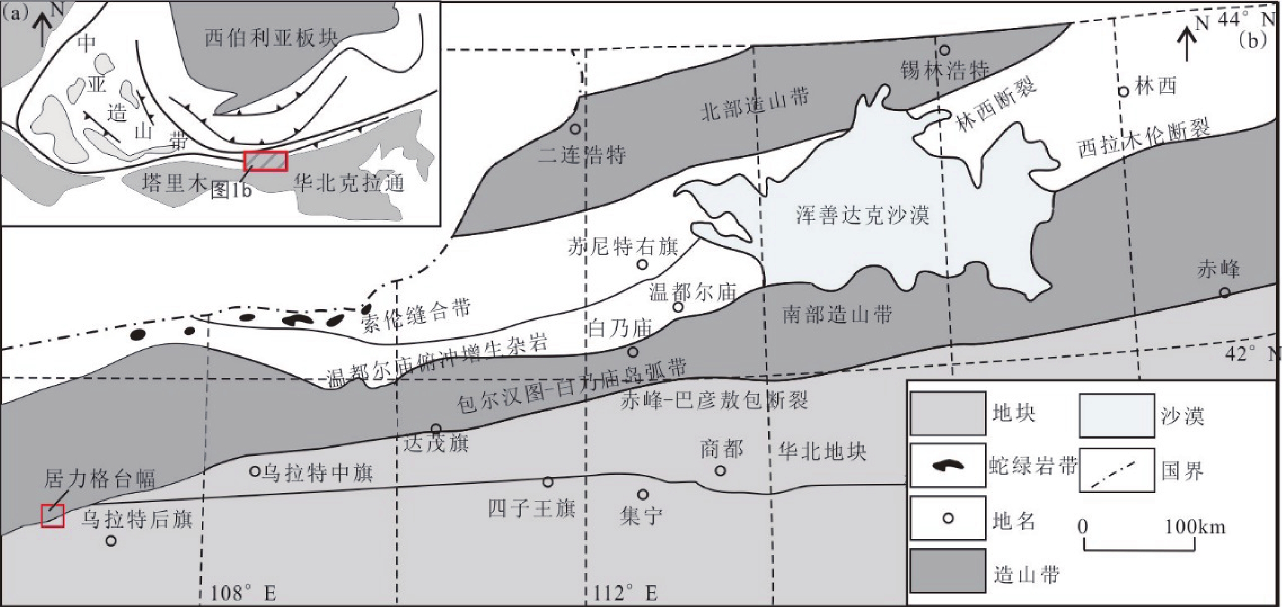
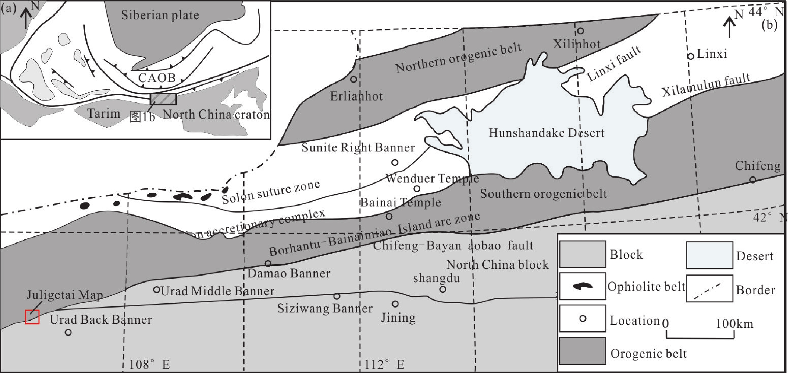
图 1 内蒙古狼山地区大地构造位置图(a)及居力格台幅位置示意(b)(据Wang ZZ et al.,2015修改)
1. Geotectonic location (a) of the Langshan area, Inner Mongolia, and location of the Juligetai map-sheet (b) (modified from Wang ZZ et al., 2015)
表 1 数据库(集)元数据简表
条目 描述 数据库(集)名称 内蒙古居力格台幅1∶50 000地质图数据库 数据库(集)作者 沉积岩类:刘 洋,中国地质调查局天津地质调查中心
火山岩类:郭 硕,中国地质调查局天津地质调查中心
岩浆岩类:滕学建,中国地质调查局天津地质调查中心
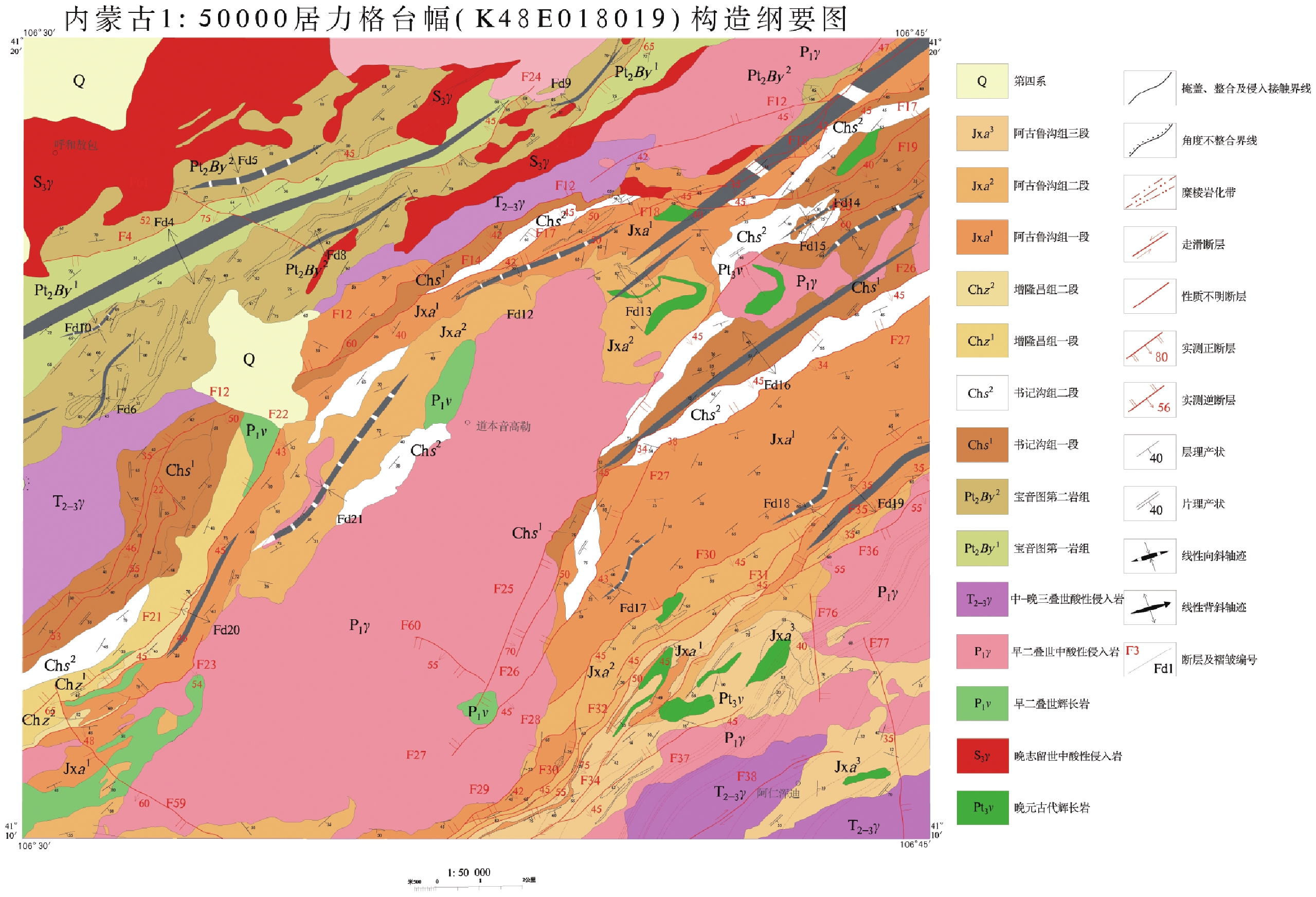
变质岩类:滕 飞,中国地质调查局天津地质调查中心数据时间范围 2014—2016年 地理区域 经纬度:东经106°30′~106°45′,北纬41°10′~41°20′ 数据格式 MapGIS 数据量 106 MB 数据服务系统网址 http://dcc.cgs.gov.cn 基金项目 中国地质调查局地质调查项目“特殊地质地貌区填图试点” (项目编号:12120113056300)资助 语种 中文 数据库(集)组成 居力格台幅1∶50 000地质图数据库由主图和图外整饰两部分组成。主图内容包括第四系、沉积岩、火山岩、侵入岩、构造形迹、地质界线、产状、各类代号等;图外整饰内容包括接图表、地层综合柱状图、侵入岩填图单位、图切剖面、构造纲要图、大地构造位置图、图例、责任表等。整体数据内容包含有3个非正式填图单位,12个正式填图单位、3期岩浆事件和3期构造变形,以及120个岩石化学分析数据,13个样品的锆石U-Pb年龄数据 表 2 野外数据实体表
PRB过程 实体名 实体编码 实体数 单位 描述 野外数据采集 地质路线 ROUTE 154 条 顺序号,图幅编号,图幅名称,路线号,日期,天气,路线描述,目的任务,手图编号,记录者,同行者,摄像者,路线总结 地质点(P) GPOINT 1094 个 顺序号,图幅编号,路线号,地质点号,经度,纬度,高程,纵坐标,横坐标,地理位置,露头性质,点性,微地貌,风化程度,岩性A,岩性B,岩性C,岩性代码A,岩性代码B,岩性代码C,地层单位A,地层单位B,地层单位C,接触关系AB,接触关系BC,接触关系AC,描述,国际标准编码,日期,地质点描述文件名 分段路线(R) ROUTING 3154 条 顺序号,路线号,地质点号,点间编号,填图单位,日期,分段路线距离,点间累计距离,路线方向,备注,分段路线描述文件名 点间界线(B) BOUNDARY 2963 条 顺序号,图幅编号,路线号,地质点号,B编号,R编号,纵坐标,横坐标,高程,经度,纬度,界线右边地质体,界线左边地质体,界线类型,走向,倾向,倾角,接触关系,国际标准编码,备注,日期,点间界线描述文件名 产状 ATTITUDE 877 个 顺序号,图幅编号,路线号,地质点号,点间编号,产状编号,产状类型,纵坐标,横坐标,经度,纬度,高程,走向,倾向,倾角,国际标准编码,日期 样品 SAMPLE 449 件 顺序号,图幅编号,路线号,地质点号,点间编号,野外编号,样品类别,纵坐标,横坐标,经度,纬度,地理位置,采样深度cm,样品重量kg,袋数,块数,采样人,日期,填图单位,野外原始定名,室内鉴定定名,送样单位,分析要求,备注,国际标准编码 素描 SKETCH 134 个 顺序号,图幅编号,路线号,地质点号,点间编号,素描编号,纵坐标,横坐标,经度,纬度,素描名称,比例尺,素描说明,国际标准编码,日期,素描图文件夹 照片 PHOTO 1990 个 顺序号,图幅编号,路线号,地质点号,点间编号,照片编号,纵坐标,横坐标,经度,纬度,描述内容,照片序号,镜头方向,国际标准编码,日期 表 3 1∶50000居力格台幅地质图空间数据库要素类和对象类一览表
数据类型 名称 标准编码 说明 基本要素类 地质体面实体 _GEOPOLYGON.WP 实体数:611个 地质(界)线 _GEOLINE.WL 实体数:1624个 矿产地 _MINERAL_PNT.WT 实体数:7个 产状 _ATTITUDE.WT 实体数:877个 同位素测年 _ISOTOPE.WT 实体数:13个 对象类 沉积(火山)岩岩石地层单位 _Strata 包括中–新元古界渣尔泰山群书记沟组一段(Chs1)、二段(Chs2),增隆昌组一段(Chz1)、二段(Chz2),阿古鲁沟组一段(Jxa1)、二段(Jxa2)、三段(Jxa3);白垩系乌兰苏海组(K2w)、及第四系等共计10个地层单位 侵入岩岩石年代单位 _Intru _Litho_Chrono 新元古代辉长岩;志留纪二长花岗岩、花岗伟晶岩;早二叠世辉长岩、角闪闪长岩、中细粒石英闪长岩、细粒石英闪长岩、含角闪石黑云母花岗闪长岩、黑云母花岗闪长岩、花岗闪长岩、似斑状二长花岗岩、黑云母二长花岗岩;晚二叠世黑云母二长花岗岩、中粒二长花岗岩;中三叠世二长花岗岩;晚三叠世似斑状二长花岗岩,共计16个单位 脉岩 _Dike_Object 脉岩共计8类 综合要素类 标准图框 _MAP_FRAME.WL 标准图框内图框4条线,属性相同 构造变形带 _TECTZONE.WP 韧性剪切带 蚀变带 _ALTERATION_POLYGON.WP 中—新元古代渣尔泰山群角岩化蚀变带及褐铁矿化蚀变带 独立要素类 接图表 SelfJtb 综合柱状图 Column_sec 图切剖面 Cutting_profile 图例 Legend 表 4 内蒙古居力格台幅1∶50 000地质图空间数据库数据属性表
数据类型 名称 标准编码 数据项属性 基本要素类 地质体面实体 _GeoPolygon 地质体面实体标识号,地质体面实体类型代码,地质体面实体名称,地质体面实体时代,地质体面实体下限年龄值,地质体面实体上限年龄值,子类型标识 地质(界)线 _GeoLine 要素标识号,地质界线代码,地质界线类型,界线左侧地质体代号,界线右侧地质体代号,界面走向,界面倾向,界面倾角,子类型标识 产状 _Attitude 要素标识号,产状类型名称代码,产状类型名称,走向,倾向,倾角,子类型标识 样品 _Sample 要素标识号,样品编号,样品类型代码,样品类型名称,样品岩石名称,子类型标识 照片 _Photograph 要素标识号,照片编号,照片题目,照片说明,子类型标识 素描 _Sketch 要素标识号,素描编号,素描题目,素描说明,子类型标识 化石 _Fossil 要素标识号,化石样品编号,化石所属生物门类,化石属或种名,化石产出层位,含化石地层单位代号,化石时代,子类型标识 同位素测年 _Isotope 要素标识号,样品编号,样品名称,年龄测定方法,测定年龄,被测定出地质体单位及代号,测定分析单位,测定分析日期,子类型标识 火山口 _Crater 要素标识号,火山口类型,火山口名称,火山口大小,火山口产出的地质体单位及代号,火山口岩石类型,火山口形成时代,子类型标识 基本要素类 泉 _Spring 要素标识号,泉类型代码,泉类型名称,泉水流量,泉水温度,泉的地质体单位及代号,子类型标识 河、湖、海、水库岸线 _Line_Geography 要素标识号,图元类型,图元名称,子类型标识 综合要素类 构造变形带 _Tectzone 要素标识号,变形带代码,变形带类型名称,变形带岩石名称,变形带组构特征,变形带力学特征,形成时代,活动期次,含矿性,子类型标 蚀变带(面) _Alteration_Polygon 要素标识号,蚀变类型名称代码,蚀变类型名称,蚀变矿物组合及含量,含矿性,被蚀变的地质体代号,子类型标 火山岩相带 _Volca_Facies 要素标识号,火山岩岩相类型及代码,产出的地层单位及代号,火山岩相岩石类型,岩石结构,岩石构造,流面产状,流线产状,形成时代,含矿性,子类型标识 标准图框(内图框) _Map_Frame 图名,图幅代号,比例尺,坐标系统,高程系统,左经度,下纬度,图形单位 对象类 沉积(火山)岩岩石地层单位 _Strata 要素分类,地层单位名称,地层单位符号,地层单位时代,岩石组合名称,岩石组合主体颜色,岩层主要沉积构造,生物化石带或生物组合,地层厚度,含矿性,子类型标识 侵入岩岩石年代单位 _Intru_Litho_Chrono 要素分类,岩体填图单位名称,岩体填图单位符号,岩石名称(岩性),岩石颜色,岩石结构,岩石构造,岩相,主要矿物及含量,次要矿物及含量,与围岩接触关系,围岩时代,与围岩接触面走向,与围岩接触面倾向,与围岩接触面倾角,流面产状,流线产状,形成时代,含矿性,子类型标识 断层 _Fault 要素分类代码,断层类型,断层名称,断层编号,断层性质,断层上盘地质体代号,断层下盘地质体代号,断层破碎带宽度,断层走向,断层倾向,断层面倾角,估计断距,断层形成时代,活动期次,子类型标识 脉岩(面) _Dike_Object 脉岩分类代码,脉岩名称,脉岩符号,岩性,颜色,结构,构造,主要矿物及含量,次要矿物及含量,与围岩接触面走向,与围岩接触面倾向,与围岩接触面倾角,形成时代,含矿性,子类型标识 非正式地层单位 _Inf_Strata 要素分类代码,非正式地层单位代码,岩性,岩石结构构造,所含生物化石带或生物组合,出露宽度或厚度,含矿性,所在地层单位符号,子类型标识 面状水域 _Water_Region 要素分类代码,图元类型,图元名称,图元特征,子类型标识 图幅基本信息 _Sheet_Mapinfo 地形图编号,图名,比例尺,坐标系统,高程系统,左经度,右经度,上纬度,下纬度,成图方法,调查单位,图幅验收单位,评分等级,完成时间,出版时间,资料来源,数据采集日期 表 5 内蒙古居力格台幅侵入岩时间序列表
时代 填图单位 主体岩性 主要分布位置 面积/km2 产状 主要接触关系 同位素年龄/Ma 构造背景 三叠纪 晚三叠世 zxπηγT3 中细粒似斑状二长花岗岩 恩格仁乌日腾 9.11 岩株 侵入zcβηγP1、渣尔泰山群 230.2±1.5 伸展 后造山 247.3±1.4 中三叠世 zxηγT2 中细粒二长花岗岩 昂格日–布敦毛德、霍布阿木–巴拉更伊高勒 118.83 岩基 被xβηγT2侵入 237.8±2.4 二叠纪 晚二叠世 xγδP1 灰白色中细粒花岗闪长岩 乌兰浑迪–陶布格仁高勒一带 4 岩枝 侵入xδC1中 268.0±1.1 挤压 大陆边缘弧 早二叠世 zηγP2 灰白色中粒二长花岗岩 那仁塞尔南部、瑙滚额热格高勒–敦德萨拉 15 岩枝 侵入zxδοP1中 258.24±0.75 zcβηγP1 灰白色中粗粒黑云母二长
花岗岩塔黑勒图–恩格日尔一带北部(韧性剪切带) 6 岩枝 被zxπηγT1侵入 269.92±0.85 zxπβηγP1 灰白色、肉红色中细粒似斑状二长花岗岩 敖包伊高勒–巴润贵力森乃高勒一带 49 岩株 侵入zxβγδP1 288.58±0.99 zβγδP1 灰色中粒黑云母花岗闪长岩 呼和陶勒盖高勒附近 0.6 岩滴 侵入zxβγδP1 278.05±0.69 278.07±0.66 x(zx)δοP1 灰白色细粒、中细粒石英闪长岩 阿日音珠斯郎南部、哈日陶勒盖–推木日图、毛浩日尧音高勒–居力格台 35.2 岩枝 侵入宝音图岩群、渣尔泰山群、zxδοP1 275.25±0.68 270.10±0.74 zxδψP1 灰色中细粒角闪闪长岩 阿伦珠斯朗一带 3.6 岩枝 侵入渣尔泰山群中 272±2 志留纪 晚志留世 zxηγS3 灰红色中细粒二长花岗岩 乌兰敖包–善达;呼和陶勒盖 124 岩基 侵入宝音图岩群中;被γδC1侵入 420.8±4.4 挤压 同造山(拼贴) 新元古代 νPt3 灰黑色中细粒辉长岩 德勒–好勒包 2 岩枝或岩脉 侵入渣尔泰山群之中 850.6±2.9 伸展 注:zx—中细粒;x—细粒;z—中粒;zc—中粗粒。 1 Metadata Table of Database (Dataset)
Items Description Database (dataset) name 1∶50 000 Geological Map Database of the Juligetai Map-Sheet, Inner Mongolia Database (dataset)
authorsSedimentary rocks: Liu Yang, Tianjin Center, China Geological Survey
Volcanic rocks: Guo Shuo, Tianjin Center, China Geological Survey
Magmatic rocks: Teng Xuejian, Tianjin Center, China Geological Survey
Metamorphic rocks: Teng Fei, Tianjin Center, China Geological SurveyData acquisition time 2014 – 2016 Geographic area 106°30′ – 106°45′ E,41°10′ – 41°20′ N Data format MapGIS Data size 106 MB Data service system URL http://dcc.cgs.gov.cn Fund project Funded by China Geological Survey project titled ‘Pilot Mapping of Special Geological and Geomorphological Areas’ (Project No.: 12120113056300) Language Chinese Database (dataset) composition The 1∶50 000 Geological Map Database of the Juligetai Map-Sheet consists of two parts: the master map and outer finishing. The master map includes Quaternary, sedimentary rock, volcanic rocks, intrusives, structural features, geological boundary, attitude and various codes. The outer finishing includes an index map, stratigraphic columnar section, intrusive rock mapping units, cutting profile, structure outline map, geotectonic location, legend and author information. Overall, the map database includes 3 informal mapping units, 12 formal mapping units, 3 periods of magmatic events and deformations, as well as 120 pieces of petrochemical analysis data and the zircon U–Pb age of 13 samples 2 Field data entity table
PRB process Entity name Entity code Number of entities Description Field
data collectionGeological route ROUTE 154 Sequence number, map-sheet number, map-sheet name, route number, date, weather, route description, task, hand map number, recorder, companion, photographer, route summary Geological point (P) GPOINT 1094 Sequence number, map-sheet number, route number, geological point number, longitude, latitude, elevation, vertical coordinates, horizontal coordinates, geographical location, outcrop property, point nature, micro-geomorphology, weathering degree, lithology A, lithology B, lithology C, lithology code A, lithology code B, lithology code C, stratigraphic unit A, stratigraphic unit B, stratigraphic unit C, contact relation AB, contact relation BC, contact relation AC, description, International Standard Code, date, geological point description file name Field
data
collectionRouting (R) ROUTING 3154 Sequence number, route number, geological point number, inter-point number, mapping unit, date, routing distance, cumulative distance between points, route direction, note, routing description file name Inter-point boundary (B) BOUNDARY 2963 Sequence number, map-sheet number, route number, geological point number, B number, R number, vertical coordinates, horizontal coordinates, elevation, longitude, latitude, geobody on the right side of the boundary, geobody on the left side of the boundary, boundary line type, strike, dip, dip angle, contact relation, International Standard Code, note, date, inter-point boundary description file name Attitude ATTITUDE 877 Sequence number, map-sheet number, route number, geological point number, inter-point number, attitude number, attitude type, vertical coordinates, horizontal coordinates, longitude, latitude, elevation, strike, dip, dip angle, International Standard Code, date Sample SAMPLE 449 Sequence number, map-sheet number, route number, geological point number, inter-point number, field number, sample type, vertical coordinates, horizontal coordinates, longitude, latitude, geographical location, sampling depth (cm), sample weight (kg), number of bags, number of pieces, sample collector, date, mapping unit, original naming in field, naming based on indoor identification, unit sending sample, analysis requirements, note, International Standard Code Sketch SKETCH 134 Sequence number, map-sheet number, route number, geological point number, inter-point number, sketch number, vertical coordinates, horizontal coordinates, longitude, latitude, sketch name, scale, sketch description, International Standard Code, date, sketch folder Photo PHOTO 1990 Sequence number, map-sheet number, route number, geological point number, inter-point number, sample code, vertical coordinates, horizontal coordinates, longitude, latitude, description, photo serial number, lens direction, International Standard Code, date 3 Feature and object class of 1∶50 000 geological map database of the Juligetai map-sheet
Data type Name Standard code Description Basic
feature classGeological polygon _GEOPOLYGON.WP Number of entities: 611 Geological boundary line _GEOLINE.WL Number of entities: 1624 Mineral area _MINERAL_PNT.WT Number of entities: 7 Attitude _ATTITUDE.WT Number of entities: 877 Isotope dating _ISOTOPE.WT Number of entities: 13 Object class Sedimentary (volcanic) rock lithostratigraphic unit _Strata 10 stratigraphic units including the first member (Chs1) and second member (Chs2) of the Shujigou Formation, the first member (Chz1) and second member (Chz2) of the Zenglongchang Formation, and the first member (Jxa1), second member (Jxa2) and third member (Jxa3) of the Agulugou Formation of the Middle-Neoproterozoic Zhaertaishan Group; Cretaceous Wulansuhai Formation (K2w) and the Quaternary System Intrusive rock lithochronological unit _Intru _Litho_Chrono A total of 16 units including Neoproterozoic gabbro; Silurian adamellite, granite pegmatite; Early Permian gabbro, hornblende diorite, medium-fine-grained quartz diorite, fine-grained quartz diorite, hornblende-bearing biotite granodiorite, biotite granodiorite, granodiorite, porphyritic monzonitic granite, biotite monzonitic granite; Late Permian biotite monzonitic granite and medium-grained monzonitic granite; Middle Triassic adamellite; Late Triassic porphyritic monzonitic granite Dike _Dike_Object 8 types of dikes Complex class Standard frame _MAP_FRAME.WL 4 lines in the standard frame with the same attributes Tectonic deformation zone _TECTZONE.WP Ductile shear zone Alteration polygon _ALTERATION_POLYGON.WP Meso-Neoproterozoichornfelsed alteration polygon and Limonitization alteration polygon of the Zhaertaishan Group Independent feature class Index map SelfJtb Columnar section Column_sec Cutting profile Cutting_profile Legend Legend 4 Data attributes of 1: 50 000 geological map spatial database of Juligetai map-sheet, Inner Mongolia
Data type Name Standard code Attribute of data item Basic
feature
classGeological polygon _GeoPolygon Geological polygon identification number, geological code, geological polygon name, geological polygon age, lower age limit of geological polygon, upper age limit of geological polygon, subtype identification Geological (boundary)
line_GeoLine Feature identification number, geological boundary line code, boundary name, geobody code on the left side of the boundary, geobody code on the right side of the boundary, strike, dip direction, dip angle, subtype identification Attitude _Attitude Feature identification number, attitude type code, attitude name, strike, dip direction, dip angle, subtype identification Sample _Sample Feature identification number, sample code, sample type code, sample name, rock name, subtype identification Photograph _Photograph Feature identification number, sample code, photo title, photo note, subtype identification Sketch _Sketch Feature identification number, sample code, sketch title, sketch note, subtype identification Fossil _Fossil Feature identification number, fossil sample code, biological category of fossil, genus or species, bed, code of fossil-bearing lithostratigraphic unit, era, subtype identification Isotope _Isotope Feature identification number, sample code, sample name, age measuring method, age, unit and code of measured geobody, measure and analysis unit, measure and analysis date, subtype identification Crater _Crater Feature identification number, crater type, crater name, crater size, unit and code of geobody produced at the crater, crater rocktype, crater era, subtype identification Spring _Spring Feature identification number, spring code, spring name, spring runoff, temperature, geobody code, subtype identification River, lake, sea and water coastline _Line_Geography Feature identification number, feature type, feature name, subtype identification Complex class Tectonic deformation zone _Tectzone Feature identification number, feature type, feature name, deformation name, fabric character, mechanics, era, movement period, commodities, subtype identification Alteration polygon _Alteration_Polygon Feature identification number, feature type, alteration type, association, commodities, altered geobody code, subtype identification Volcanic facies _Volca_Facies Feature identification number, feature type, stratigraphic unit, rock type, rock texture, rock structure, flow plane attitude, flow line attitude, era, commodities, subtype identification Map frame _Map_Frame Map name, sheet code, scale, coordinate system, height system, left longitude, lower longitude, coordinates unit Object Class Sedimentary (volcanic) rock lithostratigraphic unit _Strata Feature type identification, stratigraphic unit name, stratigraphic unit code, stratigraphic unit era, rock association name, rock association color, sedimentary structure, biological assemblage zone, stratigraphic thickness, commodities, subtype identification Intrusive rock lithochronological unit _Intru_Litho_Chrono Feature type, intrusive body name, intrusive body code, rock name, color, rock texture, rock structure, rock phases, primary minerals and content, secondary minerals and content, contact relation with wall-rock, wall-rock era, attitude of wall-rock contact surface (strike, dip direction, dip angle), flow plane attitude, flow line attitude, formative era, commodities, subtype identification Fault _Fault Feature type, fault type, fault name, fault code, fault character, fault hanging wall geobody code, fault footwall geobody code, fault fracture zone width, fault strike, fault dip, fault dip angle, estimated fault distance, formative era of fault, movement period, subtype identification Dike _Dike_Object Feature type, dike name, dike code, dike lithology, dike color, texture, structure, primary minerals and content, secondary minerals and content, strike, dip direction, dip angle, formative era, commodities, subtype identification Informal strata _Inf_Strata Feature type, informal stratigraphic unit code, lithology, rock texture and structure, fossil assemblage, outcrop width or thickness, commodities, stratigraphic unit code, subtype identification Water region _Water_Region Feature type, feature class, feature name, object feature, subtype identification Sheet map information _Sheet_Mapinfo Sheet numbering, sheet name, scale, coordinate system, height system, left longitude, right longitude, upper latitude, lower latitude, mapping method, survey unit, accepting unit, grade, finished date, publish date, data origin, data acquisition date 5 Time series of the intrusives in Juligetai map-sheet, Inner Mongolia
Era Mapping unit Main lithology Main distribution Area/km2 Attitude Main contact relation Isotopic age/Ma Tectonic setting Triassic Late Triassic zxπηγT3 Medium-fine-grained porphyritic monzonitic granite Engerenwuriteng 9.11 Stock Intruding zcβηγP1,Zhaertaishan Group 230.2±1.5
247.3±1.4Extension Post-orogeny Middle Triassic zxηγT2 Medium-fine-grained monzonitic granite Anggeri – Budunmaude, Huobuamu – Balagengyigaole 118.83 Batholith Intruded by xβηγT2 237.8±2.4 Permian Late Permian xγδP1 Grey-white medium-fine granodiorite Ulanhundi – Taubugerengaole area 4 Apophysis Intruding xδC1 268.0±1.1 Compression Continental margin arc Early Permian zηγP2 Grey-white medium-grained monzonitic granite Southern part of Narensaier, Naoguneregegaole-Dundesala 15 Apophysis Intruding zxδοP1 258.24±0.75 zcβηγP1 Grey-white medium-coarse-grained biotite monzonitic granite Northern part of Taheiletu-Engerier area (ductile shear zone) 6 Apophysis Intruded by zxπηγT1 269.92±0.85 zxπβηγP1 Grey-white meat-red medium-fine grained porphyritic monzonitic granite Aobaoyigole – Barunguilisennaigaole area 49 Stock Intruding zxβγδP1 288.58±0.99 zβγδP1 Grey medium-grained biotite granodiorite Vicinity of Huhetaolegaigaole 0.6 Rock drop Intruding zxβγδP1 278.05±0.69
278.07±0.66x(zx)δοP1 Grey-white fine-grained and medium-fine-grained quartz diorite Southern part of Hariyinzhusilang, Haritaolegai – Tuimuritu, Maohaoriyaoyingaole – Juligetai 35.2 Apophysis Intruding Baoyintu Group and Zhaertaishan Group, zxδοP1 275.25±0.68
270.10±0.74zxδψP1 Grey medium-fine grained hornblende diorite Alunzhusilang area 3.6 Apophysis Intruding Zhaertaishan Group 272 ±2 Silurian Late Silurian zxηγS3 Grey- red medium-fine-grained monzonitic granite Ulan Obo – Shanda; Huhetaolegai 124 Batholith Intruding Baoyintu Group; intruded by γδC1 420.8 ±4.4 Compression Synorogeny (collage) Neoproterozoic νPt3 Grey-black medium-fine-grained gabbro Dele – Haolebao 2 Apophysis or dike Intruding Zhaertaishan Group 850.6±2.9 Extension Note: zx–medium-fine grained; x–fine-grained; z–medium-grained; zc–medium-coarse-grained. -
[1] Allen M B, Windley B F, Zhang C. 1993. Palaeozoic collisional tectonics and magmatism of the Chinese Tien Shan, Central Asia[J]. Tectonophysics, 220(1–4): 89−115.
[2] Allen M B, Engor A M C, Natalin B A. 1995. Junggar, Turfan and Alakol basins as Late Permian to Early Triassic extensional structures in a sinistral shear zone in the Altaid orogenic collage. Central Asia[J]. Journal of the Geological Society (London), 152(2): 32−338. http://www.wanfangdata.com.cn/details/detail.do?_type=perio&id=d93ec7e7a85de5d3e1296212feefd909
[3] Coleman R G. 1989. Continental growth of Northwest China[J]. Tectonics, 8(3): 621−635. doi: 10.1029/TC008i003p00621
[4] Gao J, Li M S, Xiao X C, Tang Y Q, He G Q. 1998. Paleozoic tectonic evolution of the Tianshan orogen, northwestern China[J]. Tectonophysics, 287(1–4): 213−231.
[5] Han B F, He G Q, Wang X C, Guo Z J. 2011. Late Carboniferous collision between the Tarim and Kazakhstan-Yili terranes in the western segment of the South Tian Shan Orogen, Central Asia, and implications for the Northern Xinjiang, western China[J]. Earth Science Reviews, 109: 74−93. doi: 10.1016/j.earscirev.2011.09.001
[6] Jahn B M, Griffin W L and Windley B F. 2000. Continental growth in the Phanerozoic: Evidence from Central Asia[J]. Tectonophysics, 328(1): vii–x.
[7] Li Y J, Wang G H, Santosh M., Wang J F, Dong P P, Li H Y 2018. Supra-subduction zone ophiolites from Inner Mongolia, North China: Implications for the tectonic history of the southeastern Central Asian Orogenic Belt[J]. Gondwana Research, 59: 126−143. doi: 10.1016/j.gr.2018.02.018
[8] Li Y J, Wang G H, Santosh M, Wang J F, Dong P P, Li H Y. 2020. Subduction initiation of the SE Paleo-Asian Ocean: Evidence from a well preserved intra-oceanic forearc ophiolite fragment in central Inner Mongolia, North China[J]. Earth and Planetary Science Letters, 535: 116087. doi: 10.1016/j.jpgl.2020.116087
[9] Liu M, Zhang D, Xiong G Q, Zhao H T, Di Y J, Wang Z, Zhou Z G. 2016. Zircon U-Pb age Hf isotope and geochemistry of Carboniferous intrusions from the Langshan area, Inner Mongolia: Petrogenesis and tectonic implications[J]. Journal of Asian Earth Sciences, 120: 139−158. doi: 10.1016/j.jseaes.2016.01.005
[10] Peng R M, Zhai Y S, Li C S, Ripley E M. 2013. The Erbutu Ni-Cu deposit in the Central Asian Orogenic Belt: a Permian magmatic sulfide deposit related to Boninitic magmatism in an arc setting[J]. Economic Geology, 108: 1879−1888. doi: 10.2113/econgeo.108.8.1879
[11] Sengor A M C, Natalin B A, Burtman V S. 1993. Evolution of the Altaid tectonic collage and Palaeozoic crustal growth in the Eurasia[J]. Nature, 364: 299−304. doi: 10.1038/364299a0
[12] Wang X Y, Yuan C, Zhang Y Y, Long X P, Sun M, Wang LX, Soldner J, Lin Z F. 2018. S-type granite from the Gongpoquan arc in the Beishan Orogenic Collage, southern Altaids: Implications for the tectonic transition[J]. Journal of Asian Earth Sciences, 153: 206−222. doi: 10.1016/j.jseaes.2017.07.037
[13] Wang Z Z, Han B F, Feng LX, Liu B. 2015. Geochronology, geochemistry and origins of the Paleozoic-Triassic plutons in the Langshan area, western Inner Mongolia, China[J]. Journal of Asian Earth Sciences, 97: 337−351. doi: 10.1016/j.jseaes.2014.08.005
[14] Windley B F, Allen M B, Zhang C, Zhao Z Y, Wang GR. 1990. Paleozoic accretion and Cenozoic redeformation of the Chinese Tien Shan range, Central Asia[J]. Geology, 18(2): 128−131. doi: 10.1130/0091-7613(1990)018<0128:PAACRO>2.3.CO;2
[15] Windley B F, Alexeiev D, Xiao W J, Kröner A. 2007. Badarch G.Tectonics models for accretion of the Central Asian Orogenic Belt[J]. Journal of the Geological Society, 164: 31−47. doi: 10.1144/0016-76492006-022
[16] Wu T R, He G Q, Zhang C. 1998. On Paleozoic tectonics in the Alxa region, Inner Mongolia, China[J]. Acta Geologica Sinica(English Edition), 72(3): 256−263.
[17] Xiao W J, Windley B F, Badarch G, Sun S, Li J L, Qin K Z, Wang Z H. 2004. Palaeozoic accretionary and convergent tectonics of the southern Altaids: Implications for the growth of Central Asia[J]. Journal of the Geological Society, 161(3): 339−342. doi: 10.1144/0016-764903-165
[18] Xiao W J, Mao Q G, Windley B F, Han C M, Qu J F, Zhang J E, Ao S J, Guo Q Q, Cleven N R, Lin S F, Shan Y H, Li J L. 2010. Paleozoic multiple accretionary and collisional processes of the Beishan orogenic collage[J]. American Journal of Science, 310: 1553−1594. doi: 10.2475/10.2010.12
[19] Xu B, Charvet J, Chen Y, Zhao P, Shi G Z. 2013. Middle Paleozoic convergent orogenic belts in western Inner Mongolia (China): framework, kinematics, geochronology and implications for tectonic evolution of the Central Asian Orogenic Belt[J]. Gondwana Research, 23: 1342−1364. doi: 10.1016/j.gr.2012.05.015
[20] Xu Z, Han B F, Ren R, Zhou Y Z, Zhang L, Chen J F, Su L, Li X H, Liu D Y. 2012. Ultramafic-mafic mélange, island arc and post-collisional intrusions in the Mayile Mountain, West Junggar, China: implications for Paleozoic intraoceanic subduction-accretion process[J]. Lithos, 132–133: 141−161.
[21] Yuan Y, Zong K Q, He Z Y, Klemd R, Jiang H Y, Zhang W, Liu Y S, Hu Z C, Zhang Z M. 2018. Geochemical evidence for Paleozoic crustal growth and tectonic conversion in the Northern Beishan Orogenic Belt, southern Central Asian Orogenic Belt[J]. Lithos, 302–303: 189−202. http://www.wanfangdata.com.cn/details/detail.do?_type=perio&id=65d3127ae450b6fb3fbcbe83e1cb9f19
[22] Zhang W, Jian P, Kröner A, S hi, Y R. 2013. Magmatic and metamorphic development of an early to mid-Paleozoic continental margin arc in the southernmost Central Asian Orogenic Belt, Inner Mongolia, China[J]. Journal of Asian Earth Sciences, 72: 63−74. doi: 10.1016/j.jseaes.2012.05.025
[23] Zhang X H, Gao Y L, Wang Z J, Liu H, Ma Y G. 2012. Carboniferous appinitic intrusions from the northern North China craton: geochemistry, petrogenesis and tectonic implications[J]. Journal of the Geological Society, 169(3): 337−351. doi: 10.1144/0016-76492011-062
[24] Zheng R G, Xiao W J, Li J Y, Wu T R, Zhang W. 2018. A Silurian-early Devonian slab window in the southern Central Asian Orogenic Belt: Evidence from high-Mg diorites, adakites and granitoids in the western Central Beishan region, NW China[J]. Journal of Asian Earth Sciences, 153: 75−99. doi: 10.1016/j.jseaes.2016.12.008
[25] 白瑾. 2003. 造山带构造样式的恢复及其构造环境意义[J]. 地质调查与研究, 6(1): 38−44. doi: 10.3969/j.issn.1672-4135.2003.01.007 [26] 冯丽霞, 张志诚, 韩宝福, 任荣, 李建锋, 苏犁. 2013. 内蒙古达茂旗花岗岩类 LA–ICP–MS 锆石 U–Pb 年龄及其地质意义[J]. 地质通报, 32(11): 1737−1748. doi: 10.3969/j.issn.1671-2552.2013.11.006 [27] 刘烨. 2012. 内蒙古东升庙地区花岗片麻岩和侵入岩的地球化学、年代学特征及构造意义[D].兰州: 兰州大学博士学位论文. [28] 刘洋, 郭硕, 滕学建, 滕飞. 2020. 内蒙古居力格台幅 1∶50 000 地质图数据库[DB/OL]. 地质科学数据出版系统. (2020-06-30). DOI: 10.35080/data.A.2020.P9. [29] 毛晓长. 2018. 2018年全国区域地质调查优秀图幅展评会召开[J]. 中国地质, 45(S2): 93. doi: 10.12029/gc2018S211 [30] 内蒙古自治区第一区域地质调查队. 1982. 1∶20万区域地质矿产调查报告(三道桥幅)[R]. [31] 滕学建, 田健, 刘洋, 张永, 滕飞, 段霄龙. 2019. 内蒙古狼山地区早志留世石英闪长岩体的厘定及其地质意义[J]. 地球科学, 44(4): 1236−1247. http://www.wanfangdata.com.cn/details/detail.do?_type=perio&id=dqkx201904013 [32] 田健, 滕学建, 刘洋, 滕飞, 何鹏, 郭硕, 王文龙. 2018. 内蒙古狼山地区早石炭世角闪辉长岩、花岗闪长岩的岩石成因及构造意义[J]. 岩石矿物学杂志, 37(5): 60−76. http://www.wanfangdata.com.cn/details/detail.do?_type=perio&id=yskwxzz201805004 [33] 王树庆, 胡晓佳, 赵华雷. 2019. 内蒙古苏左旗洪格尔地区新发现晚石炭世碱性花岗岩[J]. 地质调查与研究, 42(2): 81−85. doi: 10.3969/j.issn.1672-4135.2019.02.001 [34] 吴飞, 张拴宏, 赵越, 叶浩. 2014. 华北地块北缘内蒙古固阳地区早二叠世岩体的侵位深度及其构造意义[J]. 中国地质, 41(3): 824−837. doi: 10.3969/j.issn.1000-3657.2014.03.011 [35] 张维, 简平. 2012. 华北北缘固阳二叠纪闪长岩-石英闪长岩-英云闪长岩套 HSRIMP 年代学[J]. 中国地质, 39(6): 1593−1603. doi: 10.3969/j.issn.1000-3657.2012.06.009 [36] 赵闯, 苏旭亮, 薛斌, 程东江, 史兴俊, 宋涛涛, 张阔. 2020. 内蒙古西部苦楚乌拉-英巴地区花岗岩锆石U–Pb定年及地球化学特征[J/OL]. 中国地质, 1–22 [2020-06-02]. [37] 赵磊, 牛宝贵, 徐芹芹, 杨亚琦. 2019. 新疆东准噶尔卡拉麦里蛇绿岩带两侧志留—石炭系沉积和构造特征分析及其意义[J]. 中国地质, 46(3): 615−628. doi: 10.12029/gc20190312 [1] Allen MB, Windley BF, Zhang C. 1993. Palaeozoic collisional tectonics and magmatism of the Chinese Tien Shan, Central Asia[J]. Tectonophysics, 220(1–4): 89−115. [2] Allen MB, Engor AMC, Natalin BA. 1995. Junggar, Turfan and Alakol basins as Late Permian to Early Triassic extensional structures in a sinistral shear zone in the Altaid orogenic collage. Central Asia[J]. Journal of the Geological Society (London), 152(2): 32−338. http://www.wanfangdata.com.cn/details/detail.do?_type=perio&id=d93ec7e7a85de5d3e1296212feefd909 [3] Bai Jin. 2003. Recovery of structural styles of orogenic belt and its tectonic environmental significance[J]. Geological survey and research, 6(1): 38−44, 51 (in Chinese with English abstract). [4] Coleman RG. 1989. Continental growth of Northwest China[J]. Tectonics, 8(3): 621−635. doi: 10.1029/TC008i003p00621 [5] Feng Lixia, Zhang Zhicheng, Han Baofu, Ren Rong, Li Jianfeng, Su Li. 2013. LA-ICP-MS zircon U–Pb ages of granitoids in Darhan Muminggan Joint Banner, Inner Mongolia, and their geological significance[J]. Geological Bulletin of China, 32(11): 1737−1748 (in Chinese with English abstract). [6] Gao J, Li MS, Xiao XC, Tang YQ, He GQ. 1998. Paleozoic tectonic evolution of the Tianshan orogen, northwestern China[J]. Tectonophysics, 287(1–4): 213−231. [7] Han BF, He GQ, Wang XC, Guo ZJ. 2011. Late Carboniferous collision between the Tarim and Kazakhstan-Yili terranes in the western segment of the South Tian Shan Orogen, Central Asia, and implications for the Northern Xinjiang, western China[J]. Earth Science Reviews, 109: 74−93. doi: 10.1016/j.earscirev.2011.09.001 [8] Jahn BM, Griffin WL, Windley BF. 2000. Continental growth in the Phanerozoic: Evidence from Central Asia[J]. Tectonophysics, 328(1): vii−x. [9] Li YJ, Wang GH, Santosh M., Wang JF, Dong PP, Li HY 2018. Supra-subduction zone ophiolites from Inner Mongolia, North China: Implications for the tectonic history of the southeastern Central Asian Orogenic Belt[J]. Gondwana Research, 59: 126−143. doi: 10.1016/j.gr.2018.02.018 [10] Li YJ, Wang GH, Santosh M, Wang JF, Dong PP, Li HY. 2020. Subduction initiation of the SE Paleo-Asian Ocean: Evidence from a well preserved intra-oceanic forearc ophiolite fragment in central Inner Mongolia, North China[J]. Earth and Planetary Science Letters, 535: 116087. doi: 10.1016/j.jpgl.2020.116087 [11] Liu M, Zhang D, Xiong GQ, Zhao HT, Di YJ, Wang Z, Zhou ZG. 2016. Zircon U–Pb age Hf isotope and geochemistry of Carboniferous intrusions from the Langshan area, Inner Mongolia: Petrogenesis and tectonic implications[J]. Journal of Asian Earth Sciences, 120: 139−158. doi: 10.1016/j.jseaes.2016.01.005 [12] Liu Ye. 2012. Geochemical and Chronological Characteristics of the Granitic Gneisses and Intrusive Rocks from Dongshengmiao Region, Inner Mongolia and Their Tectonic Implications[D]. Lanzhou: Doctoral dissertation of Lanzhou University (in Chinese with English abstract). [13] Liu Yang, GuoShuo, Teng Xuejian, Teng Fei. 2020. 1∶50 000 Geological Map Database of the Juligetai Map-sheet, Inner Mongolia[DB/OL]. Geoscientific Data & Discovery Publishing System. (2020-06-30). DOI: 10.35080/data.A.2020.P9. [14] Mao Xiaochang. 2018. 2018 National exhibition and evaluation conference on excellent maps of regional geological survey[J]. Geology in China, 45(S2): 119−120 (in Chinese with English abstract). http://www.wanfangdata.com.cn/details/detail.do?_type=perio&id=zgdizhi2018z2012 [15] Peng RM, Zhai YS, Li CS, Ripley EM. 2013. The Erbutu Ni–Cu deposit in the Central Asian Orogenic Belt: a Permian magmatic sulfide deposit related to Boninitic magmatism in an arc setting[J]. Economic Geology, 108: 1879−1888. doi: 10.2113/econgeo.108.8.1879 [16] Sengor AMC, Natalin BA, Burtman VS. 1993. Evolution of the Altaid tectonic collage and Palaeozoic crustal growth in the Eurasia[J]. Nature, 364: 299−304. doi: 10.1038/364299a0 [17] Teng Xuejian, Tian Jian, Liu Yang, Zhang Yong, Teng Fei, Duan Xiaolong. 2019. Definition and Geological Significance of Early Silurian Quartz Diorite Pluton in Langshan area, Inner Mongolia[J]. Earth Science, 44(4): 1236−1247 (in Chinese with English abstract). http://www.wanfangdata.com.cn/details/detail.do?_type=perio&id=dqkx201904013 [18] The first regional geological survey team of Inner Mongolia. 1982. 1∶200 000 regional geological and mineral survey report (Sandaoqiao Map Sheet)[R]. Inner Mongolia Autonomous Region(in Chinese). [19] Tian Jian, Teng Xuejian, Liu Yang, Teng Fei, Guo Shuo, He Peng, Wang Wenlong. Duan Xiaolong 2018. Petrogenesis and tectonic significance of the Early Carboniferous hornblendegabbro and granodiorite in Langshan area, Inner Mongolia[J]. Acta Petrologica Et Mineralogica, 37(5): 754−770 (in Chinese with English abstract). [20] Wang Shuqing, Hu Xiaojia, Zhao Hualei. 2019. New discovery of Late Carboniferous alkaline granite in the Honggeer area, Sonid Zuoqi, Inner Mongolia[J]. Geological survey and research, 42(2): 81−85 (in Chinese with English abstract). [21] Wang XY, Yuan C, Zhang YY, Long XP, Sun M, Wang LX, Soldner J, Lin Z F. 2018. S-type granite from the Gongpoquan arc in the Beishan Orogenic Collage, southern Altaids: Implications for the tectonic transition[J]. Journal of Asian Earth Sciences, 153: 206−222. doi: 10.1016/j.jseaes.2017.07.037 [22] Wang ZZ, Han BF, Feng LX, Liu B. 2015. Geochronology, geochemistry and origins of the Paleozoic–Triassic plutons in the Langshan area, western Inner Mongolia, China[J]. Journal of Asian Earth Sciences, 97: 337−351. doi: 10.1016/j.jseaes.2014.08.005 [23] Windley BF, Allen MB, Zhang C, Zhao ZY, Wang GR. 1990. Paleozoic accretion and Cenozoic redeformation of the Chinese Tien Shan range, Central Asia[J]. Geology, 18(2): 128−131. doi: 10.1130/0091-7613(1990)018<0128:PAACRO>2.3.CO;2 [24] Windley BF, Alexeiev D, Xiao WJ, Kröner A. 2007. Badarch G.Tectonics models for accretion of the Central Asian Orogenic Belt[J]. Journal of the Geological Society, 164: 31−47. doi: 10.1144/0016-76492006-022 [25] Wu Fei, Zhang Shuanghong, Zhao Yue, Ye Hao. 2014. Emplacement depth and tectonic significance of Early Permian pluton in Inner Mongolia Guyang area, northern margin of North China block[J]. Geology in China, 41(3): 824−837 (in Chinese with English abstract). [26] Wu TR, He GQ, Zhang C. 1998. On Paleozoic tectonics in the Alxa region, Inner Mongolia, China[J]. Acta Geologica Sinica, 72(3): 256−263. [27] Xiao WJ, Windley BF, Badarch G, Sun S, Li JL, Qin KZ, Wang ZH. 2004. Palaeozoic accretionary and convergent tectonics of the southern Altaids: Implications for the growth of Central Asia[J]. Journal of the Geological Society, 161(3): 339−342. doi: 10.1144/0016-764903-165 [28] Xiao W J, Mao Q G, Windley B F, Han C M, Qu J F, Zhang J E, Ao S J, Guo Q Q, Cleven N R, Lin S F, Shan Y H, Li J L. 2010. Paleozoic multiple accretionary and collisional processes of the Beishan orogenic collage[J]. American Journal of Science, 310: 1553−1594. doi: 10.2475/10.2010.12 [29] Xu B, Charvet J, Chen Y, Zhao P, Shi GZ. 2013. Middle Paleozoic convergent orogenic belts in western Inner Mongolia (China): framework, kinematics, geochronology and implications for tectonic evolution of the Central Asian Orogenic Belt[J]. Gondwana Research, 23: 1342−1364. doi: 10.1016/j.gr.2012.05.015 [30] Xu Z, Han BF, Ren R, Zhou YZ, Zhang L, Chen JF, Su L, Li XH, Liu DY. 2012. Ultramafic-mafic mélange, island arc and post-collisional intrusions in the Mayile Mountain, West Junggar, China: implications for Paleozoic intraoceanic subduction-accretion process[J]. Lithos, 132–133: 141−161. [31] Yuan Y, Zong K Q, He ZY, Klemd R, Jiang HY, Zhang W, Liu YS, Hu ZC, Zhang ZM. 2018. Geochemical evidence for Paleozoic crustal growth and tectonic conversion in the Northern Beishan Orogenic Belt, southern Central Asian Orogenic Belt[J]. Lithos, 302–303: 189−202. http://www.wanfangdata.com.cn/details/detail.do?_type=perio&id=65d3127ae450b6fb3fbcbe83e1cb9f19 [32] Zhang Wei, Jian Ping. 2012. SHRIMP dating of the Permian Guyang diorite-granodiorite-tonalite suite in the northern margin of the North China Craton[J]. Geology in China, 39(6): 1593−1603 (in Chinese with English abstract). [33] Zhang W, Jian P, Kröner A, Shi YR. 2013. Magmatic and metamorphic development of an early to mid-Paleozoic continental margin arc in the southernmost Central Asian Orogenic Belt, Inner Mongolia, China[J]. Journal of Asian Earth Sciences, 72: 63−74. doi: 10.1016/j.jseaes.2012.05.025 [34] Zhang XH, Gao YL, Wang ZJ, Liu H, Ma YG. 2012. Carboniferous appinitic intrusions from the northern North China craton: geochemistry, petrogenesis and tectonic implications[J]. Journal of the Geological Society, 169(3): 337−351. doi: 10.1144/0016-76492011-062 [35] Zhao Chuang, Su Xuliang, Xue bin, Cheng Dongjiang, Shi Xingjun, song Taotao, Zhang Kuo. 2020. Zircon U-Pb dating and geochemical characteristics of granites in the area of Wula-Yingba, Kuchu, western Inner Mongolia[J/OL]. Geology in China,1–22[2020-06-02] (in Chinese with English abstract). [36] Zhao Lei, Niu Baogui, Xu Qinqin, Yang Yaqi. 2019. An analysis of Silurian- Carboniferous sedimentary and structural characteristics on both sides of Karamaili ophiolitic belt of Xinjiang and its significance[J]. Geology in China, 46(3): 615−628 (in Chinese with English abstract). http://www.wanfangdata.com.cn/details/detail.do?_type=perio&id=zgdizhi201903014 [37] Zheng RG, Xiao WJ, Li JY, Wu TR, Zhang W. 2018. A Silurian-early Devonian slab window in the southern Central Asian Orogenic Belt: Evidence from high-Mg diorites, adakites and granitoids in the western Central Beishan region, NW China[J]. Journal of Asian Earth Sciences, 153: 75−99. doi: 10.1016/j.jseaes.2016.12.008 -
期刊类型引用(14)
1. 谭双,刘晓东,雷勇亮,陈琪,万建军,吴昆明,欧阳平宁,黄宏业. 桂北苗儿山铀矿田铀源分析:来自周缘红盆碎屑锆石的制约. 大地构造与成矿学. 2025(01): 70-89 .  百度学术
百度学术
2. 王珂,吴昆明,朱煜翔,欧阳平宁,黄宏业,范鹏飞,陈琪,谭双,谷勇. 桂东北苗儿山地区上小地加里东期花岗斑岩成因及其与铀成矿关系. 大地构造与成矿学. 2024(03): 580-598 .  百度学术
百度学术
3. XUE Wenhao,LIANG Yayun,LI Xiaofeng,LI Mingyi,XIE Wenbo,PENG Xue,XIA Rui,HE Hongsheng,XIAO Jincheng. The Geology, Fluid Inclusions, and O-S Isotopes of the Mibei Gold Deposit, Hunan Province, Southern China. Acta Geologica Sinica(English Edition). 2024(04): 992-1006 .  必应学术
必应学术
4. 赵子翔,陈琪,王凯兴,孙立强,刘晓东,杨建俊,谭双. 桂北沙子江铀矿床赤铁矿地球化学特征及铀成矿启示. 铀矿地质. 2024(06): 1100-1117 .  百度学术
百度学术
5. 陈剑锋,杜云,熊伊曲,管申进,何红生,周立同,陆文,石金江. 南岭加里东期钨锡矿床成矿机制研究:以湘西南落家冲矿床为例. 岩石学报. 2023(06): 1693-1716 .  百度学术
百度学术
6. 李科甫,朱传庆. 华夏地块花岗岩生热率特征及其对地温场的影响. 石油科学通报. 2023(03): 259-289 .  百度学术
百度学术
7. 李根,方贵聪,冯佐海,黄振男,罗桥花,黄祥林,蒋松林. 桂东北胡家田萤石矿床稀土元素地球化学特征及其指示意义. 桂林理工大学学报. 2023(01): 52-60 .  百度学术
百度学术
8. 贺海洋,王亭亭,唐振平,任烜,侯淡平,香承希,刘毅,黄智. 湖南加里东期花岗岩成因及铀成矿关系. 南华大学学报(自然科学版). 2023(02): 45-53 .  百度学术
百度学术
9. 杜云,田磊,郑正福,陈剑锋,张小强,王敬元,周立同,樊晖,李超. 湘西南落家冲钨锡矿床加里东期成岩成矿年龄的测定:对华南多旋回构造-岩浆活动与成矿作用的启示. 地质通报. 2022(05): 886-902 .  百度学术
百度学术
10. 于玉帅,周云,牛志军,安志辉,刘阿睢. 湖南彭公庙岩体地球化学特征、时代及钨锡成矿潜力. 岩石矿物学杂志. 2022(04): 695-713 .  百度学术
百度学术
11. 田磊,杜云,邹源,刘邦定,张小强,樊晖. 湘西南苗儿山地区水系沉积物地球化学特征及找矿方向. 华南地质. 2021(02): 164-176 .  百度学术
百度学术
12. 李胜苗,田磊,杜云,邹源,樊晖,章靖. 南岭苗儿山地区沙坪岩体型白钨矿床地质特征及找矿意义. 国土资源导刊. 2021(03): 60-65 .  百度学术
百度学术
13. 张山,巫建华,刘帅,杨东光,马树松,祝东. 赣南古家营盆地英安岩时代、成因及对早古生代构造演化的制约. 地质通报. 2021(09): 1459-1475 .  百度学术
百度学术
14. 王珂,陈琪,吴昆明,黄宏业,谢飞,张宇. 桂东北苗儿山地区花岗岩型铀矿田地质特征及成矿模式分析. 东华理工大学学报(自然科学版). 2021(06): 540-552 .  百度学术
百度学术
其他类型引用(5)


 下载:
下载:


