Effective seismic imaging technology in igneous rock coverage area and its application to oil and gas investigation in Jinyang Basin of western Liaoning
-
摘要:
辽西金羊盆地是下辽河盆地外围盆地群中面积最大的中生代盆地,盆地浅层火成岩广泛发育、其厚度大、期次较多,受火成岩对地震信号屏蔽以及该地区复杂的地震地质条件的影响,使得地震勘探采集的原始资料信噪比低、火成岩下伏地层反射能量弱,给地震资料的有效成像带来了极大挑战。本文根据原始地震资料特点,采用针对性的采集、处理技术,首先从采集方面以大能量激发、低频检波器接收,并且处理中应用反射能量补偿、静校正、叠前多域去噪等几项技术进一步提高资料的深层反射能量和信噪比,最后通过高精度速度场建模与地震偏移成像技术的多种方法对比,优选叠前时间偏移技术进行最终成像。与以往地震资料比较,采用这套有效成像技术重新处理的地震剖面信噪比、分辨率明显提高,更重要的深层反射能量得以有效恢复,火成岩的下伏地层反射信号清晰、地层接触关系明确,特别是大倾角地层及断层的成像得以明显改善,为后续的构造解释和勘探潜力区评价提供了高质量的地震资料。
Abstract:The Jinyang Basin of western Liaoning is the largest Mesozoic basin of the outer Lower Liaohe Basin. The shallow igneous rocks with great thickness and many periods are widely developed in the basin. The original data of seismic exploration has a low signal-to-noise ratio due to influencing of igneous rocks on seismic signal shielding and complex seismic geological conditions in the area. Meanwhile the reflected energy of the underlying strata of the igneous rock is weak, which brings about great challenges for effective imaging of seismic data. Based on the characteristics of the original seismic data, targeted acquisition and processing techniques were used to improve the deep reflection energy and signal-to-noise ratio of the data by low frequency geophone, static correction, pre-stack multi-domain denoising, reflected energy compensation and so on. The pre-stack time migration technique is optimized for final imaging through comparison by multiple high precision velocity modeling and seismic migration imaging techniques. Compared with the previous seismic data, the signal-to-noise ratio and resolution of the seismic section reprocessed by this effective imaging technology are significantly improved, the deep reflection energy is effectively restored, and the underlying strata of the igneous rock have clear reflection signals and clear contact between the strata. In particular, the imaging of the faults and strata with large dipping angle has been significantly improved in resolution, which provides high-quality seismic data for subsequent structural interpretation and exploration potential area evaluation.
-
1. 引言
火成岩相对于围岩地层往往具有高速、高密度的特征,其与围岩之间界面两侧的波阻抗差异大、反射系数大,形成强反射界面,透过该界面的能量较弱,使得地震波能量很难传播到火成岩的下伏地层,造成常规地震勘探难以采集到火成岩以下地层界面产生的有效反射信息(王志等,2002;王建花等,2004;李勇等,2008;徐明才等,2012;汪洋等,2020)。同时,地震波经强反射后的能量在地层中会形成多次反射,再加上地表的各种规则和不规则干扰,得到的地震资料信噪比往往很低,给地震数据处理和解释带来一定挑战(Hao et al., 2011; 赵吉祥等,2011;吴志强等,2014;Wang et al., 2016;Jiang et al., 2019)。
针对火成岩等高速地质体对地震信号的屏蔽作用很多学者对其进行了理论研究,并对如何改进下伏地层成像进行了实践探索。赵吉祥等(2011)进行了正演模拟,结果表明火成岩对地震波产生屏蔽和散射作用,使得地震波能量衰减严重。孙东等(2018)通过弹性波动方程正演模拟分析高速、高密度的二叠系英安岩对下伏地层地震成像的屏蔽作用表明,其下伏地层反射波振幅强度相对于覆盖区外围明显减弱。王淑玲(2014)利用波动方程有限差分进行正演模拟与照明分析,模拟记录和波场能量说明火成岩的存在导致岩下地层界面反射能量弱,形成照明阴影区,出现典型的屏蔽效应。李可恩等(2006)根据Snell定理和Zoeppritz方程进行水平层模型的正演模拟表明地震反射波能量在超临界角时具有突然增强的变化规律,并采用大炮检距地震采集系统对含高速屏蔽地层的理论模型进行了采集实验,在超临界角区域接收高速屏蔽层下方的反射地震信号,有效地削弱了高速地层的屏蔽影响。许艳萍等(2007)针对大杨树盆地大面积火成岩分布引起的有效波屏蔽、深层有效反射波能量较弱的问题,运用从波动方程导出的透射系数公式对地震数据进行透射补偿,恢复了深部能量和目的层反射波的真实振幅。徐明才等(2012)基于澧水火成岩盆地地震勘探试验工作认为采用小道间距、长排列、高覆盖次数、火成岩顶界面(或火成岩内部)激发的采集方式,有助于获取火成岩内部及其下伏深部地层界面和陡倾界面产生的反射波信息。张亚斌等(2013)通过加大震源能量、加大排列长度削弱了大范围火成岩对下伏地层的屏蔽作用,有效改善一定规模内火成岩侵入体下伏地层的成像效果。裴正林等(2004)利用Zoeppritz方程和弹性波数值模拟方法研究了火成岩地区地震波传播规律,发现火成岩层对地震波具有能量屏蔽和路径屏蔽两种屏蔽作用,并认为广角反射勘探方法可以有效地消除火成岩的两种屏蔽作用。胡中平等(2004)针对高速玄武岩屏蔽区地震勘探难点从理论上探讨了广角地震信号存在的条件并利用正演理论模型和物理模型对广角地震信号的运动学特征、动力学特征、波场特征、动校拉伸现象等进行分析的基础上,对广角地震数据进行了精细处理,完成了玄武岩下的地震成像。王志等(2002)对广角反射地震波特征及其影响因素作了较为深入的讨论,通过正演模拟分析发现对于深层高速屏蔽层下的弱反射层来说,远道的反射波能量较近道强,而中道反射波能量最弱,认为广角反射是获得高速屏蔽层下弱反射界面的高质量地震数据的有效勘探方法。刘茂争等(2015)针对南方碳酸盐高速层覆盖区页岩气采用广角地震勘探,讨论了广角地震资料处理技术与常规地震在叠前切除、动校正、速度分析、各向异性偏移成像等方面的不同之处,提升了高速层覆盖区深部弱反射层的反射能量。吴志强等(2014)分析了高速屏蔽层对地震波场的改造及对高频信号的衰减作用,并提出采集中利用多层震源延迟激发技术以提高低频成分能量、拓宽频带,达到穿透崎岖的高速屏蔽层、提高深部目标层反射能量的目的;处理上采用针对长排列进行各向异性速度分析和各向异性叠前时间偏移以提高复杂构造成像能力。Penna et al.(2018, 2019)等基于宽频速度模型采用全波形反演技术建立速度场并应用逆时偏移完成了火成岩及其下伏地层的准确成像。Gao et al.(2014, 2016)采用基于层析速度分析的各向异性逆时偏移成像技术获得了火成岩内部微弱反射的成像、火山通道高倾角构造成像及其下伏地层的成像,并建立了火成岩岩石物理解释图版。Zhang et al.(2019)通过VSP等已知信息提取地震成像速度的低频分量,随后通过三维网格层析技术对速度模型进行优化,并获得地震成像速度的高频分量,最后通过逆时偏移火成岩及其下伏地层的准确成像。
本文依据研究区原始地震资料信噪比低、火成岩下伏地层反射能量弱、同相轴连续性差等特点,设计针对性的采集技术和处理流程,首先通过大能量激发、低频检波器接收增强火成岩下伏地层的反射信号能量,并在处理中采用透射能量补偿、高精度静校正、叠前多域去噪等几项关键技术进一步提高深层地震资料的能量和信噪比,在此基础上通过对比有效的速度模型优化和地震偏移成像方法,优选各向异性叠前时间偏移方法进行最终成像。最终地震剖面的成像效果得以显著改善,为后续的构造解释提供了高质量的地震资料。
2. 辽西金羊盆地地震地质条件及地震勘探难点分析
近年来中国地质调查局针对松辽盆地外围盆地群开展的油气基础地质调查工作表明侏罗系北票组是一个重要的生烃层位,特别是在松辽外围南部的金羊、北票和凌源—宁城等盆地(何保等,2008;李永飞等,2014;陈树旺等,2021)。辽西金岭寺—羊山盆地(金羊盆地)是松辽外围盆地群中面积最大的中生代盆地,也是面积最大的矿权登记空白区。作为金羊盆地主要生油岩的侏罗系北票组沉积地层包括两套完整的沉积旋回,上段主要发育滨浅湖亚相、半深湖相地层,其岩性以泥岩为主,夹少量砂岩,地层有机质含量较丰富(何保等,2006;孙守亮等,2017;陈树旺等,2021)。北票组下部主要为泥岩,根据有机质地球化学测试分析推断该套烃源岩具有较好的生油潜力,且处于成熟阶段及生油高峰期(甄甄等,2016;孙守亮等,2017;张涛等,2017;孙求实等,2018;许长斌等,2018;孙鹏等,2020;宗文明,2021)。
北票组上覆地层为髫髻山组火成岩地层,其岩性较单一,由紫红色、灰绿色、灰褐色安山岩,凝灰岩、凝灰质集块岩组成,集块岩以安山角砾岩为主,熔岩固结。髫髻山组火成岩厚度大、平均1000~2000 m,与下伏地层一般为不整合接触。且在整个金羊盆地内广泛分布,局部地区火成岩出露地表。由于髫髻山组厚层火成岩的屏蔽,其下伏北票组等地层的成像效果受到极大影响,其地层分布、厚度和构造特征有待进一步落实。
金羊盆地位于辽西山地丘陵的东侧,主体地貌以低山丘陵为主,海拔高度变化于96.3~519.3 m。20世纪90年代由辽河油田开展了二维地震资料采集,其对金羊盆地和北票盆地的基本形态有了初步展现,但是盆地基底、凹陷结构、地层分布、厚度以及断裂发育等情况仍不够清楚,限制了对侏罗系北票组烃源岩生烃潜力的评价。从2015年起,中国地质调查局沈阳地质调查中心采用大能量震源激发,并应用宽线、高覆盖、长排列的观测系统接收地震反射信号。截至2018年底,已采集二维地震测线13条,基本覆盖了金羊盆地的大部分区域(图 1)(李永飞等,2018)
金羊盆地的地震地质条件复杂,其表层结构、低降速带厚度、速度及地表高程变化大;浅层的髫髻山组火成岩地层大面积分布,对地震波的屏蔽作用严重,导致深层地层反射能量弱、连续性差、信噪比较低。综合分析该区地震地质条件和原始地震数据特征可知该区地震资料有效成像主要面临以下难题:(1)金羊盆地地表起伏较大、表层结构复杂,面波、异常噪声、线性干扰等十分发育,如何最大程度地压制干扰波、保护有效信号是面临的主要困难之一;(2)受地表起伏与地表激发条件影响,地下资料品质横向变化较快、信噪比较低,该区存在严重的静校正问题;(3)受浅层髫髻山组火成岩高速层及其底部砾岩层对地震信号屏蔽和散射作用的影响,中、深层地震反射信号能量弱、且分布不均匀,有效恢复深层地震信号能量是面临的又一主要困难;(4)受浅层速度结构多变、深层复杂构造的影响,速度横向变化大、反射同相轴连续性差、构造成像较模糊,如何建立准确的偏移速度场,使得叠加及偏移能更好地成像是处理中面临的主要问题。
3. 火成岩覆盖区地震有效成像关键技术
针对辽西火成岩覆盖区地震信号深层反射能量弱、信噪比低、静校正问题严重等技术难题,最大程度地提高叠前数据的分辨率和信噪比,为偏移成像提供高质量的输入数据,明确了原始资料的去噪、静校正、能量补偿、高精度速度分析、偏移成像等环节是研究区地震有效成像处理的工作重点,同时把叠前噪音压制、速度分析、剩余静校正三个关键环节引入循环迭代流程来不断优化偏移速度模型,并提升叠前时间偏移成像的质量。
3.1 宽频地震信号采集技术
研究表明,地震波在地下传播过程中由于受到大地吸收作用、高速地层屏蔽等影响,地震信号的高频成分衰减严重、低频信息保留相对更完整;同时,介质对信号的屏蔽作用和频散效应与地震波的波长密切相关,长波长信号具有更强的穿透非均匀介质的能力(佘德平等, 2006, 2007;吴志强等,2014)。可见,地震低频信息比高频信息具有更强的抗屏蔽、吸收能力,利用地震低频信息能够提高深层速度的精度和成像质量(郭树祥等,2008)。
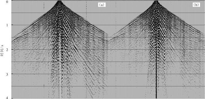
针对辽西金羊盆地火成岩覆盖区深层以往采集的地震数据反射能量弱、信噪比低的特点,计划利用地震低频信号来削弱火成岩地层对地震波场的屏蔽作用及髫髻山组底部砾岩层对地震波场的散射作用,从而提高深层反射信号能量和信噪比、改善其下伏地层成像质量。为此,2018年针对自然频率为5Hz的低频检波器与常规10Hz检波器进行试验对比研究,在13线同时铺设2条接收排列,分别采用2只SN5-5低频检波器串联与10只SN7C-10检波器面积组合接收对比。图 2为不同检波器接收单炮地震记录对比,可见采用SN5-5低频检波器2只串联接收的单炮地震记录在髫髻山组火成岩下伏地层(1 s以下)的地震反射能量相对于常规SN7C-10检波器10只面积组合接收的能量更强、有效地震反射同相轴连续性更好。同时采用SN5-5低频检波器接收的单炮地震记录在髫髻山组火成岩下伏地层的地震反射有效频带更宽、低频信息更丰富(图 3)。
在充分的检波器试验对比基础上,优选SN5-5低频检波器2只串联接收,同时采用高密度炸药震源进行大能量井炮激发,于髫髻山组火成岩下伏地层取得了能量较强、信噪比高的反射地震资料。通过实践进一步证明了2只SN5-5低频检波器串联接收的单炮记录低频信息更丰富、深层反射信号能量更强,有效地削弱了髫髻山组火成岩地层对地震波场的屏蔽作用及髫髻山组底部砾岩层对地震波场的散射影响,采集到了火成岩下伏地层高品质的地震数据,为低频检波器在火成岩等高速层屏蔽地区的推广应用奠定了基础。
3.2 深层信号能量恢复技术
地震波在传播过程中会受到地层对其的吸收衰减等因素影响,其能量往往在浅层强、深层弱,而且分布不均。同时,由于地表条件的差异,横向上各炮、道间能量差异较大,不同测线单炮记录之间的能量差别更大。为了消除地层吸收与激发、接收等因素造成的空间能量不均衡问题,必须对地震波的能量进行有效补偿。目前业界在地震数据处理时一方面通过球面扩散补偿对由于球面扩散、地层吸收造成的地震记录道的能量随时间的衰减进行校正,以均衡浅、中、深层地震能量;另一方面采用地表一致性振幅补偿技术对地震波在传播过程中由于激发因素和接收条件的不一致性引起的振幅能量衰减进行补偿处理(卢占武等,2009;汪功怀等,2011)。
然而,当地震波在地下传播过程中遇到两种不同弹性介质分界面时不但会发生反射,同时也会产生地震波的透射现象,其能量损失有一部分是由透射损失造成的。实际资料中由透射造成的有效反射波的能量损失无法通过球面扩散和吸收衰减的补偿来弥补(许艳萍等,2007),因此透射损失补偿对于高保真振幅处理是不可忽视的。尤其对于像辽西金羊盆地这类浅层大面积火成岩分布的地区,其波阻抗与围岩差异大、对有效波具有较强的屏蔽作用,从而造成深层有效反射波能量较弱,如能对其进行透射补偿来恢复目的层反射波的真实振幅则更有利于后续的构造与储层解释。
对于透射损失的计算既可以利用几何理论方法,也可以应用波动理论方法。几何理论认为整个地下层系的透射损失是由地震波向下和向上传播过程经过的每个界面的透射系数累乘后得到的。按照几何透射理论,随着反射界面的急剧增加,其透射系数将迅速减小,当地震波在地下实际细密分层介质中传播时在地表难以接收到深部的反射波(许艳萍等,2007)。而波动理论认为当地震波向下传播时,除存在如几何理论那样的一次透射波外,还存在大量的向下传播的层间多次波,它们将叠加在一次透射波上,增强了向下或向上的透射波振幅或能量。从波动方程导出的透射系数公式,它不仅包括波通过每个界面时产生的透射损失,而且还包括层间多次波的效应。为此在进行透射损失补偿处理中需要用不包含透射损失因素、仅有一次反射波的时间域褶积合成道作为实际地震道经透射补偿后的标准。图 4和图 5分别为采用球面扩散补偿、地表一致性振幅补偿和透射损失补偿技术串联的流程进行振幅补偿前后的单炮地震记录和叠加剖面对比,可见补偿后的单炮地震记录和叠加剖面在纵向和横向能量基本达到均衡,深层有效信息得以充分显现,剖面整体能量在纵向时间方向和横向空间方向均趋于一致,火成岩层以下的深部地层反射能量得到了有效提升,消除了由于激发、接收因素和透射损失造成的地震反射波能量在纵横向的差异。
3.3 多域分级综合去噪技术
噪声是影响地震资料精度的重要因素,因此有效压制地震记录中的各种干扰、最大程度地保留有效信号、提高地震资料的信噪比是地震数据处理的主要任务之一。基于辽西金羊盆地火成岩覆盖区的地震原始资料特征分析可知工区的面波和线性干扰尤为发育,同时存在异常振幅和单频信号等干扰。针对这些干扰噪音在时间域、频率域的特点及其与有效信号的差异,从噪音形成的机理上设计针对性的压噪方法对各类噪音进行去除。为此,采取多域分级综合去噪技术对上述各类干扰进行逐级压制、去除,以提高资料信噪比和成像剖面质量。
面波往往能量强、频率低,具有一定的分布空间和视速度范围的特点。根据面波和反射波在频率分布特征、空间分布范围以及能量等方面的差异,首先检测出面波在时间和空间上的分布范围;再根据面波与反射波传播路经不同导致它们的时距曲线形态也不同这一固有特征对面波进行二次分析,以确定面波的频率分布特征。并根据这些特征进行分离压制,从而实现衰减面波分量、保护有效信号的低频成分的目的。
线性干扰是辽西金羊盆地地震资料存在的另一种比较严重的噪声,其特点是具有一定的主频和视速度。因此,处理中根据线性干扰与有效波之间在视速度、位置和能量上的差别,在F-K域采用倾斜叠加和向前、向后线性预测的方法确定线性干扰的视速度、分布范围及规律,在此基础上将识别出的线性干扰从原始资料中剔除。该方法能够较好地保持振幅的相对关系,避免了二维滤波技术常常造成明显的信号畸变、伤害有效成分的弊端。
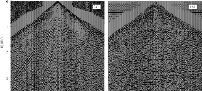
针对野外记录的单频信号、异常振幅、强能量等干扰,根据其与有效信号在不同域的特征差异进行了有效压制,以免其造成剖面振幅不均匀、后续成像处理中出现偏移画弧等现象影响资料品质。图 6和图 7分别为多域分级去噪前后单炮记录及水平叠加剖面的对比,明显看出去噪后炮点记录及水平叠加剖面的面波、线性干扰、单频信号、异常振幅等被有效压制,剖面信噪比得到较大幅度的提高。
3.4 高精度静校正技术
本区为山地地表,高程变化剧烈,落差达400 m以上,并且本区表层结构、低降速带厚度及速度变化大,带来较严重的静校正问题,为此开展了折射静校正和层析静校正等方法的对比试验,以便优选静校正方法来消除静校正问题对地震资料品质的影响。
折射波静校正法要求满足折射波法的地表一致性假定条件,即在激发点和接收点地震波均是沿垂直方向传播,这表示任何一个地震道的静校正量只与激发点和接收点的地表位置有关,而与地震道的炮检距及地震波的入(出)射等因素无关(王淑玲,2012)。当近地表存在较稳定的折射层时其静校正效果往往比较好,但对于辽西金羊盆地等山地起伏地表且表层结构复杂的地区很难找到稳定的折射层,难以满足折射波法的地表一致性假定条件,因此导致折射静校正方法在复杂地表区的实用性较差。
层析静校正法相对于折射静校正法的优势在于该技术不需对地表高差、低速带速度结构做任何假设条件(许艳萍等,2007),适合用于近地表低降速带速度并非严格成层、纵横向变化剧烈的实际情况,是复杂地表区有效的静校正方法。层析静校正法采用高密度的小网格进行速度划分,可以描述十分复杂的速度场。该技术利用初至波的传播走时和路径反演表层的速度结构,并计算静校正量。主要包括三个步骤:①建立工区近地表速度模型;②通过正演计算每个炮检对的旅行时间;③通过对比反演的初至时间与拾取的初至时间计算近地表速度模型的修正量,通过迭代更新速度模型,最终获得精确的地表速度模型(宋佳等,2016)。
速度与静校正问题相辅相成,精确的速度结构有利于静校正问题的解决,同时静校正问题的解决有利于获得高精度的速度模型。在地表条件复杂、低速带厚度和速度变化大的区域,经过一次静校正后仍不能保证动校正后的共中心点(CMP)道集反射波能够同相叠加。为此通过高密度速度分析、动校正等手段在CMP道集上做剩余静校正,使同一个CMP道集内各道反射波到达时间相同,以解决短波长、小静校正量问题,提高成像精度、准确性和资料的信噪比。
处理中通过优化速度谱参数来提高速度谱质量,并采用多次高密度速度分析、剩余静校正迭代优化来进一步消除剩余静校时差,直到迭代次数满足校正量小于1个样点间隔,从而确保同相叠加。具体方法是在对整条线进行速度扫描,掌握每套层位的速度范围和构造情况的基础上,利用速度谱结合速度扫描进行高密度精细速度分析,求取对应点的速度值;接下来针对速度剖面中的异常点返回到速度扫描,再结合叠加剖面分析异常点的合理性,并调整速度谱;最后,利用剩余静校正和高密度速度分析的多次迭代来优化速度分析的精度,并解决剩余时差问题。图 8为静校正前后单炮记录对比,图 9为不同方法静校正的叠加剖面对比,可以明显看出通过静校正、剩余静校正与高密度速度分析的多次迭代,地震反射同相轴连续性得到明显提升,静校正问题得以解决。
3.5 高精度速度建模与叠前时间偏移成像处理技术
叠前时间偏移是解决复杂构造成像问题的有效方法,克希霍夫积分法偏移能够基于地震记录选择激发点源和相应地震波射线束的密度对某一预定目标进行偏移成像,其精度可达到不受远场近似及地层倾角限制的程度。叠前时间偏移将共中心点(CMP)道集转换成共反射点(CRP)道集,考虑了复杂陡倾界面的CMP道集反射点离散问题,射线可以弯曲,能部分适应速度在纵向和横向的变化。偏移孔径、最大成像倾角和偏移速度是叠前时间偏移的最重要的几个参数,对最终成像效果至关重要。
偏移孔径是指偏移成像时每个面元所包含的数据范围,对积分法叠前时间偏移而言,孔径太小则无法使陡倾的反射界面归位准确,绕射无法彻底收敛,造成振幅变化剧烈,并且使随机噪音转化为以假水平同相轴为主的干扰,这种现象通常在剖面的深部尤为严重;孔径太大则意味着计算量的增加,信噪比降低,特别是当深层存在异常干扰时,大孔径则会使深部的噪音对中深层地震资料成像质量产生严重影响。为了使得深浅地层都能得到有效归位,处理中遵循平层孔径小、斜层孔径大,浅层孔径小、深层孔径大的原则对任一指定的时间,确定初始孔径参数为输入剖面中最陡的有效同相轴在偏移中最大水平位移的两倍,即:

(1) 其中,dx为偏移前后的水平位移;v为区域平均速度;θt为时间t处偏移前时间剖面上反射同相轴的倾角,且tan(θt)=Δt/Δx。
最大成像倾角的确定既要能保证工区内最大陡倾角断面波和地层反射波偏移成像,又要保证不能因倾角太大使深部的噪音影响到较好的中浅层资料,降低中浅层资料信噪比。为了确定合适的最大成像倾角在处理过程中需要选择测试线进行偏移试验,通过对比偏移后剖面中深层大倾角地层、断面波等陡构造成像效果确定倾角大小。
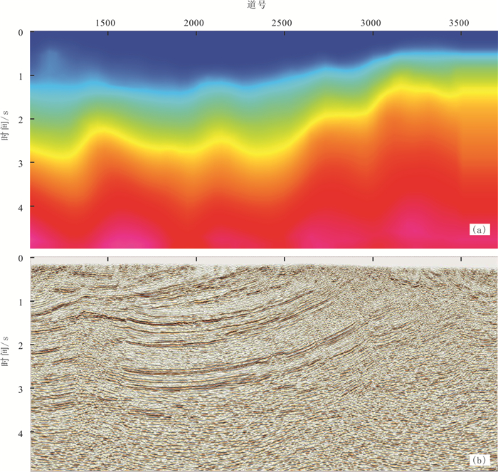
构造倾斜和速度的横向变化会引起CMP道集的共中心点发散,造成求取速度困难,叠前时间偏移对速度的敏感度要比叠后偏移大得多。而且叠前时间偏移可以消除构造倾角和其它横向速度变化的影响,得到的CRP道集反映同一反射点的信息,同时包含的信息也更丰富,速度规律更明显,因此可以借助叠前时间偏移的迭代处理,利用叠前CRP成像道集的同相轴是否拉平来判断速度模型的正确性,从而更准确地求取偏移速度。其具体方法是首先利用常规DMO速度谱数据建立初始速度模型,进行弯曲射线Kirchhoff叠前时间偏移,得到时间域共反射点道集后反动校;然后基于该道集所作的速度谱及道集动校正交互拾取高密度速度谱,重新建立速度模型;再进行各向异性弯曲射线Kirchhoff叠前时间偏移,对时间域共反射点道集再做反动校,又得到反动校后的共反射点道集,并再次拾取高密度速度谱;如此迭代修正速度谱数据对来达到不断优化速度模型的目的。速度谱数据对于拾取正确与否是通过CRP道集的有效反射波同相轴是否拉平来验证,如同相轴向上翘,则速度偏小,如同相轴向下弯,则速度偏大。若同相轴未拉平,应通过多次剩余速度分析对模型作进一步的修改,如此迭代来更好地优化叠前时间偏移速度模型,直到达到满意的叠前时间偏移效果。图 10为09线叠前时间偏移最终速度场及偏移剖面,明显看出速度场结构与构造趋势相关性高,地层成像清晰、凹陷两侧的断层与倾斜地层成像清晰,可以为后续的构造解释提供高质量的地震资料。
4. 应用效果分析
针对辽西金羊盆地深、浅层复杂的地震地质条件、火成岩覆盖区地震数据特点和资料处理中面临的静校正、噪音干扰、深层能量弱、成像效果不佳等技术难点,资料处理过程中通过处理流程和参数测试设计了针对性的技术方案。针对表层结构、低降速带及地表高程变化大带来的较严重静校正问题,通过多种静校正方法对比分析,优选层析静校正方法消除了高程和低降速带变化对资料造成的影响;针对多类噪音干扰,利用其与有效信号在时间域、频率域的不同特征采用多域联合压噪的技术对干扰噪音进行了有效衰减;联合应用球面扩散补偿、地表一致性振幅补偿和透射损失补偿技术消除了地震剖面能量在纵向和横向上的差异,对由于透射损失导致的火成岩层以下深部反射能量减弱的现象进行了补偿、使得深层能量得以有效提升。在高精度静校正、多域联合去噪和能量补偿的基础上,通过叠前时间偏移、反动校和速度谱拾取的迭代优化处理实现了不同偏移距地震道的同向叠加、建立了高精度的速度场,应用叠前时间偏移技术进行了最终成像处理。
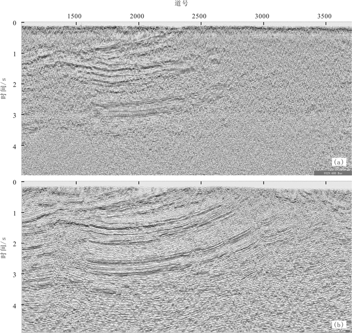
图 11是09测线叠前时间偏移成果剖面与以往叠后时间偏移处理成果对比,可以看到重新处理的叠前时间偏移剖面信噪比更高、深层反射波能量得以有效提升、地层成像清晰,尤其在倾斜地层和断层等方面成像效果较以往的处理成果得以明显改善,地层反射同相轴连续性明显增强,浅、中、深层地震反射清晰。被髫髻山组火成岩覆盖的主要目的层北票组沉积层与中上元古界地层的地震反射同相轴连续性好,构造形态清楚,分辨率较高,断裂特征清楚,地层接触关系明显。有利于金羊盆地的构造解释及有利圈闭的落实,为下一步井位部署提供了高质量的地震成像资料。
5. 结论
火成岩等高速层覆盖区域常规纵波地震勘探面临的技术问题主要包括地震信号被严重屏蔽、全反射临界角小、透射能量弱、深层反射能量弱,并且被多次波等干扰、有效成像困难。在采集方面宜采用火成岩顶面大能量激发,小道间距、低频检波器接收,宽线、高覆盖次数的观测系统进行地震数据采集。
针对火成岩覆盖区地震原始资料特点和地震地质条件,在辽西金羊盆地二维地震数据重新处理中在多角度能量补偿、高精度静校正、多域联合压噪的基础上进行高密度速度分析与剩余静校正迭代来优化偏移速度场,最终应用各向异性叠前时间偏移技术使得髫髻山组火成岩下伏地层反射波能量得以恢复、地层成像清晰、反射同相轴连续性明显增强,尤其对于倾斜地层和断层等方面的成像效果得以明显改善。
辽西金羊盆地表层地震地质条件差、浅层火成岩覆盖、深层构造复杂,经过理论分析、参数和流程试验,优选出针对性的采集、处理措施,最终地震成像剖面地层反射连续、构造特征清楚、盆地及凹陷结构清晰;在火成岩等高速层覆盖区域后续可探索应用转换波、广角地震勘探等技术,以进一步提高火成岩等高速屏蔽层之下地层的地震波能量和成像效果。
-
-
Chen Shuwang, Xu Guang, Yang Jianguo, Li Yongfei, Zhang Jian, Zhao Hongwei, Gong Fanhao, Sun Shouliang, Li Shichao, Su Fei, Zhang Wenhao, Wang Dandan, Zhang Jiaodong. 2021. Foundational, geological, survey for oil and gas resources in songliao basin and its periphery areas: Progress and prospect[J]. Geology and Resources, 30(3): 221-231, 248(in Chinese with English abstract).
Gao B, Zhao B Y, Shi W W, Xing W J, Yang X L. 2014. The application and effect of RTM technology on igneous rocks fine imaging in NP1 Area[C]//SEG Global. Meeting Abstracts: 906-909.
Gao B, Zhao B Y, Zhang M, Xu W H, Zhang J K. 2016. The seismic prediction technologies of sandstone reservoir in igneous rock development areas in NP1 Structural Belt[C]//SEG Global. Meeting Abstracts: 392-395.
Guo Shuxiang. 2008. Using low-frequency information to improve the qual. ity of seismic imaging[J]. Petroleum Geophysics, 6(4): 5-8(in Chinese with English abstract). http://en.cnki.com.cn/Article_en/CJFDTOTAL-YQDL200804004.htm
Hao H M, Zhang J, Dong L, Ma Q L, Jin Z G. 2011. Seismic exploration practice in igneous rock region of Fushan sag[C]//SEG Global. Meeting Abstracts: 53-53.
He Bao, Fu Qiuping, Zhang Yaming. 2006. Beipiao group hydrocarbon material. distribution and organic matter abundance of Jinlingsi-Yangshan basin in western part of Liaoning[J]. Journal of Liaoning Technical University (Natural Science Edition), 25(1): 24-27(in Chinese with English abstract). http://www.researchgate.net/publication/294704166_Beipiao_group_hydrocarbon_material_distribution_and_organic_matter_abundance_of_Jinlingsi-Yangshan_basin_in_western_part_of_Liaoning
He Bao, Li Maofeng, Liu Yingxin. 2008. Jinlingsi-Yangshan basin Beipiao Formation hydrocarbon source rock characteristics[J]. Coal Geology of China, 20(3): 25-27, 55(in Chinese with English abstract). http://en.cnki.com.cn/Article_en/CJFDTOTAL-ZGMT200803007.htm
Hu Zhongping, Guan Luping, Gu Lianxing, Wang Liangshu, Wu Dali, Dong Yourui, Zhao Qun. 2004. Wide angle seismic wave field analysis and imaging method below the high velocity shield layers[J]. Chinese Journal of Geophysics, 47(1): 88-94(in Chinese with English abstract). http://www.onacademic.com/detail/journal_1000039123558110_c9e3.html
Jiang Z R, Sun Y F, Liu S G, Lin K. 2019. Quantitative identification of pseudofaults underlying igneous rocks through wave-equation-based velocity modeling: A case study of the Shuntuoguole uplift, Tarim Basin, China[J]. Interpretation, 7: T499-T512. doi: 10.1190/INT-2018-0107.1
Li Keen, Xiong Xiaojun, Yang Jun. 2006. Seismic acquisition anal. ysis in the area of high velocity shielding layers[J]. Natural Gas Geoscience, 17(4): 527-531(in Chinese with English abstract). http://www.oalib.com/paper/1417789
Li Na. 2016. The application of tomographic static correction for three-dimensional. seismic data processing in FZ region[J]. Computing Techniques For Geophysical and Geochemical. Exploration, 38(4): 525-529(in Chinese with English abstract). http://www.researchgate.net/publication/316951594_The_application_of_tomographic_static_correction_for_three-dimensional_seismic_data_processing_in_FZ_region
Li Yong, Song Zongping, Li Qiong, Li Zhengwen. 2008. Research on the identification technique and application of seismic characteristics for volcanic rocks[J]. Journal of Mineralogy and Petrology, 28(3): 105-110(in Chinese with English abstract). http://www.researchgate.net/publication/298184694_Research_on_the_identification_technique_and_application_of_seismic_characteristics_for_volcanic_rocks
Li Yongfei, Chen Shuwang. 2014. New findings on oil and gas resources investigation in Jinlingsi-Yangshan Basin, western Liaoning[J]. Geologcal Bulletin of China, (9): 1463-1464(in Chinese with English abstract). http://d.wanfangdata.com.cn/Periodical/zgqydz201409023
Li Yongfei, Yan Qingchang, Liu Bing, Sun Shouliang, Liu Xuezhen. 2018. Results Figures of 2D Seismic in the Northern and Adjacent Areas of the Jinyang Basin, Western Liaoning[M]. Beijing: Geological Publishing House, 1-149.
Liu Maozheng, He Huangsheng, Sun Chao. 2015. Analysis of application effect of wide-angle reflection in shale gas seismic exploration[J]. Energy Technology and Management, 40(4): 172-174(in Chinese).
Lu Zhanwu, Gao Rui, Li Qiusheng, Kuang Zhaoyang, Liu Jinkai, Li Pengwu, Guanye, He Rizheng, Wang Haiyan. 2009. A study of seismic reflection profiles and stack velocities in Qiangtang basin, northern Tibet[J]. Geology in China, 36(3): 677-681(in Chinese with English abstract). http://en.cnki.com.cn/Article_en/CJFDTOTAL-DIZI200903016.htm
Pei Zhenglin, Mu Yongguang. 2004. Study of seismic wave propagation regularity in igneous rock area[J]. Geophysical. Prospecting For Petroleum, 43(5): 433-437(in Chinese with English abstract). http://d.wanfangdata.com.cn/periodical/sywt200405004
Penna R, Araújo S, Geisslinger A, Sansonowski R, Oliveira L, Rosseto J, Matos M. 2019. Carbonate and igneous rock characterization through reprocessing, FWI imaging, and elastic inversion of a legacy seismic data set in Brazilian presalt province[J]. The Leading Edge, 38: 11-19. doi: 10.1190/tle38010011.1
Penna R, Araújo S, Sansonowski R, Oliveira L, Rosseto J, Geisslinger A, Matos M. 2018. Igneous rock characterization through reprocessing, FWI imaging, and elastic inversion of a legacy seismic dataset in Brazilian Pre-Salt Province[C]//SEG Technical. Program Expanded Abstracts: 3277-3281.
She Deping, Wu Jimin, Li Pei, Jin Xiaolei. 2006. Application of low-frequency signal. s to imaging of deep layers in subbasalt areas[J]. Journal of Hohai University (Natural Sciences), 34(1): 83-87(in Chinese with English abstract). http://en.cnki.com.cn/Article_en/CJFDTOTAL-HHDX200601019.htm
She Deping, Guan Luping, Xu Ying, Li Pei. 2007. Applying of low-frequency signal. to improve imaging quality below shielding high-velocity basalt[J]. Oil Geophysical Prospecting, 42(5): 564-567(in Chinese with English abstract). http://www.researchgate.net/publication/293234408_Applying_of_low-frequency_signal_to_improve_imaging_quality_below_shielding_high-velocity_basalt
Song Jia, Wang Guoju. 2016. Study on refraction static correction and tomostatics in complicated mountain area[J]. Coal and Chemical. Industry, 39(8): 50-52(in Chinese with English abstract). http://en.cnki.com.cn/Article_en/CJFDTOTAL-HHGZ201608016.htm
Sun Dong, Shi Xiaoqian, Wang Zhengqing, Chen Lixin, Wang Jing, Sun Jiaqing, Dai Dongdong, Fang Qifei. 2018. The influence of Permian igneous rock on the seismic imaging of underlying strata in Hanilcatam area, Tarim Basin[J]. Natural Gas Geoscience, (12): 1781-1787(in Chinese with English abstract). http://www.researchgate.net/publication/332250672_The_influence_of_Permian_igneous_rock_on_the_seismic_imaging_of_underlying_strata_in_Hanilcatam_area_Tarim_Basin
Sun Peng, Tang Youjun, Zhang Kun. 2020. A new type of oil sands in the Beipiao Formation of Jinyang Basin, Western Liaoning Province: geochemical characteristics and geological implication[J]. Geology and Resources, 29(4): 335-341(in Chinese with English abstract).
Sun Qiushi, Zhang Kun, Li Yongfei, Gao Xiaoyong, Sun Shouliang, Zhang Tao, Zong Wenming, Sun Peng, Zhang Zhe. 2018. Characteristics and implication of biomarker compounds in source rocks from Beipiao Formation in Jinyang basin, western Liaoning Province[J]. Geology and Resources, 27(1): 69-76(in Chinese with English abstract). http://en.cnki.com.cn/Article_en/CJFDTOTAL-GJSD201801009.htm
Sun Shouliang, Li Yongfei, Gao Xiaoyong, Zhou Tiesuo, Zhang Tao, Wang Senhou. 2017. An analysis of the genesis and geochemical characteristics of shale gas in Lower Jurassic Beipiao Formation in Jinyang Basin[J]. Geologcal Bulletin of China, 36(4): 575-581(in Chinese with English abstract). http://www.researchgate.net/publication/318262662_An_analysis_of_the_genesis_and_geochemical_characteristics_of_shale_gas_in_Lower_Jurassic_Beipiao_Formation_in_Jinyang_Basin
Sun Shouliang, Li Yongfei, Chen Shuwang, Gao Xiaoyong, Sun Qiushi, Zhang Kun, Zhou Tiesuo. 2017. Depositional. environment and organic geochemical. characteristics of source rocks of Beipiao Formation in Jinyang Basin[J]. World Geology, 36(3): 889-902(in Chinese with English abstract). http://www.en.cnki.com.cn/Article_en/ http://search.cnki.net/down/default.aspx?filename=SJDZ201703023&dbcode=CJFD&year=2017&dflag=pdfdown
Wang Gonghuai, Zhao Tiefeng, Zhang Zhongling. 2011. The method for low signal noise ratio seismic data processing in Bachu uplift, Tarim Basin[J]. Geology in China, 38(4): 1048-1060(in Chinese with English abstract). http://en.cnki.com.cn/Article_en/CJFDTOTAL-DIZI201104023.htm
Wang Jianhua, Li Qingzhong, Qiu Rui. 2003. Energy shielding action of shallow strong reflector[J]. Oil Geophysical Prospecting, 38(6): 589-596(in Chinese with English abstract).
Wang Shuling. 2012. Application analysis of constrained tomographic static correction technique[J]. Geophysical Prospecting for Petroleum, 51(4): 383-387(in Chinese with English abstract). http://en.cnki.com.cn/Article_en/CJFDTOTAL-SYWT201204014.htm
Wang Shuling. 2014. Improving the igneous rocks imaging of the lower formations with forward simulation technologies——a case study on lower igneous rocks in yangxin sag[J]. Journal of Mineralogy and Petrology, 34(3): 98-103(in Chinese with English abstract). http://en.cnki.com.cn/Article_en/CJFDTOTAL-KWYS201403013.htm
Wang X Y, Zhao X, Zhang M, Zhang L, Liu W. 2016. Application and effects of high density swath 3D technique in igneous rock area[C]//SEG Global. Meeting Abstracts: 235-238.
Wang Yang, Wang Zaijun, Zhu Yanping. 2020. Appliction of gravity-seismic inversion in petroleum resources evaluation of the Labudalin basin[J]. Geology and Resources, 29(2): 135-141(in Chinese with English abstract).
Wang Zhi, He Zhenhua, Huang Deji, Wang Ximing, Du Zhengcong. 2002. A seismic survey method for weak reflectors below shielded layer of high velocity: Wide angle reflection[J]. Progress in Exploration Geophysics, 25(5): 23-27. http://en.cnki.com.cn/Article_en/CJFDTOTAL-KTDQ200205003.htm
Wu Zhiqiang, Luo Di, Zeng Tianjiu, Xiao Guolin, Zeng Youai, Sun Yunbao. 2014. Technical Difficulties and Countermeasures of Petroleum Seismic Exploration in the South Yellow Sea Basin[J]. Marine Origin Petroleum Geology, 73(3): 8-17(in Chinese with English abstract). http://en.cnki.com.cn/Article_en/CJFDTotal-HXYQ201403003.htm
Xu Changbin. 2018. Preliminary exploration of oil and gas exploration potential in the Jurassic in the periphery of Liaohe River[J]. Petrochemical Industry Technology, 25(1): 163(in Chinese with English abstract). http://en.cnki.com.cn/Article_en/CJFDTotal-SHJS201801128.htm
Xu Mingcai, Liu Jianxun, Zhang Baowei, Wang Guangke. 2012. Experimental study on seismic prospecting technology under volcanic rock cover[J]. Geophysical and Geochemical Exploration, 36(6): 928-933(in Chinese with English abstract). http://en.cnki.com.cn/Article_en/CJFDTOTAL-WTYH201206009.htm
Xu Yanping, Xiao Liyun, Sun Changzan, Jiang Fangfen, Liu Zhongyan. 2007. Seismic data processing technology and application of near-surface igneous rock cover in Dayangshu Basin[J]. Natural Gas Industry, S1: 147-149(in Chinese).
Zhao Jixiang, Xu Yongzhong, Yang Zhilin, Wang Shuangshuang, Wu Gang. 2011. Forward modeling of single-shot recoding of high-velocity igneous rock based on Seismic Unix[J]. Energy Technology and Management, 2: 141-142(in Chinese).
Zhang Tao, Li Yongfei, Sun Shouliang, Gao Xiaoyong, Zhou Tiesuo, Sun Peng. 2017. Saturated hydrocarbon geochemical characteristics of the oil sand from YD1 well in Jinyang Basin and its significance for oil and gas exploration[J]. Geological. Bulletin of China, 36(4): 582-590(in Chinese with English abstract). http://en.cnki.com.cn/Article_en/CJFDTOTAL-ZQYD201704012.htm
Zhang T, Wang X, Liu W Q. 2019. The velocity modeling techniques of igneous rock-A case study of Ha-La-Ha-Tang area[C]//SEG Global Meeting Abstracts: 68-71.
Zhang Yabin, Yao Gang, Yang Ming. 2013. Seismic exploration technology used in igneous rock developed areas——By taking a certain sag of East China Sea Basin for Example[J]. Journal of Oil and Gas Technology, 35(1): 82-85(in Chinese with English abstract). http://en.cnki.com.cn/Article_en/CJFDTOTAL-JHSX201301019.htm
Zhen Zhen, Li Yongfei, Gao Xiaoyong, Sun Shouliang, Zhou Tie-Suo. 2016. Characteristics of sedimentary facies and organic matter of Lower Jurassic Beipiao Formation of Well SZK01 in Jinyang Basin[J]. Global Geology, 35(1): 207-215(in Chinese with English abstract). http://www.en.cnki.com.cn/Article_en/ http://search.cnki.net/down/default.aspx?filename=SJDZ201601021&dbcode=CJFD&year=2016&dflag=pdfdown
Zong Wenming, Sun Qiushi, Li Xiaohai, Gao Xiaoyong, Li Yongfei, Shi Lei, Xiong Quan. 2021. Hydrocarbon generation potential of beipiao formation from lld1 well in niuyingzi basin, western Liaoning[J]. Geology and Resources, 30(3): 350-356(in Chinese with English abstract).
陈树旺, 许光, 杨建国, 李永飞, 张健, 赵洪伟, 公繁浩, 孙守亮, 李士超, 苏飞, 张文浩, 王丹丹, 张交东. 2021. 松辽盆地及外围油气资源基础地质调查——"十三五"阶段进展与未来工作展望[J]. 地质与资源, 30(3): 221-231, 248. https://www.cnki.com.cn/Article/CJFDTOTAL-GJSD202103003.htm 郭树祥. 2008. 用低频信息改善地震成像质量[J]. 油气地球物理, 6(4): 5-8. https://www.cnki.com.cn/Article/CJFDTOTAL-DKYT200901014.htm 何保, 付秋萍, 张亚明. 2006. 辽西金羊盆地北票组烃源岩分布及有机质丰度[J]. 辽宁工程技术大学学报, 25(1): 24-27. https://www.cnki.com.cn/Article/CJFDTOTAL-FXKY200601007.htm 何保, 李茂丰, 刘颖鑫. 2008. 金岭寺-羊山盆地北票组烃源岩特征[J]. 中国煤炭地质, 20(3): 25-27, 55. doi: 10.3969/j.issn.1674-1803.2008.03.005 胡中平, 管路平, 顾连兴, 王良书, 邬达理, 董幼瑞, 赵群. 2004. 高速屏蔽层下广角地震波场分析及成像方法[J]. 地球物理学报, 47(1): 88-94. doi: 10.3321/j.issn:0001-5733.2004.01.013 李可恩, 熊晓军, 杨俊. 2006. 高速屏蔽层下地震数据的采集[J]. 天然气地球科学, 17(4): 527-531. doi: 10.3969/j.issn.1672-1926.2006.04.021 李娜. 2016. 层析静校正在FZ地区三维地震资料处理中的应用[J]. 物探化探计算技术, 38(4): 525-529. doi: 10.3969/j.issn.1001-1749.2016.04.14 李勇, 宋宗平, 李琼, 李正文. 2008. 火成岩体地震特征识别技术与应用研究[J]. 矿物岩石, 28(3): 105-110. doi: 10.3969/j.issn.1001-6872.2008.03.017 李永飞, 陈树旺. 2014. 辽西地区金岭寺-羊山盆地油气资源调查新发现[J]. 地质通报, (9): 1463-1464. doi: 10.3969/j.issn.1671-2552.2014.09.023 李永飞, 冉清昌, 刘兵, 孙守亮, 刘学珍. 2018. 辽西金羊盆地北部及邻区二维地震成果图集[M]. 北京: 地质出版社, 1-149. 刘茂争, 何黄生, 孙超. 2015. 页岩气地震勘探中广角反射应用效果分析[J]. 能源技术与管理, 40(4): 172-174. doi: 10.3969/j.issn.1672-9943.2015.04.067 卢占武, 高锐, 李秋生, 匡朝阳, 刘金凯, 李朋武, 管烨, 贺日政, 王海燕. 2009. 藏北羌塘盆地反射地震剖面与叠加速度研究[J]. 中国地质, 36(3): 677-681. doi: 10.3969/j.issn.1000-3657.2009.03.014 裴正林, 牟永光. 2004. 火成岩区地震波传播规律研究[J]. 石油物探, 43(5): 433-437. doi: 10.3969/j.issn.1000-1441.2004.05.004 佘德平, 吴继敏, 李佩, 金晓蕾. 2006. 低频信号在玄武岩地区深层成像中的应用研究[J]. 河海大学学报(自然科学版), 34(1): 83-87. https://www.cnki.com.cn/Article/CJFDTOTAL-HHDX200601019.htm 佘德平, 管路平, 徐颖, 李佩. 2007. 应用低频信号提高高速玄武岩屏蔽层下的成像质量[J]. 石油地球物理勘探, 42(5): 564-567. doi: 10.3321/j.issn:1000-7210.2007.05.014 宋佳, 王国举. 2016. 折射波静校正与层析静校正在复杂山区适用性研究[J]. 煤炭与化工, 39(8): 50-52. https://www.cnki.com.cn/Article/CJFDTOTAL-HHGZ201608016.htm 孙东, 石小茜, 王振卿, 陈利新, 王靖, 孙甲庆, 代冬冬, 房启飞. 2018. 塔里木盆地哈拉哈塘地区二叠系火成岩体对下伏地层地震成像影响[J]. 天然气地球科学, (12): 1781-1787. doi: 10.11764/j.issn.1672-1926.2018.10.019 孙鹏, 唐友军, 张坤. 2020. 辽西金羊盆地北票组一类新的油砂地球化学特征及意义[J]. 地质与资源, 29(4): 335-341. https://www.cnki.com.cn/Article/CJFDTOTAL-GJSD202004005.htm 孙求实, 张坤, 李永飞, 郜晓勇, 孙守亮, 张涛, 宗文明, 孙鹏, 张哲. 2018. 辽西金羊盆地北票组烃源岩生物标志化合物特征及意义[J]. 地质与资源, 27(1): 69-76. https://www.cnki.com.cn/Article/CJFDTOTAL-GJSD201801009.htm 孙守亮, 李永飞, 郜晓勇, 周铁锁, 张涛, 王森厚. 2017. 辽西金羊盆地下侏罗统北票组页岩气地球化学特征及其成因[J]. 地质通报, 36(4): 575-581. https://www.cnki.com.cn/Article/CJFDTOTAL-ZQYD201704011.htm 孙守亮, 李永飞, 陈树旺, 郜晓勇, 孙求实, 张坤, 周铁锁. 2017. 金羊盆地北票组沉积环境及烃源岩有机地球化学特征[J]. 世界地质, 36(3): 889-902. https://www.cnki.com.cn/Article/CJFDTOTAL-SJDZ201703023.htm 汪功怀, 赵铁枫, 张中灵. 2011. 塔里木盆地巴楚隆起低信噪比地震资料处理方法研究[J]. 中国地质, 38(4): 1048-1060. http://geochina.cgs.gov.cn/geochina/ch/reader/view_abstract.aspx?file_no=20110421&flag=1 王建花, 李庆忠, 邱睿. 2003. 浅层强反射界面的能量屏蔽作用[J]. 石油地球物理勘探, 38(6): 589-596. https://www.cnki.com.cn/Article/CJFDTOTAL-SYDQ200306002.htm 王淑玲. 2012. 约束层析静校正方法应用效果分析[J]. 石油物探, 51(4): 383-387. https://www.cnki.com.cn/Article/CJFDTOTAL-SYWT201204014.htm 王淑玲. 2014. 利用正演模拟技术改善火成岩下目标层成像——以阳信洼陷火成岩下成像研究为例[J]. 矿物岩石, 34(3): 98-103. https://www.cnki.com.cn/Article/CJFDTOTAL-KWYS201403013.htm 汪洋, 汪在君, 朱彦平. 2020. 重力-地震联合反演解释技术在拉布达林盆地油气资源评价中的应用[J]. 地质与资源, 29(2): 135-141. https://www.cnki.com.cn/Article/CJFDTOTAL-GJSD202002004.htm 王志, 贺振华, 黄德济, 王熙明, 杜正聪. 2002. 高速屏蔽层下弱反射层地震勘探——广角反射[J]. 勘探地球物理进展, 25(5): 23-27. https://www.cnki.com.cn/Article/CJFDTOTAL-KTDQ200205003.htm 吴志强, 骆迪, 曾天玖, 肖国林, 曾友爱, 孙运宝. 2014. 南黄海海相油气地震勘探难点分析与对策建议[J]. 海相油气地质, 73(3): 8-17. https://www.cnki.com.cn/Article/CJFDTOTAL-HXYQ201403003.htm 许长斌. 2018. 辽河外围侏罗系油气勘探潜力初步探讨[J]. 石化技术, 25(1): 163. https://www.cnki.com.cn/Article/CJFDTOTAL-SHJS201801128.htm 徐明才, 刘建勋, 张保卫, 王广科. 2012. 火成岩盖层下地震找矿技术试验[J]. 物探与化探, 36(6): 928-933. http://www.cnki.com.cn/Article/CJFDTotal-WTYH201206009.htm 许艳萍, 肖立云, 孙长赞, 蒋芳芬, 刘忠岩. 2007. 大杨树盆地近地表火成岩覆盖区地震资料处理技术及应用[J]. 天然气工业, S1: 147-149. https://www.cnki.com.cn/Article/CJFDTOTAL-TRQG2007S1052.htm 赵吉祥, 许永忠, 杨芝林, 王双双, 武刚. 2011. 基于Seismic Unix的高速火成岩体单炮记录正演模拟[J]. 能源技术与管理, 2: 141-142. https://www.cnki.com.cn/Article/CJFDTOTAL-JSMT201102057.htm 张涛, 李永飞, 孙守亮, 郜晓勇, 周铁锁, 孙鹏. 2017. 辽宁金羊盆地羊D1井油砂地球化学特征及意义[J]. 地质通报, 36(4): 582-590. https://www.cnki.com.cn/Article/CJFDTOTAL-ZQYD201704012.htm 张亚斌, 姚刚, 杨明. 2013. 火成岩发育地区地震勘探方法研究——以东海盆地某凹陷为例[J]. 石油天然气学报, 35(1): 82-85. https://www.cnki.com.cn/Article/CJFDTOTAL-JHSX201301019.htm 甄甄, 李永飞, 郜晓勇, 孙守亮, 周铁锁. 2016. 金羊盆地SZK01井下侏罗统北票组沉积相及其有机质特征[J]. 世界地质, 35(1): 207-215. https://www.cnki.com.cn/Article/CJFDTOTAL-SJDZ201601021.htm 宗文明, 孙求实, 李晓海, 郜晓勇, 李永飞, 石蕾, 熊荃. 2021. 辽宁凌源牛营子盆地辽凌地1井北票组生烃潜力分析[J]. 地质与资源, 30(3): 350-356. https://www.cnki.com.cn/Article/CJFDTOTAL-GJSD202103017.htm -
期刊类型引用(3)
1. 赵超峰,田建涛,张伟,韩继伟,付昌,任丽莹,张晴,刘志伟. 辽河拗陷大民屯凹陷S281块高密度宽线二维地震采集实践. 地质与资源. 2024(02): 178-186 .  百度学术
百度学术
2. 王兴宇,王通,李广才,陈德元,刘艳丽. 火山岩覆盖区二维反射地震成像处理对策——以松辽外围西部盆地为例. 地质与资源. 2024(06): 759-769 .  百度学术
百度学术
3. 孙月成,周锡明,刘洋,陈树旺,张健,杨光,鹿琪,陈艺竹,张海华,苏飞,卞雄飞,公繁浩,张德军,孙雷,李晓海. 松辽盆地深部上古生界物性特征与典型区勘探实践. 吉林大学学报(地球科学版). 2022(06): 1747-1761 .  百度学术
百度学术
其他类型引用(0)


 下载:
下载:


