Lithofacies paleogeography during the depositional period of the Nanhua System Datangpo Formation and its indications for hydrocarbon accumulation in the Middle and Upper Yangtze Region, South China
-
摘要:研究目的
中上扬子地区在新元古代南华纪中期发育大塘坡组海相黑色含锰碳质页岩,长期以来作为锰矿层被广泛关注,但对其油气地质特征研究较少。本文从油气地质角度详细阐述了大塘坡组岩相古地理及其对油气成藏的指示作用,以期为中国南方地区油气调查提供指导。
研究方法通过野外地质调查和资料收集,采用单井分析、连井对比、岩相古地理图编制等方法,结合烃源岩特征分析、储层分析等实验测试手段,详细梳理了大塘坡组沉积特征和油气地质条件,分析了烃源岩特征和潜在油气组合。
研究结果大塘坡组形成于间冰期,沉积过程受拉张裂陷过程控制,可划分出2大类沉积相、7类沉积亚相及若干微相,整个沉积期构成一个完整的海侵—高位—海退沉积旋回;大塘坡组最具油气资源潜力的相带为局限陆棚亚相和潟湖亚相,主要分布在大塘坡组一段,有机地球化学指标特征好,为优质烃源岩。
结论大塘坡组一段具有良好的生烃潜力和页岩气发育潜力,松桃、花垣、秀山、湘潭、鹤峰等地区具有页岩气发育有利条件,为潜在页岩气发育区。以大塘坡组为烃源岩发育多种成藏组合,渝黔湘交界的秀山、松桃、花垣地区,源储配置条件较好,为潜在常规油气发育区。
创新点:阐述了南方地区油气调查潜在层系成藏机制:(1)系统收集南华系大塘坡组剖面和钻孔资料,从油气地质角度进行了梳理分析,确定了最具油气资源潜力的沉积相类型;(2)开展了大塘坡组生烃潜力、页岩气发育潜力和成藏条件分析,优选了油气、页岩气潜在发育区,指示了油气调查方向。
Abstract:This paper is the result of oil and gas exploration engineering.
ObjectiveThe marine black manganese−bearing carbonaceous shale of the Datangpo Formation, widely distributed in the mid−Neoproterozoic Nanhua strata of the Middle−Upper Yangtze Region, South China, has been extensively studied as a manganese deposit but remains poorly investigated regarding its petroleum geological characteristics. This study systematically analyzes the lithofacies paleogeography of the Datangpo Formation and evaluates its implications for hydrocaron accumulation, providing critical insights for guiding petroleum exploration in the southern China.
MethodsThrough field surveys and comprehensive data synthesis of the Datangpo Formation, we systematically evaluated hydrocarbon conditions, source rock geochemistry, and reservoir−caprock assemblage, especially lithofacies and paleogeography. This integrated approach combined individual well log interpretation, multi−well correlation analysis, and lithofacies paleogeographic with advanced analytical techniques including organic geochemical testing, petrophysical characterization, and reservoir diagenesis evaluation.
ResultsThe Datangpo Formation developed during an interglacial period, withits depositional architectureconstrained by extensional riftdynamics.Sedimentary facies within the formationare classified into two principaltypes, seven subcategories and multiple microfacies. The sequencecomprises a complete transgressive−highstand−regressive cycle. Hydrocarbon−prospective facies are limited shelf subfacies and lagoon subfacies, predominantly occurring in the first member. These intervals exhibitfavorableorganic geochemical index, and constitute potentialsource rock horizons.
ConclusionsThe first member of the Datangpo Formation exhibits significant hydrocarbon−generation potential and viable shale gas prospects. Strategic areas including Songtao, Huayuan, Xiushan, Xiangtanand Hefeng, located at the confluence of Hunan, Chongqing and Guizhou Province, demonstrate favorable geological conditions for shale gas exploitation. This unit serves as a competent source rock capable of forming multiple prospective hydrocarbon reservoir assemblages. Notably, The Xiushan−Songtao−Huayuan sector along the tri−province boundary of Chongqing, Guizhou, and Hunan exhibits optimal source−reservoir coupling configuration, indicating promising targets for conventional petroleum exploration.
Highlights:This article elucidated hydrocarbon accumulation mechanisms within prospective stratigraphic sequences of South China through two principal methodologies: (1) Systematic integration of outcrop profiles and borehole datasets from the Nanhuan Datangpo Formation facilitated rigorous petroleum systems analysis, enabling identification of high−potential sedimentary facies for hydrocarbon exploration. (2) Quantitative assessment of source rock kinetics, shale gas storage parameters, and structural trap integrity identified several priority exploration zones for stacked conventional hydrocarbon and unconventional shale gas plays.
-
1. 引 言
流速、流向及悬浮沉积物浓度对海洋物理、生物、化学要素的循环具有重要影响,是研究浅海及河口地区泥沙输运、物质运移的基本要素。同步获取研究区全剖面的流速、流向及悬浮沉积物浓度对于理解悬浮沉积物输运过程、预测营养盐及污染物的迁移和归宿等问题具有重要的意义。传统的测流方法常采用单点式流速仪,对测点不同深度流速进行逐点测量以获得整个剖面的流速;悬浮沉积物浓度的测量常采用取样过滤称重法,该方法不但费时费力,而且在时间和空间的分辨率有限。
声学技术在海洋观测领域的发展应用,使得海洋水文要素的测量有了质的改变,声学多普勒剖面流速仪(Acoustic Doppler Current Profiler,ADCP),能够快速获得某个完整剖面的流速、流向等参数,同时仪器同步记录的声学背向散射强度可间接计算所测海域悬浮沉积物浓度的分布情况,为海洋泥沙动力输运的研究提供可靠的数据支撑。声学法具有不采样、水体不受扰动、精度高等特点,已被广泛应用于海洋水文要素测量中(Simpson, 2001; Yorke and Oberg, 2002; Ha and Maa, 2008; Salehi and Strom, 2011;张英豪和赖锡军, 2014; Li et al., 2019)。船载走航式ADCP是指将ADCP搭载在调查船上,结合精准的导航系统,在船只走航过程中对所测海域的海流进行连续全剖面测量,具有不扰动流场、测量历时短、测量范围大、充分利用航时等特点,已被广泛应用到江河湖海的流速、流量测量中。如1997 年三峡工程大江截流和2002 年三峡工程明渠截流(杨丰和杨俊青,2004),以及广东北江飞来峡工程截流等(刘勇胜和黄程鹏,2014),杭州湾跨海大桥、港珠澳大桥等工程也均使用ADCP 进行了流速测量(刘彦祥,2016)。
祥云岛位于乐亭县东南部,京唐港与北港之间的沿海地带,岸滩分布有优质天然细沙,是著名的沿海旅游沙岛。祥云岛外海7~15 m等深线海域建有海洋牧场,占海面积1333 hm2。近年来,祥云岛受人为活动及海洋水动力条件影响,沿岸不同区域均出现了不同程度的侵淤现象(陈文超等,2016;汪翡翠等,2021);与此同时,海洋牧场等近岸工程的建设带来的环境效应逐渐受到重视,如崔雷等(2017)通过耦合二维浅水水动力数值模型及物质输运数值模型,对京唐港填海工程中周边潮流场及悬浮沉积物运移进行模拟研究,并分析了对海域水质环境的影响。因此,对祥云岛海域流速、流向及悬浮沉积物浓度的快速同步调查,对祥云岛及其近海工程的生态环境具有重要意义。本文通过船载走航式ADCP在祥云岛海域进行现场海流、悬浮沉积物全剖面测量,为该海域海洋动力、泥沙输运及祥云岛岸线演化等海洋过程的研究提供支撑。
2. 现场调查
2.1 ADCP测流原理
ADCP基于多普勒原理(刘德铸,2010;张春海和董晓冰,2013),通过测定声波入射到海水中微颗粒背向散射在频率上的多普勒频移,从而得到不同水层水体的运动速度。所谓声学多普勒效应是指当物体相对于声源有径向位移时,导致观测到的声源发生改变的现象。多普勒频移与散射粒子速度之间的关系为:
Fd=2FVC 式中:Fd为声学多普勒频移;F为发射声波的频率;V为颗粒物沿声束方向的相对速度;C为声波在海水中的传播速度,式中“2”是因为ADCP发射并接收回波,所以多普勒频移加倍。假定水体中颗粒物的运动速度和水流速度一致,ADCP通过跟踪颗粒物的运动,测定水流相对于ADCP的速度,此速度扣除船速后,即可得到水流的绝对速度(杨锦坤等,2009)。
此外,由于散射ADCP发射波的颗粒物主要是悬浮沉积物,ADCP同步接收水中散射体的回波强度信号的大小能够间接反映水中悬浮沉积物浓度(杨惠丽等,2017)。利用ADCP背向散射强度反演悬浮沉积物含量是一种便捷,高效的方法,其非干扰式的测量特性更易获得真值。自Deines (1999)提出了声学多普勒剖面仪测得的背向散射强度与悬浮沉积物含量的关系后,许多学者也逐步开展了利用ADCP的背向散射强度反演悬浮沉积物含量的研究(Glenn et al., 1999; Hoitink, et al., 2005; Merckelbach et al., 2006; Gunawan et al., 2010)。已有研究表明源声波散射强度的大小与散射水体中的悬浮物浓度的大小成正比(Thorne and Campbell, 1992),在受潮流、潮汐作用强烈的近岸海域,利用回归公式反演的悬浮沉积物浓度与实测数据的平均误差小于20%(姬厚德等,2018)。对于有限海域,泥沙类型和粒径相对均一情况下,声学散射强度与泥沙浓度的关系可简化为公式:lg(C)=K1E+K2,其中C为悬浮沉积物浓度,E为回波强度,K1、K2为拟合因子,通过现场泥沙浓度和回波强度的回归分析来标定(Farmer, 1998)。
2.2 调查区域及测线布置
祥云岛长约13 km,呈NE-SW走向,岛屿面积20.68 km2,属于离岸沙坝岛。祥云岛东北段为潮汐通道,现已人为改造,西南端为大清河口;东部靠海侧建有简易的人工沙堤,中西部靠海侧残留低缓沙丘。潮间带的沙滩面积约为0.64 km2,潮滩平均坡度3°~8°。沉积物以浅黄色、黄棕色的细沙为主,平均粒径Mz介于2.06~2.34ϕ,分选系数介于0.24~0.47(陈文超等,2016;文明征等,2020;梅西等,2020)。
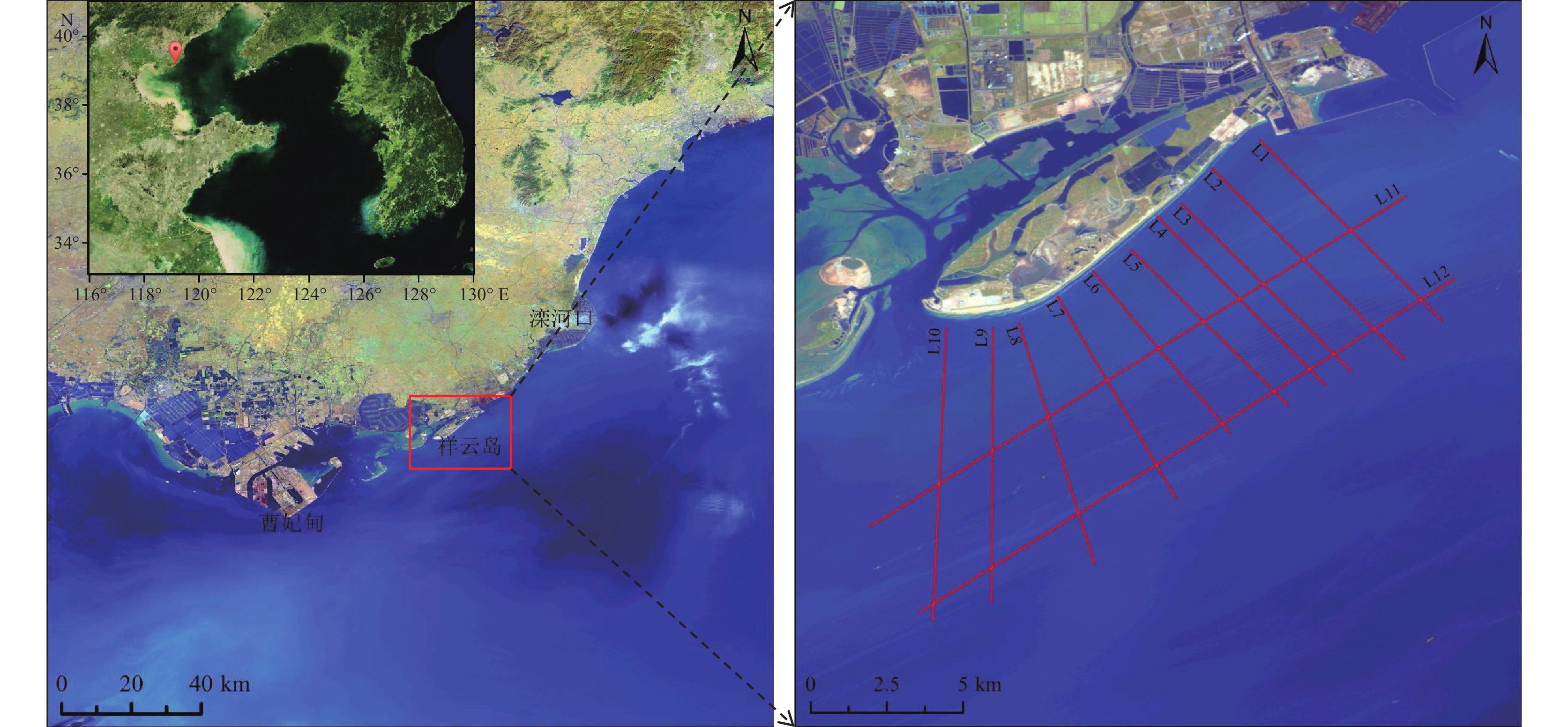
2019年7月25—28日,在祥云岛海域开展走航式ADCP测量。如图1所示本次测量共设计12条测线,其中测线L1~L10垂直于岸滩分布,平均测线长度约8.0 km;测线L11、L12平行于祥云岛分布,平均测线长度为17.5 km。由于祥云岛潮间带平缓,近岸段水深较浅,测量船容易发生触底的危险。为确保调查过程中设备和人员的安全,选择高潮位时间段进行垂直于岸线的测线测量。根据中国地质调查局天津地质调查中心在津冀沿海的潮汐站监测系统(李勇等,2020),各测线测量时间与潮位对应关系如图2所示。
2.3 参数设置
走航式ADCP测量采用美国TRDI公司生产的瑞江牌(WHR600)声学多普勒流速剖面仪,具有4个换能器,主要技术指标有:工作频率600 kHz;换能器发射角度20°测速范围为±0.01~±10 m/s(水平方向),速度分辨率0.25 cm/s;测深范围:0.75~100 m。本次调查过程中ADCP换能器入水深度为1.10 m,波束角为20°;水流层数设置为50,层厚0.50 m,第一层中心位置为1.96 m。
3. 结果与分析
祥云岛位于半封闭的渤海内部,潮汐类型属于不规则半日潮,测量期间平均潮差0.79 m。测线L1、L3、L5~L7及L10~L12测量期间为涨潮期;测线L2、L4、L8及L9测量期为落潮期(图2)。
3.1 测量结果质量控制
现场流速测量过程中受风浪等环境的干扰,测量数据会出现明显的噪点。因此,数据分析前需要将这部分数据剔除。为控制测量数据质量,本次调查将满足回波强度(Echo Intensity)为50~200 counts,相关系数(correlation)为50~200,良好百分比检验参数大于50%的数据作为有效数据,其余数据予以剔除(杨锦坤等,2009)。通常认为ADCP单次回波所测的流速误差比较大,一般使用一段时间的平均流速来表示某一点或时刻的流速,ADCP流速的平均时间可根据具体情况而定(吴云帆等,2014)。本次测量数据中参与平均的呯(ping)集合数为20(测量时船速约2.1 m/s,相当于平均时长为1 min,平均距离约50 m)。
3.2 祥云岛海域流速特征
3.2.1 海流流向特征
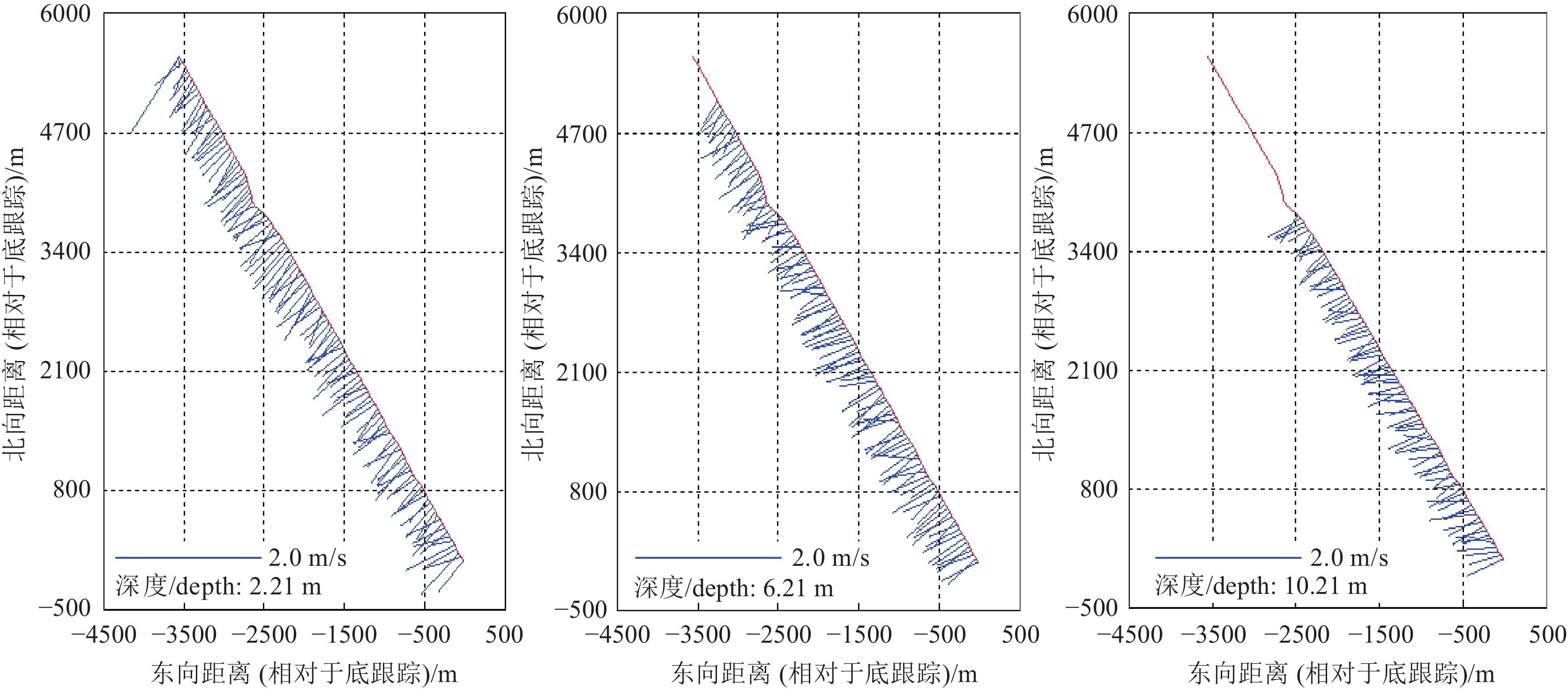
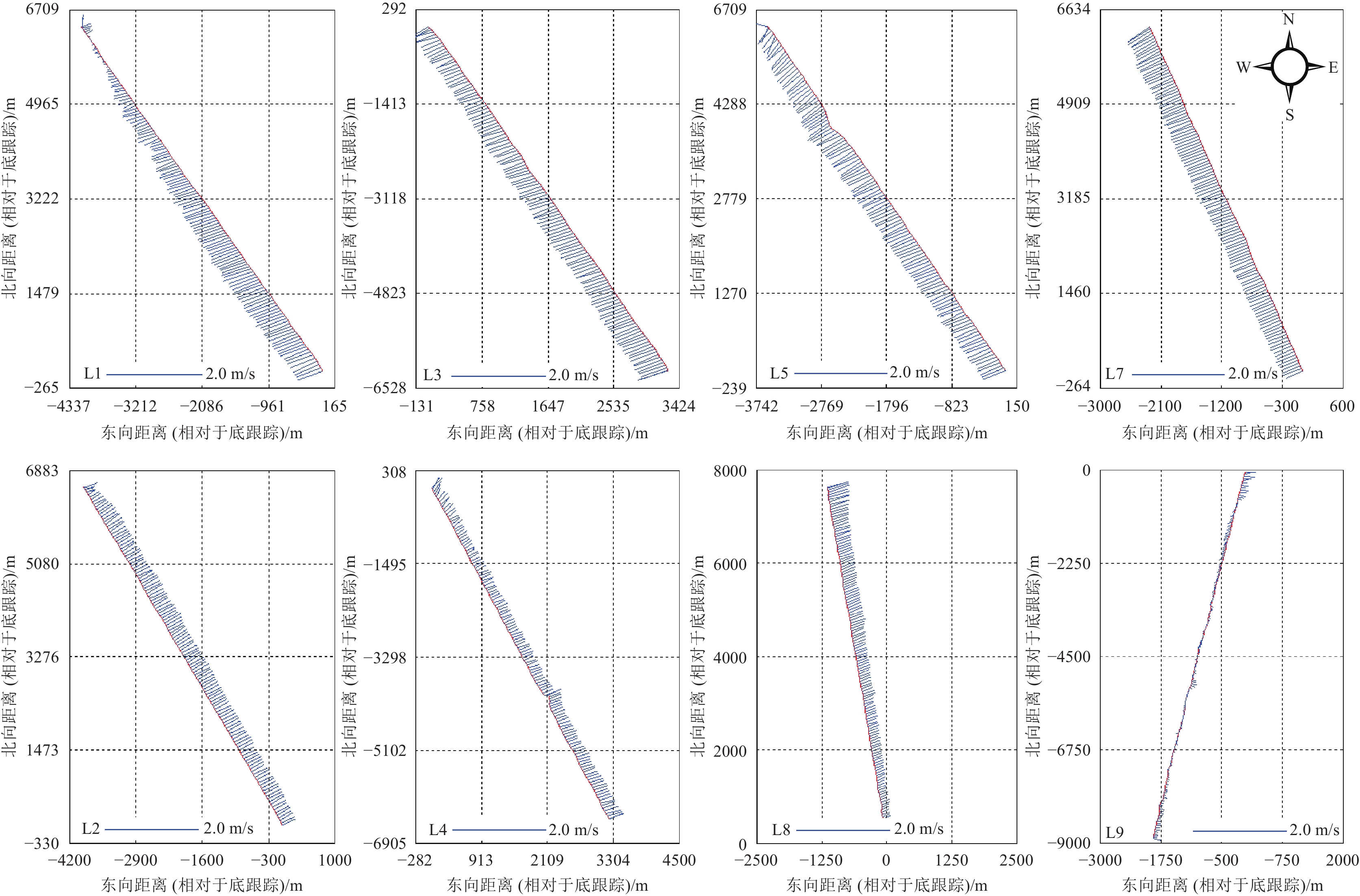
走航式ADCP获得沿测线方向的全水深流速,为更直观地显示剖面流速流向特征,本文选取表、中、底不同深度的海流进行分析。如图3所示,测线L5不同深度水层(水深2.21 m、6.21 m、10.21 m)的航迹和流速矢量图结果表明,在涨、落潮阶段海流流向在不同深度水层的流向基本保持一致。对海流流向沿深度方向求均值,如图4所示:测线L1、L3、L5和L7为涨潮期(图4a),涨潮流为SW方向;测线L2、L4和L8为落潮期(图4b),落潮流为NE方向。因此,祥云岛外海海域流向具有明显的往复特征,海流流向以NE−SW为主,基本与祥云岛岸线平行。
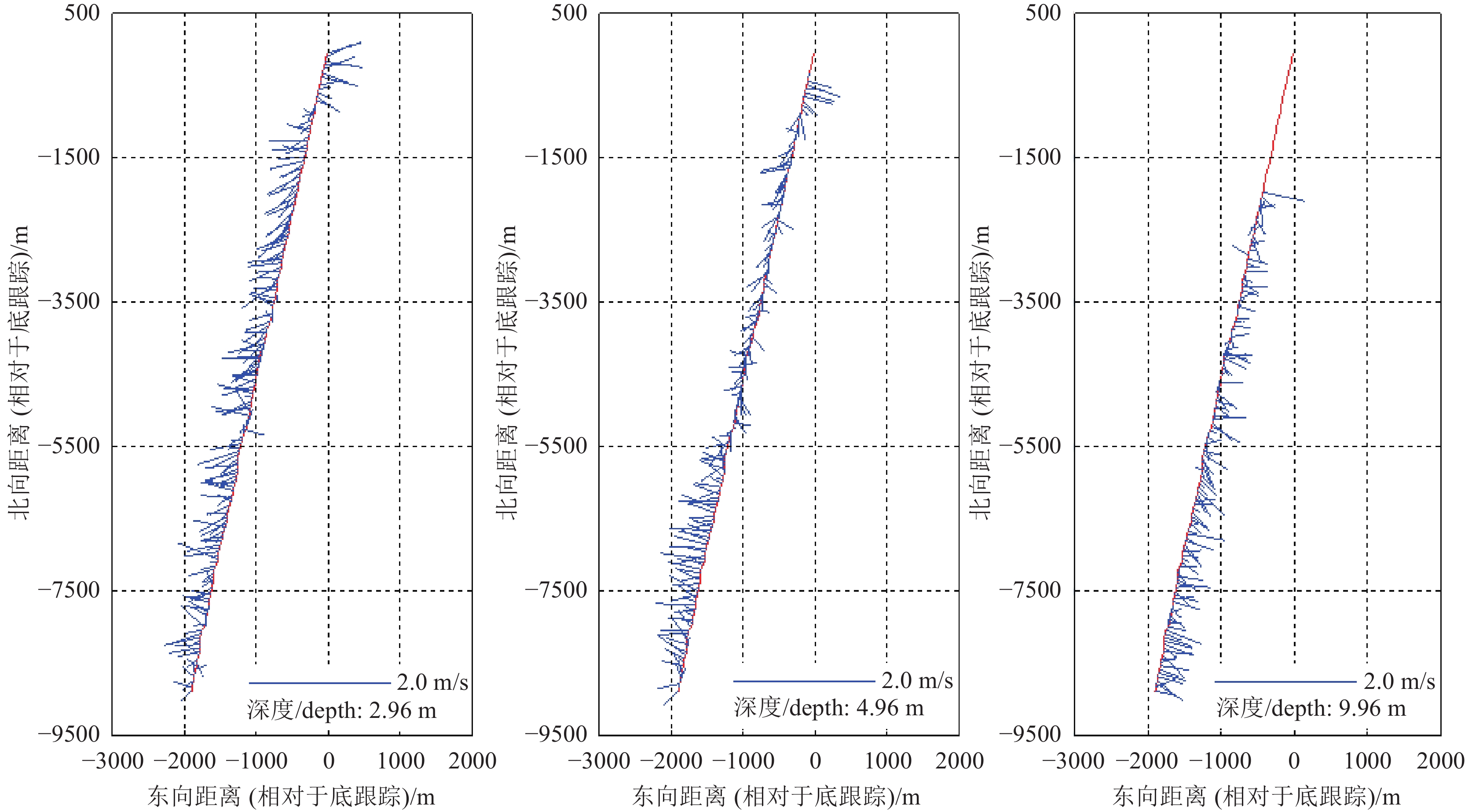
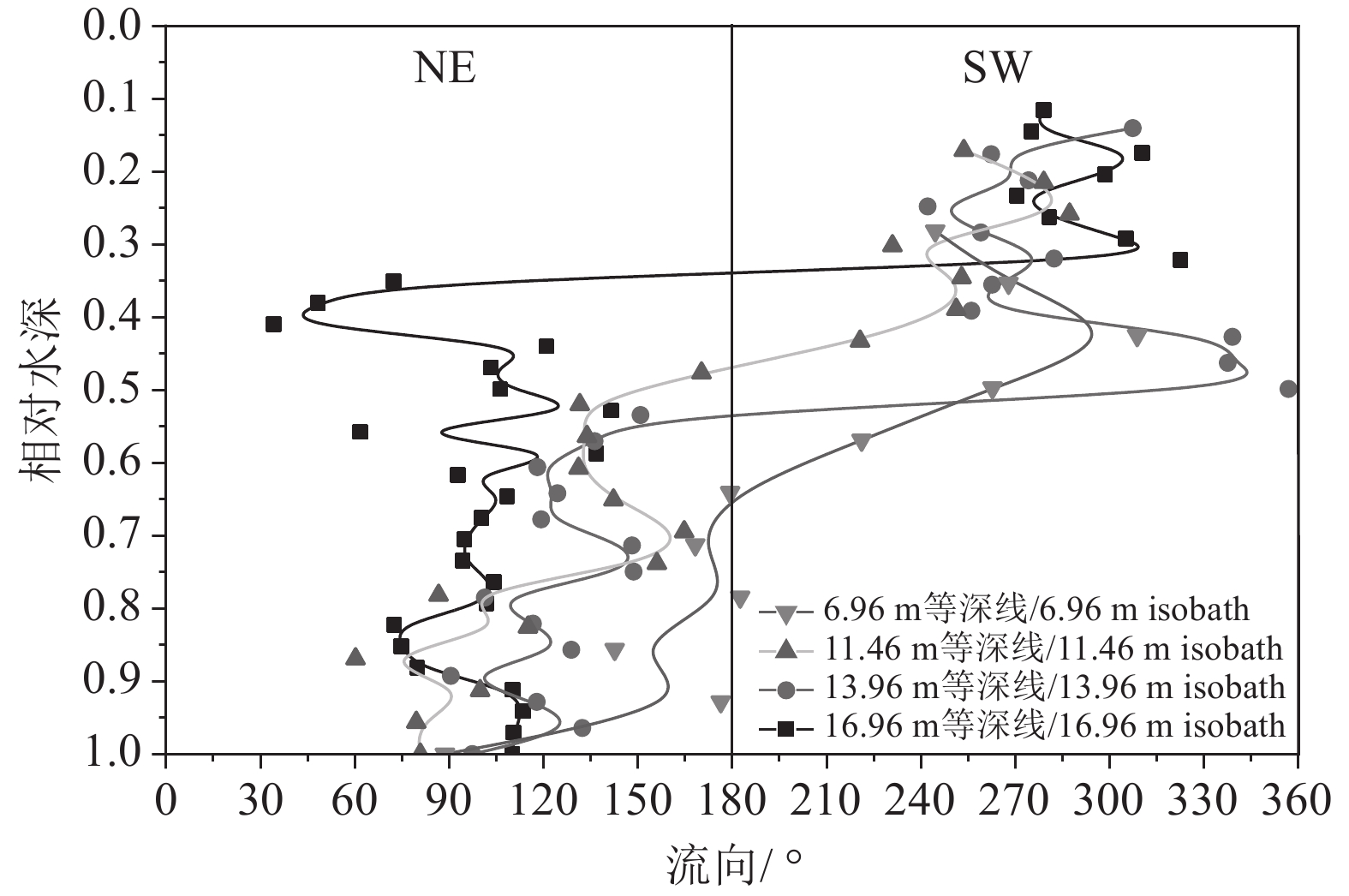
图2潮位信息显示,测线L9测量时间为平潮转落潮期,其全水深平均流向并没有表现为明显的NE方向(图4b),测线L9不同深度水层航迹和流速矢量结果如图5所示,在浅表层(2.96 m水深),近岸段流速方向为NE向,沿离岸方向流速方向为SW向,水深4.96 m水层流速矢量表明离岸段流向为SW向,水深9.96 m水层显示流速流向在整个测线上均表现为NE方向,与落潮流的方向保持一致。这表明在平潮转为落潮期间,海流转向始于底部海水,且海流转向与潮位变化具有一定的滞后性。为更清晰地描述这一问题,取测线L9不同等深线处海流流向数据绘制流向剖面分布图,如图6所示:相对水深(流速测量点水深/全水深)大于0.5时,海流流向为NE向,小于0.5是海流流向为SW向;测线L9由近岸向离岸方向测量,潮位逐渐由平潮转为落潮,沿等深线增加方向(离岸方向),流速转向的相对深度逐渐减小,再次证明该海域平潮转为落潮期间海流转向始于底层海水。
3.2.2 海流流速特征
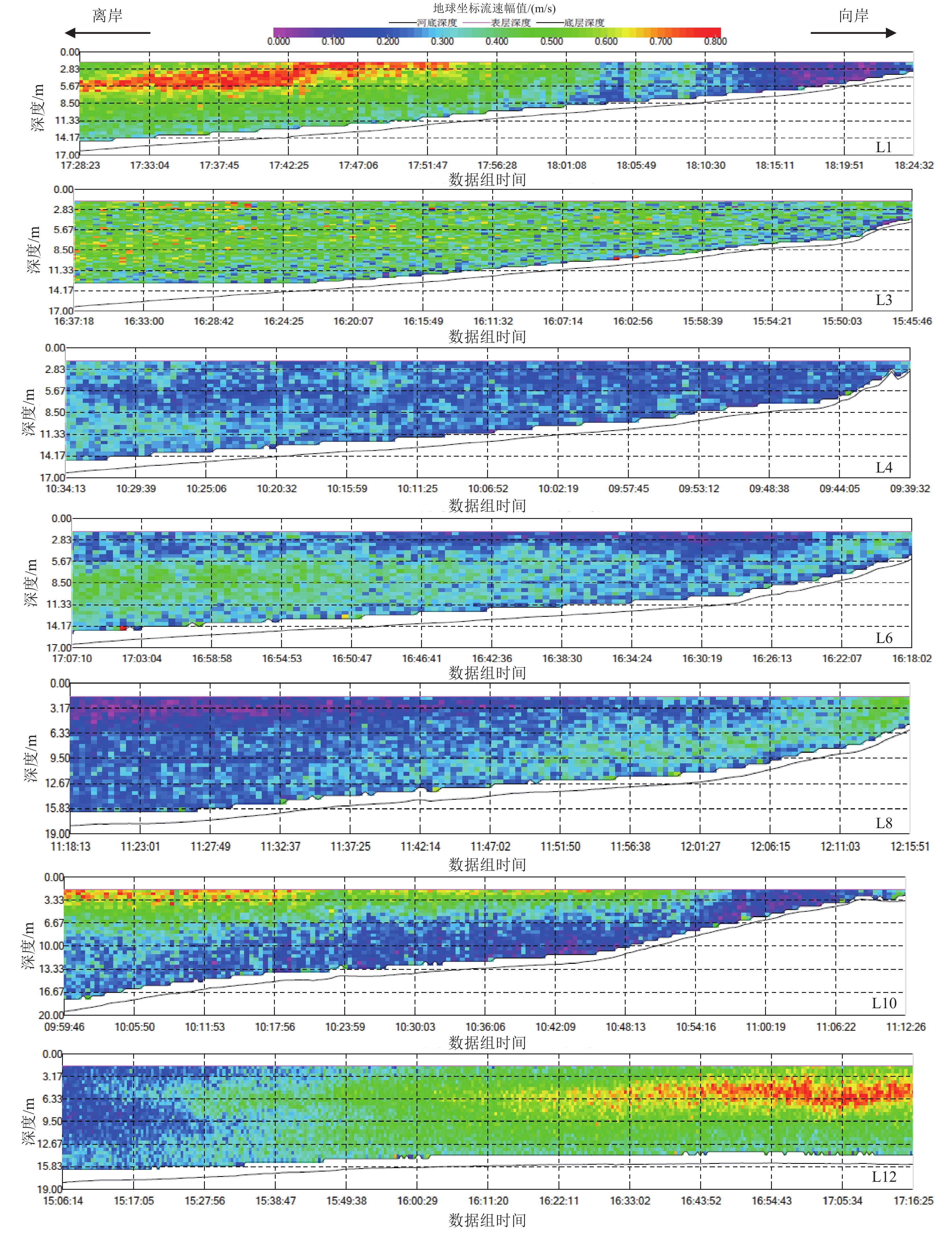
本文选取涨落潮期间典型剖面流速幅值进行对比分析,测线L1、L3、L6和L10为涨潮期、测线L4和L8为落潮期,各测线流速幅值剖面分布如图7所示。涨潮期间,测线 L1位于祥云岛东北端,离岸方向距离海底约11 m高度处有一层相对稳定的高流速层,流速可达0.7~0.8 m/s,向祥云岛滩面方向水深逐渐变浅,水深小于11 m时,该高流速层减弱;测线L10位于祥云岛西南端,其流速特征与测线L1类似,流速沿向岸方向逐渐降低;测线L3流速幅值相对均匀,垂向和向岸方向流速变化不明显;测线L6流速幅值沿向岸方向呈现明显减小的趋势。结果表明:涨潮流流速沿向岸方向逐渐减小;相对于祥云岛东北和西南段,中部流速幅值整体偏小,测线L3和L6涨潮流离岸端流速可达到0.5 m/s以上。测线L4和L8位于祥云岛中部,其流速幅值明显小于测线L3和L6,祥云岛岸段落潮流速明显低于涨潮流速,而测线L8在近岸段的流速要明显大于离岸段。
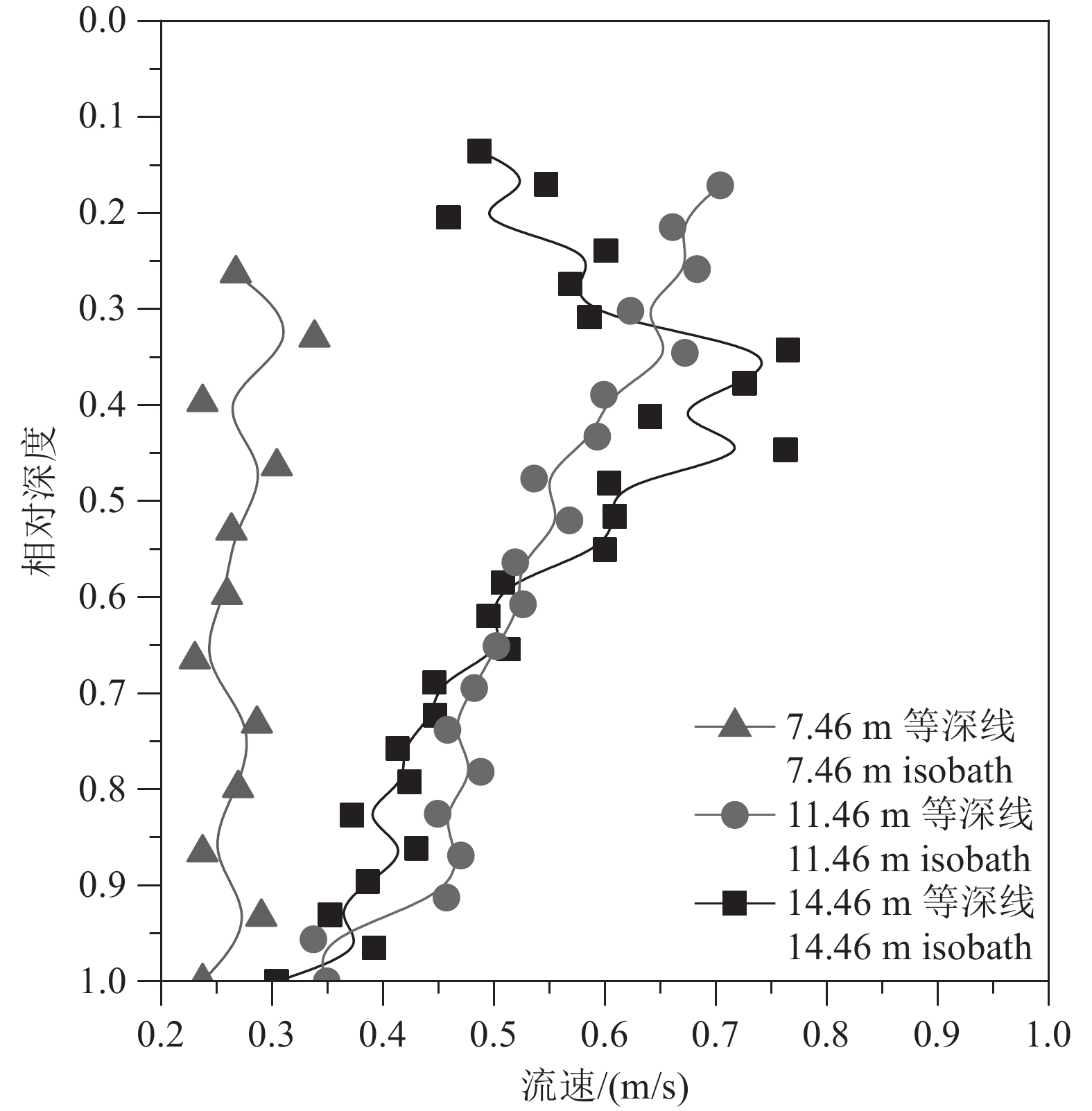
测线L11与L12均位于涨潮期,涨潮过程中测线L12在时间上更接近于L1和L10(图2)。 以测线L12为例(图7)平行于祥云岛方向,涨潮期间祥云岛东北端存在明显的高流速层,高流速层位于距离海底约11 m处,这与测线L1的测量结果是一致的。为更直观地展现高流速层的分布形态,本文以测线L1为例,取测线L1中不同等深线(14.46 m、11.46 m和7.46 m)处的流速剖面进行对比,如图8所示。离岸方向等深线测量点数值越大,14.46 m处流速剖面结构表现为抛物线型,表明该处存在明显的高流速层,向岸方向,水深减小(7.46 m),流速剖面垂向分布趋于均匀,11.46 m处为过渡段,流速剖面表现为斜直线型。
3.3 祥云岛近岸悬浮沉积物分布
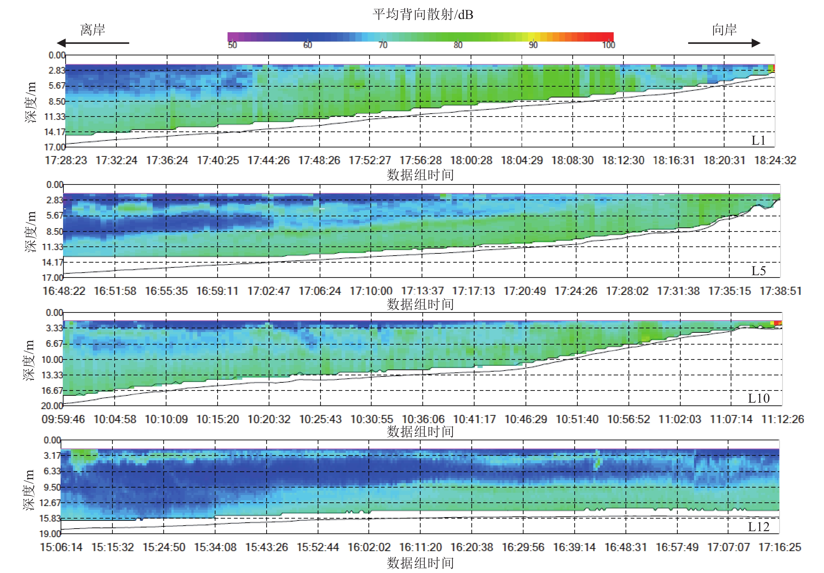
本次测量中未进行同步取样测试,未能建立背向散射强度与悬浮沉积物的回归公式。如前所述,ADCP记录的声学背向散射强度数据能够在一定程度上定性反映祥云岛周边海域的悬浮沉积物分布情况。本次测量中船载走航式ADCP记录了航测过程中的背向散射强度,以涨潮期间测线L1、L5、L10及L12为例,如图9所示。
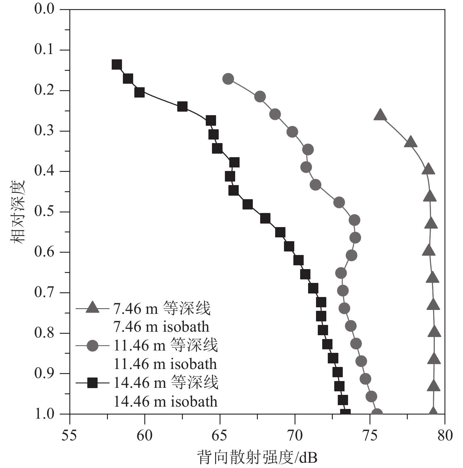
涨潮期间祥云岛不同位置背向散射强度剖面的分布结果(图9)显示,祥云岛近底普遍存在一层高悬浮沉积物层,且向岸方向悬浮沉积物浓度逐渐增加。图10为测线L1中不同等深线处(14.46 m、11.46 m和7.46 m)的背向散射强度分布对比图,更直观地反映了悬浮沉积物向岸方向增加的现象。测线L12平行于祥云岛方向,沿NE方向在近底逐渐出现一层悬浮沉积物层,高悬浮沉积物浓度层的出现与流速分布(图7,测线L12)具有很好的一致性;水体中悬浮沉积物的维持需要一定的流速,流速幅值为0.30~0.60 m/s时,水体中更容易形成一层稳定的悬浮沉积物层。沿祥云岛岸线由东北向西南方向,流速降低相应的悬浮沉积物浓度也降低,表明悬浮沉积物在向西南方向输运过程中发生沉积。
3.4 悬浮沉积物输运对岸线蚀退的影响
祥云岛是滦河早期从大清河口、长河口入海时建造的沙坝(高善明,1981),自滦河迁徙改道北移入海之后,陆源泥沙来源断绝,加之京唐港的修建,港口防沙堤不断向海延伸,截断了沿岸泥沙的补给,之后祥云岛岸线急剧退化。研究表明1987—2000年,祥云岛岸线呈现出北部侵蚀、南部淤积的状态,岸线变化速率分别为−9.20~+10.40 m/a;2000年以后,北部约1500 m砂质岸线转变为港口围堤,被京唐港扩建、祥云湾码头占用,在沿岸流作用下祥云岛东北段泥沙向西南段运移,引起西南段淤积(邢容容等,2017)。邱若峰等(2010)指出祥云岛西南端的金沙岛岸段,自1987年以来向海拓展22 m,该岸段向海推进的一个重要原因在于人为的吹沙造陆,使得该岸段泥沙补给充足(陈文超等,2016)。 本文测量结果显示祥云岛近海海域涨潮流速(SW向)大于落潮流速(NE向)且祥云岛东北端悬浮沉积物大于西南段悬浮沉积物。这表明目前祥云岛近岸海域的悬浮沉积物整体沿NE−SW方向进行运移,与目前祥云岛岸线的侵蚀现状是一致的。
此外,祥云岛海洋牧场于2007年开始申报建设,牧场位于京唐港西南的祥云湾外海海域,水深7~15 m等深线范围内。海洋牧场建设在其规划海域内投放了包括水泥沉箱、水泥铸块、花岗岩石礁、钢筋板框、船礁等在内的各类人工渔礁共计约20万m3(王湛,2018)。人工渔礁的投放必然对近岸海域的流场产生影响,天津地质调查中心2018年的模拟结果显示,人工渔礁的投放仅对投放区周围两倍面积范围内的流场有影响,并导致明显的侵蚀淤积现象
1 。但该结果尚缺乏现场实测数据支撑,有关海洋牧场建设对海域流场的影响,还需要后续海洋牧场建成后的持续跟踪调查。4. 结 论
利用走航式ADCP在祥云岛海域开展流速、流向及悬浮沉积物浓度等水文要素测量,该方法较传统的定点观测和取样测试,具有不扰动流场、测量历时短、测量范围大、充分利用航时等特点,效率大幅提升。测量结果显示:
(1)祥云岛海域海流以平行于岸线为主,具有明显的往复性,该区域涨潮流明显大于落潮流,涨潮流沿向岸方向逐渐减弱,祥云岛西南部局部落潮流存在向岸方向增强的现象。
(2)祥云岛海域在平潮向落潮过渡期间,海流转向始于底部海水,且海流转向与潮位变化具有一定的滞后性。
(3)测量期间背向散射强度数据表明,祥云岛近岸海域存在明显的高浓度层,且沿向岸方向浓度增加,平行于祥云岛岸线方向,悬浮沉积物浓度由东北向西南方向逐渐降低。
(4)祥云岛近岸海域在涨落潮流的作用下,悬浮沉积物沿祥云岛岸线由东北向西南运移,是导致祥云岛岸线在东北段侵蚀、西南段淤积的主要原因之一。
-
图 1 扬子及周边地区新元古代裂谷分布图(修改自万天丰, 2011;管树巍等,2017;杜远生等,2018)
I—鄂湘黔桂裂谷系;II—扬子北缘裂谷系;III—川中裂谷系;IV—康滇裂谷系
Figure 1. Distribution map of Neoproterozoic rift valleys in Yangtze and surrounding areas (modified from Wan Tianfeng, 2011;Guan Shuwei et al., 2017;Du Yuansheng et al., 2018)
I−Hubei−Hunan−Guizhou−Guangxi Rift System; II−Northern Yangtze Rift System; III−Central Sichuan Rift System; IV−Tibet−Yunnan Rift System
图 3 中上扬子地区新元古界出露地区及剖面点分布图
剖面(钻孔)名称:1—酉阳獠牙盖;2—秀山小茶园;3—秀山孝溪;4—秀山笔架山;5—秀山兰桥;6—松桃大塘坡;7—松桃杨家湾;8—松桃寨英;9—江口桃映;10—万山石竹溪;11—新晃板桥;12—洪江托口;13—神农架蚂蟥沟;14—秭归青林口;15—长阳流溪;16—长阳杨树坳;17—鹤峰走马;18—沅陵军大坪;19—桃源马金洞;20—安化龙塘;21—宁乡菜花田;22—湘锰锰矿;23—江口堰溪;24—印江永义;25—松桃石塘锰矿;26—松桃道陀;27—花垣两河乡;28—花垣民乐;29—古丈鬼溪;30—古丈烂泥田;31—遵义松林六井;32—开阳马路坪;33—余庆朵丁;34—石阡窑上;35—石阡龙家屋基;36—镇远松柏洞;37—剑河八卦河;38—湘西黔阳;39—怀化新路河
Figure 3. Distribution map of Neoproterozoic outcropping areas and profile points in the Middle—Upper Yangtze Region
Profile (drill) name: 1–Liaoyagai, Youyang;2–Xiaochayuan, Xiushan;3–Xiaoxi, Xiushan;4–Bijiashan, Xiushan;5–Lanqiao, Xiushan;6–Datangpo, Songtao;7–Yangjiawan, Songtao;8–Zhaiying, Songtao;9–Taoying, Jiangkou;10–Shizhuxi, Wanshan;11–Banqiao, Xinhuang;12–Tuokou, Hongjiang;13–Mahuanggou, Shennongjia;14–Qinglinkou, Zigui;15–Liuxi, Changyang;16–Yangshuao, Changyang;17–Zouma, Hefeng;18–Jundaping, Yuanling;19–Majindong, Taoyuan;20–Longtang, Anhua;21–Caihuatian, Ningxiang;22–Manganese ore, Ningxiang;23–Yanxi, Jiangkou;24–Yongyi, Yinjiang;25–Shitang manganese ore, Songtao;26–Daotuo, Songtao;27–Lianghe, Huayuan;28–Minle, Huayuan;29–Guixi, Guzhang;30–Lannitian, Guzhang;31–Songlin Well6#, Zunyi;32–Maluping, Kaiyang;33–Duoding, Yuqing;34–Yaoshang, Shiqian;35–Longjiawuji, Shiqian;36–Songbaidong, Zhenyuan;37–Baguahe, Jianhe;38–Qianyang, Xuangxi;39–Xinluhe, Huaihua
图 4 中上扬子地区大塘坡组露头及岩心特征
a—大塘坡组一段碳质页岩,夹于南沱组与古城组冰碛砾岩之中,厚度小于5 m,局限陆棚相,神农架宋洛蚂蟥沟;b—贵州松桃道陀ZK001钻孔大塘坡组一段岩心,局限陆棚相;①黑色碳质页岩,见星点状黄铁矿;②黑色、钢灰色条带状菱锰矿;③黑色碳质页岩、泥岩、硅质岩;④黑色块状菱锰矿夹碳质页岩,见星点状黄铁矿;⑤黑色含锰碳质页岩;⑥黑色块状菱锰矿夹黑色碳质页岩,见星点状黄铁矿;⑦黑色碳质页岩;c—大塘坡组一段,粉砂岩发育脉状层理,潮坪相,贵州江口堰溪;d—大塘坡组一段,细砂岩中发育交错层理,浅水陆棚相,汉中钢厂;e—大塘坡组一段,碳质页岩中见宏体化石,局限陆棚相,神农架宋洛蚂蟥沟; f—大塘坡组一段含砾粉砂岩,海滩及障壁岛相,贵州松桃西溪堡(b图据安正泽,2014等;c、f图据张予杰等,2020,d、e图据张高冲,2020)
Figure 4. Characteristics of outcrops and cores of the Datangpo Formation in the Middle and Upper Yangtze Region
a–Carbonaceous shale of the first member of the Datangpo Formation, sandwiched between the moraine conglomerate of the Nantuo Formation and Gucheng Formation, with a thickness of less than 5 m, limited shelf facies, Songluo Majigou, Shennongjia; b–ZK001 of Songtao Daotuo manganese ore, Guizhou; The core of the first member of the Datangpo Formation, limited shelf facies; ①The black carbonaceous shale showed star–shaped pyrite; ②The black and steel gray banded rhodochrosite; ③Black carbonaceous shale, mudstone, siliceous rock; ④Black massive rhodochrosite with carbonaceous shale, with star–shaped pyrite; ⑤Black manganese—bearing carbonaceous shale; ⑥Black massive rhodochrosite with black carbon shale and star–shaped pyrite; ⑦black carbonaceous shale; c–The first member of the Datangpo Formation, siltstone developed vein bedding, tidal flat facies, Yanxi, Jiangkou, Guizhou; d– The first member of Datangpo Formation, with cross bedding developed in fine sandstone, shallow–water shelf facies, Hanzhong Steel Works; e–The first member of Datangpo Formation, macrofossils are seen in carbonaceous shale, limited shelf facies, Mahuanggou, Songluo, Shennongjia, Hubei; f–The first member of the Datangpo Formation, gravel–bearing siltstone, beach and barrier island facies, Xixibao, Songtao, Guizhou (fig.4b after An Zhengze et al., 2014;fig.4c,f after Zhang Yujie et al., 2020, fig.4d,e after Zhang Gaochong, 2020)
图 15 中上扬子地区大塘坡组碳质页岩扫描电镜下孔隙形态
a—凹凸接触的钠长石颗粒发育溶蚀孔及粒缘缝;b—黄铁矿晶体被溶蚀后形成的铸模孔集合体;c—填隙状有机质发育少量孔隙;见微晶钾长石颗粒;d—填隙状有机质发育少量孔隙
Figure 15. Pore morphology of carbonaceous shale of Datangpo Formation in the Middle—Upper Yangtze Region
a–The albite grains in contact with the concave—convex develop dissolution pores and grain boundary fractures; b–The aggregates of mold pores formed after the dissolution of the pyrite crystals; c–The interstitial organic matter develops a small amount of pores; see microcrystalline potassium feldspar grains ; d–Interstitial organic matter with a small amount of pores
图 16 中上扬子地区大塘坡组成藏组合模式图
Nh2g—南华系古城组;Nh2d1—2—南华系大塘坡组一段~二段;Nh3n—南华系南沱组;Z1ds—南华系陡山沱组;Z1dn1~4—南华系灯影组一段~四段;Є1n1~3—寒武系牛蹄塘组一段~三段
Figure 16. Datangpo Formation and hydrocarbon accumulation assemblage model in the Middle and Upper Yangtze Region
Nh2g−Gucheng Formation, Nanhua System; Nh2d1~2−The first and second member of Datangpo Formation, Nanhua System; Nh3n−Nantuo Formation, Nanhua System; Z1ds−Doushantuo Formation, Sinian System; Z1dn1~4−The first~fourth member of Dengying Formation, Sinian System; Є1n1~3− The first~third member of Niutitang Formation, Cambrian System
表 1 中上扬子地区大塘坡组沉积体系划分表
Table 1 Sedimentary system classification of Datangpo Formation in Middle—Upper Yangtze Region
相 亚相 微相 岩石组合 沉积构造 水体能量 滨岸 海滩及障壁岛 后滨 中粗砂岩、含砾砂岩 小型交错层理 低能 前滨 含砾中砂岩、石英砂岩 交错层理、冲洗层理 中高能 临滨 中细砂岩、粉砂岩 交错层理、水平层理 中低能 潮坪 潮上带 泥岩、粉砂质泥岩、盐岩 暴露构造 低能 潮间带 粉砂岩、粉砂质泥岩、砂质泥岩 脉状层理、波状层理、
透镜状层理中低能 潮下带 粗粉砂岩夹泥岩、中粗砂岩 大型交错层理 中高能 潟湖 / 粉砂质泥岩、钙(泥)质粉砂岩、
含碳锰粉砂质泥岩、菱锰矿水平层理,小型韵律层理 低能 陆棚 浅水陆棚 浅滩 细砂岩、石英砂岩、岩屑石英砂岩 大型交错层理、浪成层理 中高能 平原 砂质页岩、粉砂质泥岩、含钙粉—细砂岩、含砂灰(云)岩、
泥晶灰(云)岩小型交错层理、水平层理 中低能 局限陆棚 斜坡 含粉砂碳质页岩、含锰碳质页岩、
含锰云(灰)岩牵引流构造 低能 盆洼 菱锰矿、碳质页岩、含锰碳质页岩、沉凝灰岩 水平纹层、页理 内隆 含锰碳粉砂质页岩、含锰白云岩 水平层理 水下隆起 障壁砂坪 中细砂岩、粉砂岩 交错层理、水平层理 中低能 障壁云坪 含砾白云质砂岩、含砾砂质白云岩、含砂白云岩 水平层理 深水陆棚 / 钙质泥岩、硅质泥岩 浊流构造 低能 表 2 中上扬子地区大塘坡组有机地球化学特征及其对比
Table 2 Organic geochemical characteristics of the Datangpo Formation in the Middle—Upper Yangtze Region and comparison with other organic shales
地层 地区 有机碳/% 生烃潜量
S1+S2/(mg·g–1)成熟度
Ro/%干酪根δ13C/
‰沉积相 来源 大
塘
坡
组松桃寨英 3.05~6.29(4.32) 0.001~0.051(0.013) 2.19~2.47(2.34) –32.9 ~ –32.4 局限陆棚 谢增业等,2017 秀山千子门 0.43~4.47(2.19) 0.005~0.029
(0.014)2.84 / 潮坪—潟湖 秀山小茶园 3.47~8.5
(4.72)0.046~0.096
(0.016)3.09 / 潟湖—局限陆棚 秀山大、小茶园 0.25~15.86
(4.80)0.002~0.043
(0.014)2.02~2.37 –33.8 ~ –33.9 潟湖—局限陆棚 张健等,2015 神农架宋洛 4.55 0.17 3.37 –28.41 浅水陆棚—局限
陆棚实测 陡山沱组 宜昌长阳 0.5~6.1
(2.1)0.01~1.54
(0.23)1.9~3.5(3.3) / 台内盆地 实测 牛蹄塘组 宜昌长阳 1.5~5.0
(3.6)0.03~0.81
(0.34)2.5~3.2(2.9) / 深水陆棚 实测 注:数据格式为:最大值~最小值(平均值)。 -
[1] An Zhengze, Zhang Renbiao, Chen Jiacai, Qin Ying, Pan Wen, Wu Guiwu, Peng Qianyun, Zheng Chao, Zhang Feifei, Zhu Xiangkun, Wang Haibin. 2014. Geological and geochemical characteristics of Daotuo superlarge manganese bore deposit in Songtao County of Guizhou Province: Constraint on formation mechanism of Mn—carbonate ores[J]. Mineral Deposits, 33(4): 870−884 (in Chinese with English abstract).
[2] Chen Jianshu, Dai Chuangu, Peng Chenglong, Wang Min, Lu Dingbiao, Wang Xuehua, Luo Shan. 2016. The filling sequence and stratigraphic framework of rift basin during the Neoproterozoic 820–635Ma in Hunan, Guizhou and Guangxi[J]. Geology in China, 43(3): 899−920 (in Chinese with English abstract).
[3] Dan Yong, Yan Jianfei, Bao Shujing, Liang Bin, Ma Long, Nie Guoquan, Cao Junfeng, Ji Shaocong, Han Kai. 2023. Discovery of Sinian–Cambrian multi–tier shale gas in Guidandi–1 well of southwest margin of Xuefeng uplift[J]. Geology in China, 50(1): 291−292 (in Chinese).
[4] Du Yuansheng, Zhou Qi, Yu Wenchao, Wang Ping, Yuan Liangjun, Qi Jing, Guo Hua, Xu Yuan. 2015. Linking the cryogenian manganese metallogenic process in the southeast margin of Yangtze Block to break–up of Rodinia Supercontinent and Sturtian Glaciation[J]. Geological Science and Technology Information, 34(6): 1−7 (in Chinese with English abstract).
[5] Du Yuansheng, Zhou Qi, Yu Wenchao, Zhang Yaguan, Wang Ping, Qin Yongjun, Pang Dawei. 2018. Sedimentary geotectonics and its control function of sedimentary mineral in Nanhua Period−Sinian Period in Guizhou[J]. Guizhou Geology, 35(4): 282−290 (in Chinese with English abstract).
[6] Evans D A D. 2000. Stratigraphic, geochronological, and paleomagnetic constraints upon the Neoproterozoic climatic paradox[J]. American Journal of Science, 300(5): 347−433.
[7] Guan Shuwei, Wu Lin, Ren Rong, Zhu Guangyou, Peng Chaoquan, Zhao Wentao, Li Jie. 2017. Distribution and petroleum prospect of Precambrian rifts in the main cratons, China[J]. Acta Petrolei Sinica, 38(1): 9−22 (in Chinese with English abstract).
[8] Li Xianhua, Wang Xuance, Li Wuxian, Li Zhengxiang. 2008. Petrogenesis and tectonic significance of Neoproterozoin basaltic rocks in South China: From orogenesis to intracontinental rifting[J]. Geochimica, 37(4): 382−398 (in Chinese with English abstract).
[9] Lund K, Aleinikoff J N, Evans K V, Fanning C M. 2003. SHRIMP U–Pb geochronology of Neoproterozoic Windermere Supergroup, central Idaho: Implications for rifting of western Laurentia and synchroneity of Sturtian glacial deposits[J]. Geological Society of America Bulletin, 115(3): 349−372.
[10] Ma Zhixin, Luo Liang, Liu Xiting, Liu Wei, Sun Zhiming. 2016. Palaeoenvironment of the Datangpo Formation of Nanhua System in Xiaochayuan Manganese Deposit in Xiushan area of Chongqing[J]. Journal of Palaeogeography, 18(3): 473−485 (in Chinese with English abstract).
[11] Qi Jing, Yu Wenchao, Du Yuansheng, Zhou Qi, Guo Hua, Wang Jiawu, Wang Ping, Xu Yuan. 2015. Paleoclimate evolution of the cryogenian Tiesi’ao Formation–Datangpo Formation in Eastern Guizhou Province: Evidence from the chemical index of alteration[J]. Geological Science and Technology Information, 34(6): 47−57 (in Chinese with English abstract).
[12] Tan Mantang, Lu Zhixiong, Zhang Yan. 2009. Preliminary analysis on genesis of manganese deposit in Datangpo Formation, West Hubei Province[J]. Resources Environment & Engineering, 23(2): 108−113 (in Chinese with English abstract).
[13] Wang Jian, Liu Baojun, Pan Guitang. 2001. Neoproterozoic rifting history of south china significance to rodinia breakup[J]. Journal of Mineralogy and Petrology, 21(3): 135−145 (in Chinese with English abstract).
[14] Wang Jian, Duan Taizhong, Xie Yuan, Wang Zhengjiang, Hao Ming, Liu Wei. 2012. The tectonic evolution and its oil and gas prospect of southeast margin of Yangtze Block[J]. Geological Bulletin of China, 31(11): 1739−1749 (in Chinese with English abstract).
[15] Wang X L, Zhou J C, Qiu J S, Zhang W L, Liu X M, Zhang G L. 2006. LA–ICP–MS U–Pb zircon geochronology of the Neoproterozoic igneous rocks from Northern Guangxi, South China: Implications for tectonic evolution[J]. Precambrian Research, 145(1/2): 111−130.
[16] Wang Xingui, Wang Chaoyong, Dou Luxing. 2015. Shale gas condition and potential in Datangpo Formation of Nanhua System on the southeast of Sichuan Basin[J]. Science Technology and Engineering, 15(17): 113−116 (in Chinese with English abstract).
[17] Wang Zecheng, Jiang Hua, Wang Tongshan, Gu Zhidong, Huangshipeng. 2014. Hydrocarbon systems and exploration potentials of Neoproterozoic in the Upper Yangtze Region[J]. Natural Gas Industry, 34(4): 27−36 (in Chinese with English abstract).
[18] Wang Zecheng, Liu Jingjiang, Jiang Hua, Huang Shipeng, Wang Kun, Xu Zhengyu, Jiang Qingchun, Shi Shuyuan, Ren Mengyi, Wang Tianyu. 2019. Lithofacies paleogeography and exploration significance of Sinian Doushantuo depositional stage in the middle–upper Yangtze region, Sichuan Basin, SW China[J]. Petroleum Exploration and Development, 46(1): 39−51 (in Chinese with English abstract).
[19] Wan Tianfeng. 2011. The Tectonics of China [M]. Beijing: Geological Publishing House, 65–67 (in Chinese).
[20] Wei Guoqi, Yang Wei, Zhang Jian, Xie Wuren, Zeng Fuying, Su Nan, Jin Hui. 2018. The pre–Sinian rift in central Sichuan Basin and its control on hydrocarbon accumulation in the overlying strata[J]. Petroleum Exploration and Development, 45(2): 179−189 (in Chinese with English abstract).
[21] Xie Zengye, Wei Guoqi, Zhang Jian, Yang Wei, Zhang Lu, Wang Zhihong, Zhao Jie. 2017. Characteristics of source rocks of the Datangpo Fm, Nanhua System, at the southeastern margin of Sichuan Basin and their significance to oil and gas exploration[J]. Natural Gas Industry, 37(6): 1−11 (in Chinese with English abstract).
[22] Yin Chongyu, Wang Yangeng, Tang Feng, Wan Yusheng, Wang Ziqiang, Gao Linzhi, Xing Yusheng, Liu Pengju. 2006. SHRIMP Ⅱ U–Pb zircon date from the Nanhuan Datangpo Formation in Songtao County, Guizhou Province[J]. Acta Geologica Sinica, 80(2): 273−278 (in Chinese with English abstract).
[23] Zhai Gangyi, Bao Shujing, Wang Yufang ChenKe, Wang Shengjian, Zhou Zhi, Song Teng, Li Haohan. 2017. Reservoir accumulation model at the edge of palaeohigh and significant discovery of shale gas in Yichang Area, Hubei Province[J]. Acta Geoscientica Sinica, 38(4): 441−447 (in Chinese with English abstract).
[24] Zhang Gaochong. 2020. Sedimentary Facies and Lithofacies Paleogeography of the Nanhua System Datangpo Formation on the Northern Margin of the Yangtze Platform[D]. Chengdu: Chengdu University of Technology, 26–49(in Chinese with English abstract).
[25] Zhang Jian, Yang Wei, Yi Haiyong, Xie Wuren, Xie Zengye, Zeng Fuying, Cen Yongjing. 2015. Feasibility of high–helium natural gas exploration in the Presinian strata of the Sichuan Basin[J]. Natural Gas Industry, 35(1): 45−52 (in Chinese with English abstract).
[26] Zhang Yujie, An Xianyin, Liu Shilei, Gao Yongjuan, Zheng Jie, Sang Yongheng. 2020. The lithofaces, Mn–bearing sedimentary filling and palaeogeographic pattern of Early Datangpo Stage and implied for manganese in the northeastern Guizhou Province[J]. Geology in China, 47(3): 607−626 (in Chinese with English abstract).
[27] Zhao Wenzhi, Wang Zhaoyun, Wang Dongliang, Li Jian, Li Yongxin, Hu Guoyi. 2015. Contribution and significance of dispersed liquid hydrocarbons to reservoir formation[J]. Petroleum Exploration and Development, 42(4): 401−413 (in Chinese with English abstract).
[28] Zhao Wenzhi, Wang Xiaomei, Hu Suyun, Zhang Shuichang, Wang Huajian, Guan Shuwei, Ye Yuntao, Ren Rong, Wang Tongshan. 2019. Hydrocarbon generation characteristics and exploration prospects of Proterozoic source rocks in China[J]. Science China Earth Sciences, 49(6): 939–964 (in Chinese).
[29] Zhao Zhiqiang, Ling Yun, Li Heliang, Jiang Kai, Li Jie, Cai Keke, Liao Hong. 2019. Geochemistry and significance of the Datangpo Formation in the Xiaochayuan Manganese Deposit in the Xiushan County, Chongqing[J]. Bulletin of Mineralogy, Petrology and Geochemistry, 38(2): 330–341 (in Chinese with English abstract).
[30] Zhou Qi, Du Yuansheng, Qin Ying. 2013. Ancient natural gas seepage sedimentary–type manganese metallogenic system and ore–forming model : A case study of Datangpo type’ manganese deposits formed in rift basin of Nanhua Period along Guizhou–Hunan–Chongqing border area[J]. Mineral Deposits, 32(3): 457–466 (in Chinese with English abstract).
[31] Zhu Xiaomin, Yang Junsheng, Zhang Xilin. 2004. Application of lithofacies palaeogeography in petroleum exploration[J]. Journal of Palaeogeography, 6(1): 101−109 (in Chinese with English abstract).
[32] Zhu Xiangkun, Peng Qianyun, Zhang Renbiao, An Zhengze, Zhang Feifei, Yan Bin, Li Jin, Gao Zhaofu, Qin Ying, Pan Wen. 2013. Geological and geochemical characteristics of the Daotuo Super–Large Manganese Ore Deposit at Songtao Country in Guizhou Province[J]. Acta Geologica Sinica, 87(9): 1335−1348 (in Chinese with English abstract).
[33] 安正泽, 张仁彪, 陈甲才, 覃英, 潘文, 吴桂武, 彭乾云, 郑超, 张飞飞, 朱祥坤, 王海宾. 2014. 贵州省松桃县道坨超大型锰矿床的发现及其成因探讨[J]. 矿床地质, 33(4): 870−884. doi: 10.3969/j.issn.0258-7106.2014.04.016 [34] 陈建书, 戴传固, 彭成龙, 王敏, 卢定彪, 王雪华, 骆珊. 2016. 湘黔桂相邻区新元古代820~635Ma时期裂谷盆地充填序列与地层格架[J]. 中国地质, 43(3): 899−920. doi: 10.12029/gc20160315 [35] 淡永, 闫剑飞, 包书景, 梁彬, 马龙, 聂国权, 曹竣锋, 季少聪, 韩凯. 2023. 雪峰隆起西南缘(贵丹地1井)震旦–寒武系获多层系页岩气重大发现[J]. 中国地质, 50(1): 291−292. doi: 10.12029/gc20201216004 [36] 杜远生, 周琦, 余文超, 王萍, 袁良军, 齐靓, 郭华, 徐源. 2015. Rodinia超大陆裂解、Sturtian冰期事件和扬子地块东南缘大规模锰成矿作用[J]. 地质科技情报, 34(6): 1−7. [37] 杜远生, 周琦, 余文超, 张亚冠, 王萍, 覃永军, 庞大卫. 2018. 贵州南华纪–震旦纪沉积大地构造及其对沉积矿产的控制作用[J]. 贵州地质, 35(4): 282−290. doi: 10.3969/j.issn.1000-5943.2018.04.004 [38] 管树巍, 吴林, 任荣, 朱光有, 彭朝全, 赵文韬, 李杰. 2017. 中国主要克拉通前寒武纪裂谷分布与油气勘探前景[J]. 石油学报, 38(1): 9−22. doi: 10.7623/syxb201701002 [39] 李献华, 王选策, 李武显, 李正祥. 2008. 华南新元古代玄武质岩石成因与构造意义: 从造山运动到陆内裂谷[J]. 地球化学, 37(4): 382−398. doi: 10.3321/j.issn:0379-1726.2008.04.012 [40] 马志鑫, 罗亮, 刘喜停, 刘伟, 孙志明. 2016. 重庆秀山小茶园锰矿南华系大塘坡组古环境[J]. 古地理学报, 18(3): 473−486. doi: 10.7605/gdlxb.2016.03.033 [41] 齐靓, 余文超, 杜远生, 周琦, 郭华, 王佳武, 王萍, 徐源. 2015. 黔东南华纪铁丝坳期–大塘坡期古气候的演变: 来自CIA的证据[J]. 地质科技情报, 34(6): 47−57. [42] 谭满堂, 鲁志雄, 张嫣. 2009. 鄂西地区南华系大塘坡期锰矿成因浅析—以长阳古城锰矿为例[J]. 资源环境与工程, 23(2): 108−113. doi: 10.3969/j.issn.1671-1211.2009.02.005 [43] 王剑, 刘宝珺, 潘桂棠. 2001. 华南新元古代裂谷盆地演化—Rodinia超大陆解体的前奏[J]. 矿物岩石, 21(3): 135−145. doi: 10.3969/j.issn.1001-6872.2001.03.021 [44] 王剑, 段太忠, 谢渊, 汪正江, 郝明, 刘伟. 2012. 扬子地块东南缘大地构造演化及其油气地质意义[J]. 地质通报, 31(11): 1739–1749. [45] 王新贵, 王超勇, 窦鲁星. 2015. 川东南新元古界南华系大塘坡组页岩气勘探潜力分析[J]. 科学技术与工程, 15(17): 113−116. doi: 10.3969/j.issn.1671-1815.2015.17.020 [46] 汪泽成, 姜华, 王铜山, 谷志东, 黄士鹏. 2014. 上扬子地区新元古界含油气系统与油气勘探潜力[J]. 天然气工业, 34(4): 27−36. doi: 10.3787/j.issn.1000-0976.2014.04.004 [47] 汪泽成, 刘静江, 姜华, 黄士鹏, 王坤, 徐政语, 江青春, 石书缘, 任梦怡, 王天宇. 2019. 中–上扬子地区震旦纪陡山沱组沉积期岩相古地理及勘探意义[J]. 石油勘探与开发, 46(1): 39−51. [48] 万天丰. 2011. 中国大地构造学[M]. 北京: 地质出版社, 65–67. [49] 魏国齐, 杨威, 张健, 谢武仁, 曾富英, 苏楠, 金惠. 2018. 四川盆地中部前震旦系裂谷及对上覆地层成藏的控制作[J]. 石油勘探与开发, 45(2): 179−189. doi: 10.11698/PED.2018.02.01 [50] 谢增业, 魏国齐, 张健, 杨威, 张璐, 王志宏, 赵洁. 2017. 四川盆地东南缘南华系大塘坡组烃源岩特征及其油气勘探意义[J]. 天然气工业, 37(6): 1−11. doi: 10.3787/j.issn.1000-0976.2017.06.001 [51] 尹崇玉, 王砚耕, 唐烽, 万渝生, 王自强, 高林志, 邢裕盛, 刘鹏举. 2006. 贵州松桃南华系大塘坡组凝灰岩锆石SHRIMP II U–Pb年龄[J]. 地质学报, 80(2): 273−278. doi: 10.3321/j.issn:0001-5717.2006.02.012 [52] 翟刚毅, 包书景, 王玉芳, 陈科, 王胜建, 周志, 宋腾, 李浩涵. 2017. 古隆起边缘成藏模式与湖北宜昌页岩气重大发现[J]. 地球学报, 38(4): 441−447. doi: 10.3975/cagsb.2017.04.01 [53] 张高冲. 2020. 扬子北缘南华系大塘坡组沉积相与岩相古地理[D]. 成都: 成都理工大学, 26–49. [54] 张健, 杨威, 易海永, 谢武仁, 谢增业, 曾富英, 岑永静. 2015. 四川盆地前震旦系勘探高含氦天然气藏的可行性[J]. 天然气工业, 35(1): 45−52. doi: 10.3787/j.issn.1000-0976.2015.01.005 [55] 张予杰, 安显银, 刘石磊, 高永娟, 郑杰, 桑永恒. 2020. 黔东北地区大塘坡组早期含锰沉积充填、岩相古地理与锰矿的关系[J]. 中国地质, 47(3): 607−626. doi: 10.12029/gc20200304 [56] 赵文智, 王兆云, 王东良, 李剑, 李永新, 胡国义. 2015. 分散液态烃的成藏地位与意义[J]. 石油勘探与开发, 42(4): 401−413. [57] 赵文智, 王晓梅, 胡素云, 张水昌, 王华建, 管树巍, 叶云涛, 任荣, 王铜山. 2019. 中国元古宇烃源岩成烃特征及勘探前景[J]. 中国科学: 地球科学, 49(6): 939−964. [58] 赵志强, 凌云, 李核良, 蒋凯, 李杰, 蔡柯柯, 廖洪. 2019. 重庆秀山小茶园大塘坡组含锰岩系地球化学特征及地质意义[J]. 矿物岩石地球化学通报, 38(2): 330−341. [59] 周琦, 杜远生, 覃英. 2013. 古天然气渗漏沉积型锰矿床成矿系统与成矿模式—以黔湘渝毗邻区南华纪“大塘坡式”锰矿为例[J]. 矿床地质, 32(3): 457−466. doi: 10.3969/j.issn.0258-7106.2013.03.001 [60] 朱筱敏, 杨俊生, 张喜林. 2004. 岩相古地理研究与油气勘探[J]. 古地理学报, 6(1): 101−109. doi: 10.3969/j.issn.1671-1505.2004.01.012 [61] 朱祥坤, 彭乾云, 张仁彪, 安正泽, 张飞飞, 闫斌, 李津, 高兆富, 覃英, 潘文. 2013. 贵州省松桃县道坨超大型锰矿床地质地球化学特征[J]. 地质学报, 87(9): 1335−1348.


 下载:
下载:

