Development stage of Jurassic Che-Mo Paleouplift in the Junggar Basin and its constraints on sedimentary system
-
摘要:研究目的
准噶尔盆地车—莫同沉积古隆起是影响侏罗系结构样式和储层分布特征的重要地貌单元,研究其发育过程有利于认识准噶尔盆地盆山耦合关系和油气藏的聚集规律。
研究方法本文基于盆地腹部41口井的测井数据和地震资料,对侏罗系砂体和地层结构进行了详细分析和等时性对比,重点阐述车—莫古隆起阶段性发育与准噶尔盆地周缘造山带,尤其是博格达山的协同演化及这种协同演化对盆地边界和沉积格局等的影响。
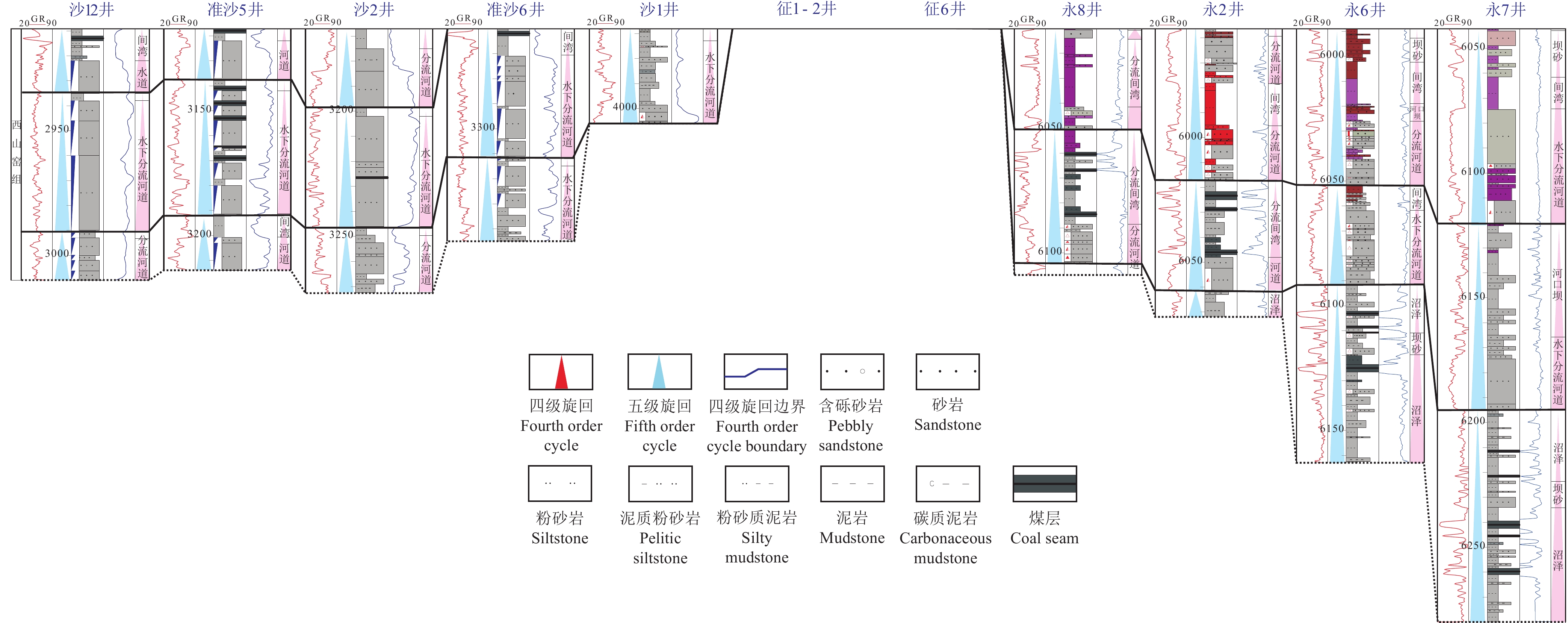
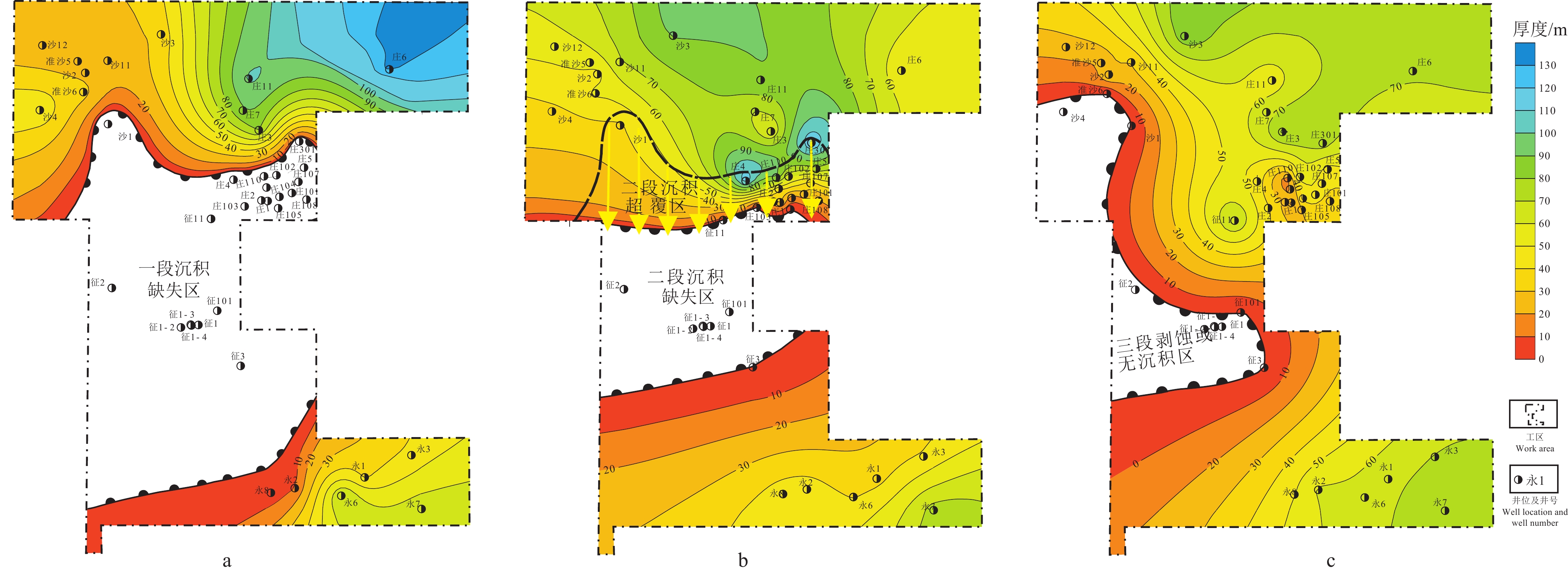
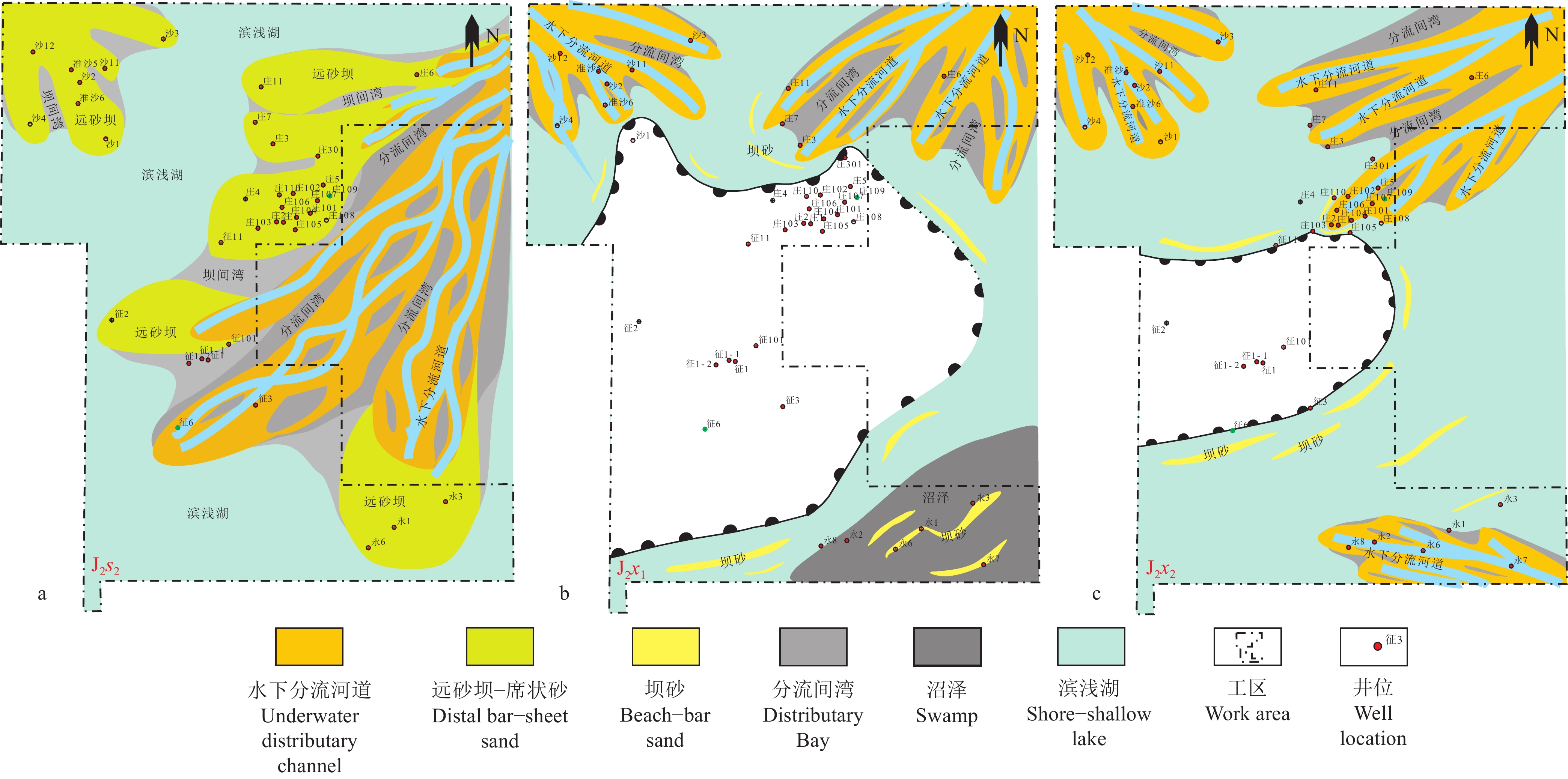
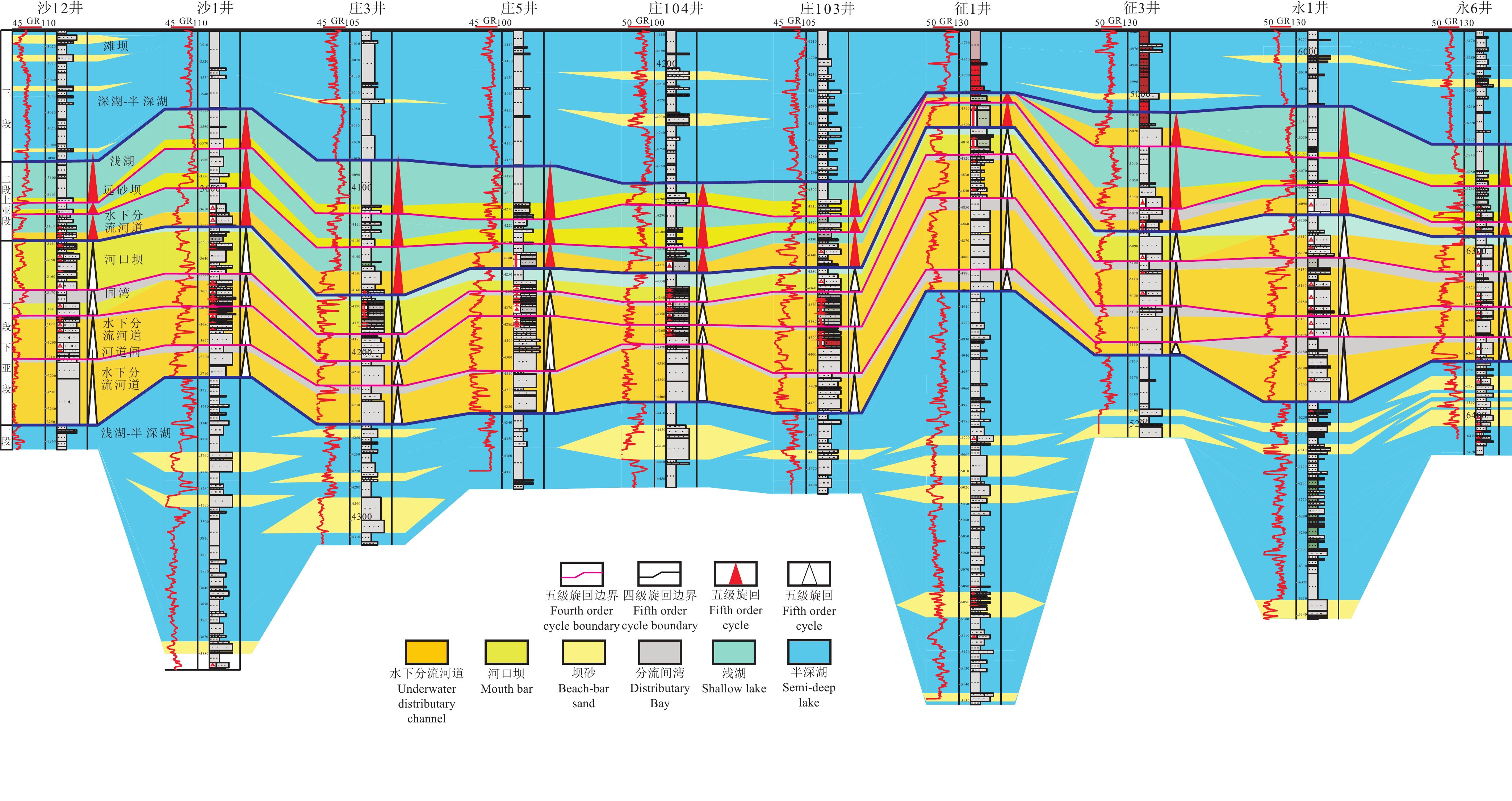
研究结果车—莫古隆起在侏罗纪的演化可划分为初始发育、快速隆升和隆升后剥蚀等三个阶段。早侏罗世车—莫古隆起的初始发育对八道湾组和三工河组展布和结构样式没有影响或影响很小,研究区由西北部扎伊尔山和东北部克拉美丽山供源,主要形成辫状河三角洲沉积体系;中侏罗世为车—莫古隆起的快速隆升阶段,除了西北部扎伊尔山和东北部克拉美丽山供源之外,博格达山也同步隆出水面开始供源,导致盆地边界、地层分布及结构样式的重大转变,使得西山窑组一段、二段大面积超覆、西山窑组三段沉积缺失或遭受剥蚀,沉积体系也随之发生转变,形成辫状河三角洲和滩坝共存的沉积体系组合;中侏罗世晚期和晚侏罗世车—莫古隆起隆升出水面则导致头屯河组和齐古组的剥蚀缺失,形成了与白垩系的区域不整合面。
结论车—莫古隆起在侏罗纪的形成和演化不仅影响到盆地的沉积地貌,也使盆地边界、物源格局发生重大改变,并导致沉积体系、地层结构样式和分布规律等的显著变化。
创新点:探讨了车—莫古隆起阶段性发育与准噶尔盆地周缘造山带,尤其是博格达山的协同演化及这种协同演化对盆地边界和沉积格局等的影响。
Abstract:This paper is the result of oil and gas exploration engineering.
ObjectiveChe−Mo synsedimentary paleouplift in Junggar basin is an important geomorphic unit that affects the structural style and reservoir distribution characteristics of Jurassic. The study of its development process is helpful to understand the basin mountain coupling relationship and the accumulation law of oil and gas reservoirs in Junggar basin.
MethodsBased on the logging data and seismic data of 41 wells in the abdomen of the basin, this paper makes a detailed analysis and isochronous comparison of Jurassic sand body and stratigraphic structure, and focuses on the synergistic evolution between the phased development of Che−Mo paleouplift and the orogenic belt around Junggar basin, especially Bogda mountain, and its influence on the basin boundary and sedimentary pattern.
ResultsThe evolution of Che−Mo paleouplift can be divided into three stages: initial development stage, rapid uplift stage and post uplift denudation stage. The initial development stage of Early Jurassic Che−Mo paleouplift has no or little influence on the distribution and structural style of Badaowan Formation and Sangonghe Formation. The study area is supplied by Zhayier mountain in the northwest and Kelameili mountain in the northeast, mainly forming braided river delta sedimentary system; The Middle Jurassic was the rapid uplift stage of Che−Mo paleouplift. In addition to the source supply of Zhayier mountain in the northwest and Kelameili mountain in the northeast, Bogda mountain also rose out of the water at the same time and began to supply the source, resulting in significant changes in basin boundary, stratigraphic distribution and structural style, resulting in large−area overlap of the first and second members of Xishanyao Formation, loss or denudation of the third members of Xishanyao Formation, The sedimentary system combination of Braided River Delta and beach bar is formed; The uplift of Che−Mo paleouplift in late Middle Jurassic and late Jurassic resulted in the denudation loss of Toutunhe Formation and Qigu Formation, forming a regional unconformity with Cretaceous.
ConclusionsThe formation and evolution of Che−Mo paleouplift in Jurassic not only affected the sedimentary landform of the basin, but also significantly changed the basin boundary and provenance pattern, and led to significant changes in sedimentary system, stratigraphic structure style and distribution law.
-
Keywords:
- Che−Mo paleouplift /
- Jurassic /
- sedimentary system /
- tectonic evolution /
- Junggar Basin
Highlights:The co-evolution of the staged development of the Che−Mo paleouplift and the orogenic belt around the Junggar Basin, especially the Bogda Mountains, and the impact of this co-evolution on the basin boundary and sedimentary pattern are discussed.
-
1. 引 言
流速、流向及悬浮沉积物浓度对海洋物理、生物、化学要素的循环具有重要影响,是研究浅海及河口地区泥沙输运、物质运移的基本要素。同步获取研究区全剖面的流速、流向及悬浮沉积物浓度对于理解悬浮沉积物输运过程、预测营养盐及污染物的迁移和归宿等问题具有重要的意义。传统的测流方法常采用单点式流速仪,对测点不同深度流速进行逐点测量以获得整个剖面的流速;悬浮沉积物浓度的测量常采用取样过滤称重法,该方法不但费时费力,而且在时间和空间的分辨率有限。
声学技术在海洋观测领域的发展应用,使得海洋水文要素的测量有了质的改变,声学多普勒剖面流速仪(Acoustic Doppler Current Profiler,ADCP),能够快速获得某个完整剖面的流速、流向等参数,同时仪器同步记录的声学背向散射强度可间接计算所测海域悬浮沉积物浓度的分布情况,为海洋泥沙动力输运的研究提供可靠的数据支撑。声学法具有不采样、水体不受扰动、精度高等特点,已被广泛应用于海洋水文要素测量中(Simpson, 2001; Yorke and Oberg, 2002; Ha and Maa, 2008; Salehi and Strom, 2011;张英豪和赖锡军, 2014; Li et al., 2019)。船载走航式ADCP是指将ADCP搭载在调查船上,结合精准的导航系统,在船只走航过程中对所测海域的海流进行连续全剖面测量,具有不扰动流场、测量历时短、测量范围大、充分利用航时等特点,已被广泛应用到江河湖海的流速、流量测量中。如1997 年三峡工程大江截流和2002 年三峡工程明渠截流(杨丰和杨俊青,2004),以及广东北江飞来峡工程截流等(刘勇胜和黄程鹏,2014),杭州湾跨海大桥、港珠澳大桥等工程也均使用ADCP 进行了流速测量(刘彦祥,2016)。
祥云岛位于乐亭县东南部,京唐港与北港之间的沿海地带,岸滩分布有优质天然细沙,是著名的沿海旅游沙岛。祥云岛外海7~15 m等深线海域建有海洋牧场,占海面积1333 hm2。近年来,祥云岛受人为活动及海洋水动力条件影响,沿岸不同区域均出现了不同程度的侵淤现象(陈文超等,2016;汪翡翠等,2021);与此同时,海洋牧场等近岸工程的建设带来的环境效应逐渐受到重视,如崔雷等(2017)通过耦合二维浅水水动力数值模型及物质输运数值模型,对京唐港填海工程中周边潮流场及悬浮沉积物运移进行模拟研究,并分析了对海域水质环境的影响。因此,对祥云岛海域流速、流向及悬浮沉积物浓度的快速同步调查,对祥云岛及其近海工程的生态环境具有重要意义。本文通过船载走航式ADCP在祥云岛海域进行现场海流、悬浮沉积物全剖面测量,为该海域海洋动力、泥沙输运及祥云岛岸线演化等海洋过程的研究提供支撑。
2. 现场调查
2.1 ADCP测流原理
ADCP基于多普勒原理(刘德铸,2010;张春海和董晓冰,2013),通过测定声波入射到海水中微颗粒背向散射在频率上的多普勒频移,从而得到不同水层水体的运动速度。所谓声学多普勒效应是指当物体相对于声源有径向位移时,导致观测到的声源发生改变的现象。多普勒频移与散射粒子速度之间的关系为:
Fd=2FVC 式中:Fd为声学多普勒频移;F为发射声波的频率;V为颗粒物沿声束方向的相对速度;C为声波在海水中的传播速度,式中“2”是因为ADCP发射并接收回波,所以多普勒频移加倍。假定水体中颗粒物的运动速度和水流速度一致,ADCP通过跟踪颗粒物的运动,测定水流相对于ADCP的速度,此速度扣除船速后,即可得到水流的绝对速度(杨锦坤等,2009)。
此外,由于散射ADCP发射波的颗粒物主要是悬浮沉积物,ADCP同步接收水中散射体的回波强度信号的大小能够间接反映水中悬浮沉积物浓度(杨惠丽等,2017)。利用ADCP背向散射强度反演悬浮沉积物含量是一种便捷,高效的方法,其非干扰式的测量特性更易获得真值。自Deines (1999)提出了声学多普勒剖面仪测得的背向散射强度与悬浮沉积物含量的关系后,许多学者也逐步开展了利用ADCP的背向散射强度反演悬浮沉积物含量的研究(Glenn et al., 1999; Hoitink, et al., 2005; Merckelbach et al., 2006; Gunawan et al., 2010)。已有研究表明源声波散射强度的大小与散射水体中的悬浮物浓度的大小成正比(Thorne and Campbell, 1992),在受潮流、潮汐作用强烈的近岸海域,利用回归公式反演的悬浮沉积物浓度与实测数据的平均误差小于20%(姬厚德等,2018)。对于有限海域,泥沙类型和粒径相对均一情况下,声学散射强度与泥沙浓度的关系可简化为公式:lg(C)=K1E+K2,其中C为悬浮沉积物浓度,E为回波强度,K1、K2为拟合因子,通过现场泥沙浓度和回波强度的回归分析来标定(Farmer, 1998)。
2.2 调查区域及测线布置
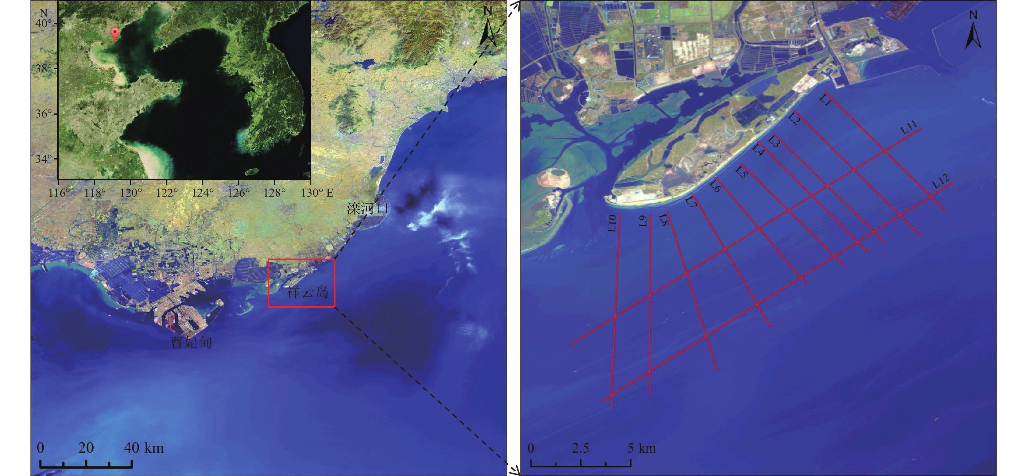
祥云岛长约13 km,呈NE-SW走向,岛屿面积20.68 km2,属于离岸沙坝岛。祥云岛东北段为潮汐通道,现已人为改造,西南端为大清河口;东部靠海侧建有简易的人工沙堤,中西部靠海侧残留低缓沙丘。潮间带的沙滩面积约为0.64 km2,潮滩平均坡度3°~8°。沉积物以浅黄色、黄棕色的细沙为主,平均粒径Mz介于2.06~2.34ϕ,分选系数介于0.24~0.47(陈文超等,2016;文明征等,2020;梅西等,2020)。
2019年7月25—28日,在祥云岛海域开展走航式ADCP测量。如图1所示本次测量共设计12条测线,其中测线L1~L10垂直于岸滩分布,平均测线长度约8.0 km;测线L11、L12平行于祥云岛分布,平均测线长度为17.5 km。由于祥云岛潮间带平缓,近岸段水深较浅,测量船容易发生触底的危险。为确保调查过程中设备和人员的安全,选择高潮位时间段进行垂直于岸线的测线测量。根据中国地质调查局天津地质调查中心在津冀沿海的潮汐站监测系统(李勇等,2020),各测线测量时间与潮位对应关系如图2所示。
2.3 参数设置
走航式ADCP测量采用美国TRDI公司生产的瑞江牌(WHR600)声学多普勒流速剖面仪,具有4个换能器,主要技术指标有:工作频率600 kHz;换能器发射角度20°测速范围为±0.01~±10 m/s(水平方向),速度分辨率0.25 cm/s;测深范围:0.75~100 m。本次调查过程中ADCP换能器入水深度为1.10 m,波束角为20°;水流层数设置为50,层厚0.50 m,第一层中心位置为1.96 m。
3. 结果与分析
祥云岛位于半封闭的渤海内部,潮汐类型属于不规则半日潮,测量期间平均潮差0.79 m。测线L1、L3、L5~L7及L10~L12测量期间为涨潮期;测线L2、L4、L8及L9测量期为落潮期(图2)。
3.1 测量结果质量控制
现场流速测量过程中受风浪等环境的干扰,测量数据会出现明显的噪点。因此,数据分析前需要将这部分数据剔除。为控制测量数据质量,本次调查将满足回波强度(Echo Intensity)为50~200 counts,相关系数(correlation)为50~200,良好百分比检验参数大于50%的数据作为有效数据,其余数据予以剔除(杨锦坤等,2009)。通常认为ADCP单次回波所测的流速误差比较大,一般使用一段时间的平均流速来表示某一点或时刻的流速,ADCP流速的平均时间可根据具体情况而定(吴云帆等,2014)。本次测量数据中参与平均的呯(ping)集合数为20(测量时船速约2.1 m/s,相当于平均时长为1 min,平均距离约50 m)。
3.2 祥云岛海域流速特征
3.2.1 海流流向特征
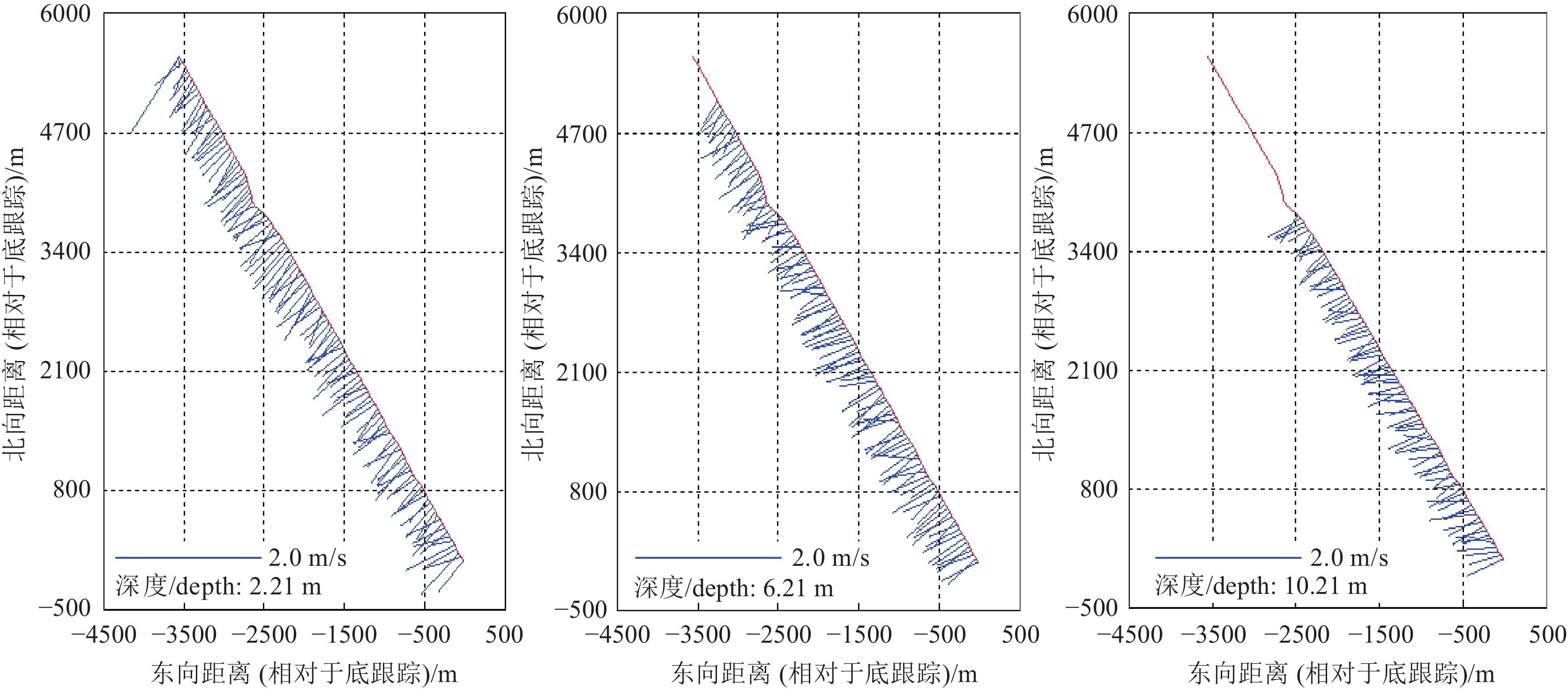
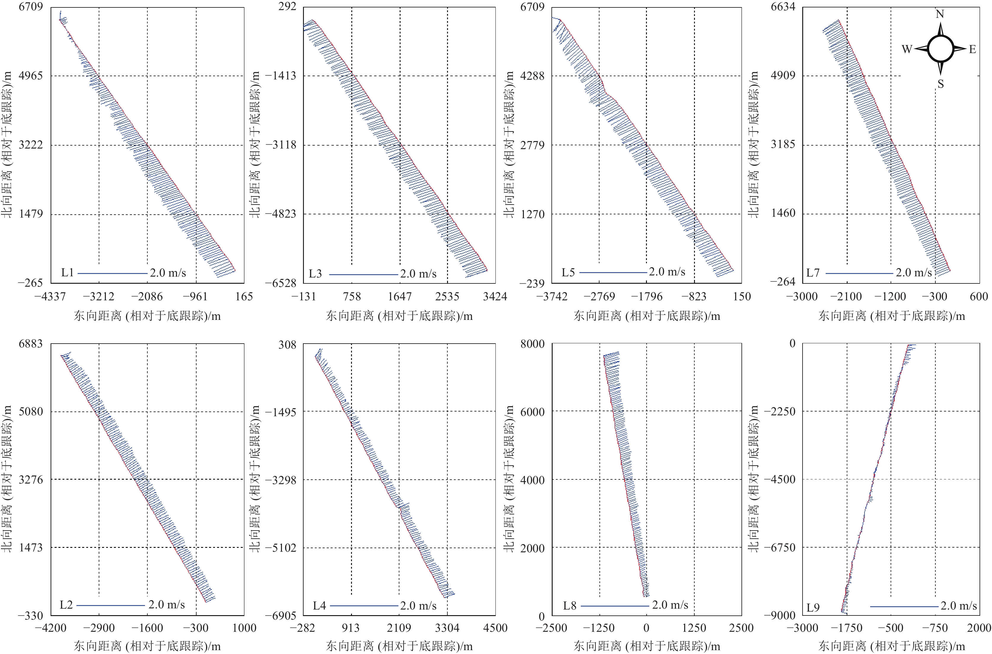
走航式ADCP获得沿测线方向的全水深流速,为更直观地显示剖面流速流向特征,本文选取表、中、底不同深度的海流进行分析。如图3所示,测线L5不同深度水层(水深2.21 m、6.21 m、10.21 m)的航迹和流速矢量图结果表明,在涨、落潮阶段海流流向在不同深度水层的流向基本保持一致。对海流流向沿深度方向求均值,如图4所示:测线L1、L3、L5和L7为涨潮期(图4a),涨潮流为SW方向;测线L2、L4和L8为落潮期(图4b),落潮流为NE方向。因此,祥云岛外海海域流向具有明显的往复特征,海流流向以NE−SW为主,基本与祥云岛岸线平行。
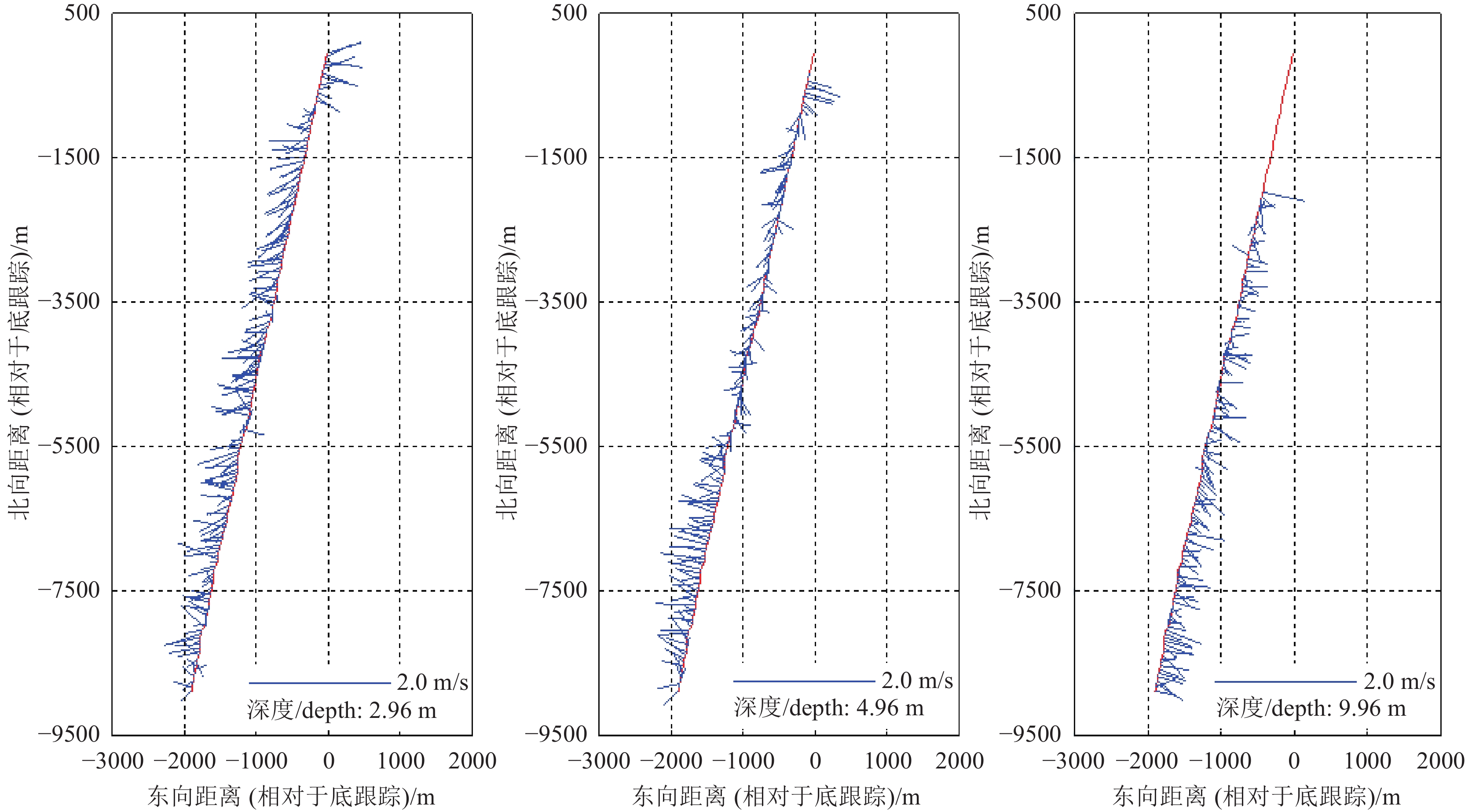
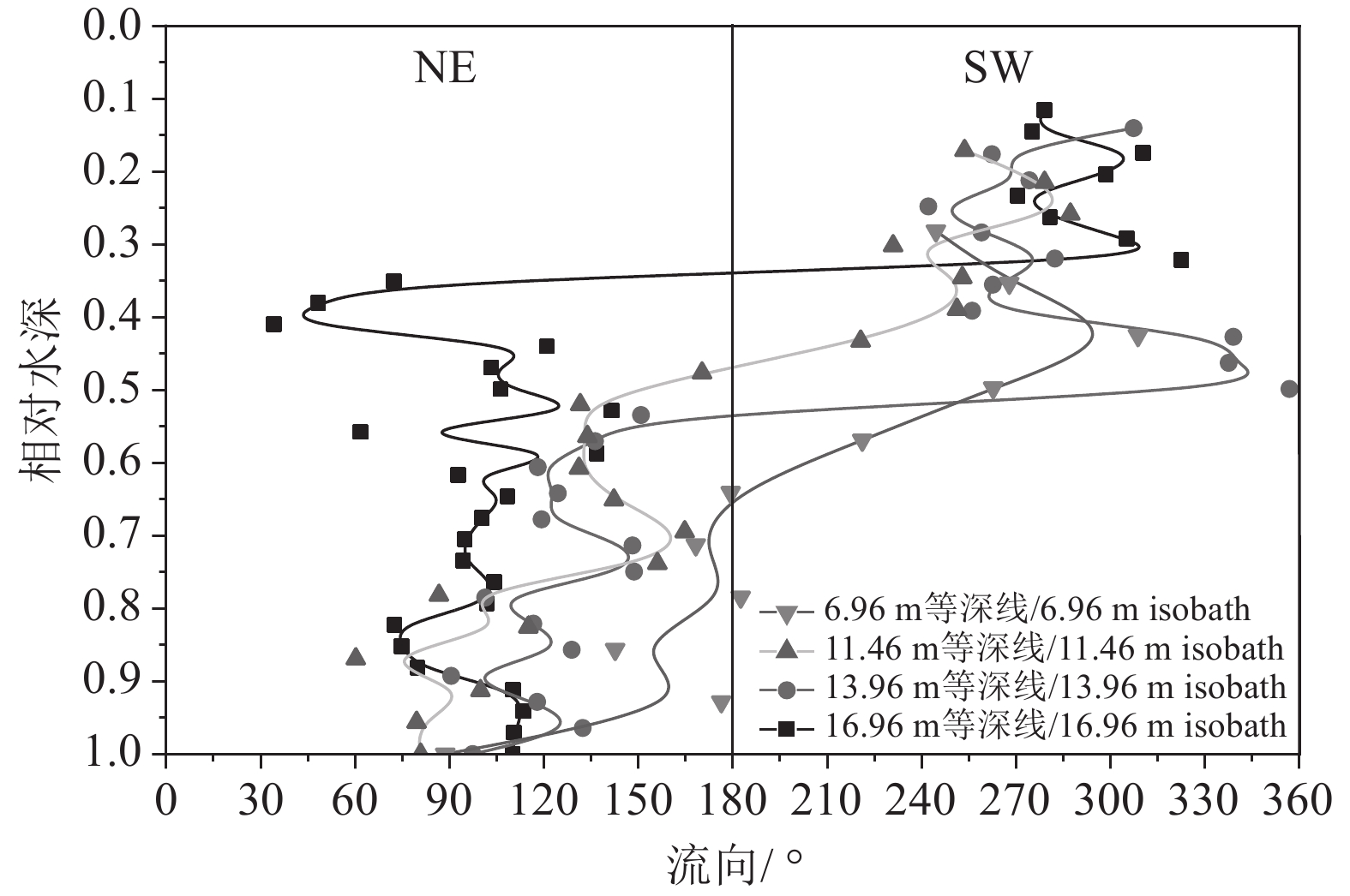
图2潮位信息显示,测线L9测量时间为平潮转落潮期,其全水深平均流向并没有表现为明显的NE方向(图4b),测线L9不同深度水层航迹和流速矢量结果如图5所示,在浅表层(2.96 m水深),近岸段流速方向为NE向,沿离岸方向流速方向为SW向,水深4.96 m水层流速矢量表明离岸段流向为SW向,水深9.96 m水层显示流速流向在整个测线上均表现为NE方向,与落潮流的方向保持一致。这表明在平潮转为落潮期间,海流转向始于底部海水,且海流转向与潮位变化具有一定的滞后性。为更清晰地描述这一问题,取测线L9不同等深线处海流流向数据绘制流向剖面分布图,如图6所示:相对水深(流速测量点水深/全水深)大于0.5时,海流流向为NE向,小于0.5是海流流向为SW向;测线L9由近岸向离岸方向测量,潮位逐渐由平潮转为落潮,沿等深线增加方向(离岸方向),流速转向的相对深度逐渐减小,再次证明该海域平潮转为落潮期间海流转向始于底层海水。
3.2.2 海流流速特征
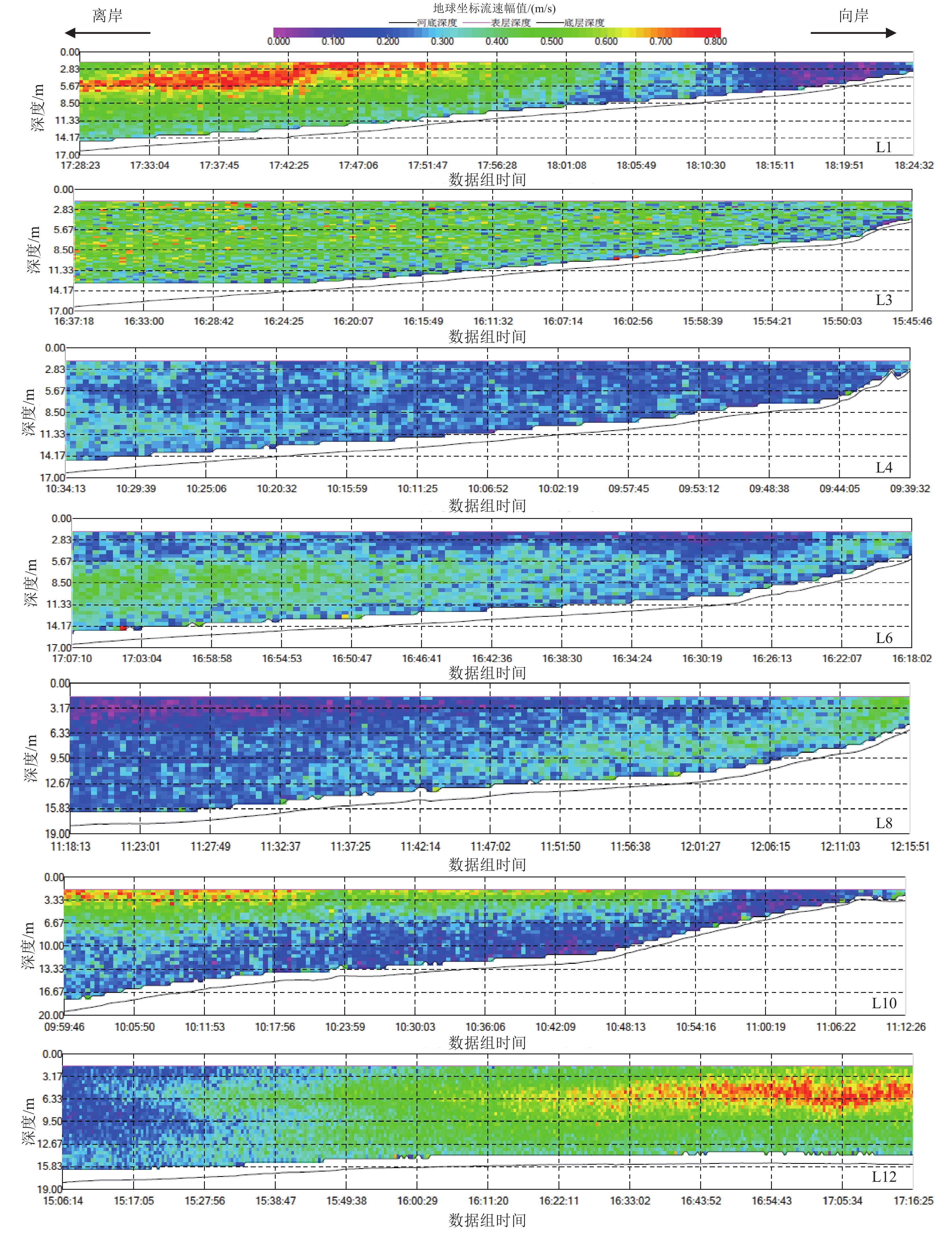
本文选取涨落潮期间典型剖面流速幅值进行对比分析,测线L1、L3、L6和L10为涨潮期、测线L4和L8为落潮期,各测线流速幅值剖面分布如图7所示。涨潮期间,测线 L1位于祥云岛东北端,离岸方向距离海底约11 m高度处有一层相对稳定的高流速层,流速可达0.7~0.8 m/s,向祥云岛滩面方向水深逐渐变浅,水深小于11 m时,该高流速层减弱;测线L10位于祥云岛西南端,其流速特征与测线L1类似,流速沿向岸方向逐渐降低;测线L3流速幅值相对均匀,垂向和向岸方向流速变化不明显;测线L6流速幅值沿向岸方向呈现明显减小的趋势。结果表明:涨潮流流速沿向岸方向逐渐减小;相对于祥云岛东北和西南段,中部流速幅值整体偏小,测线L3和L6涨潮流离岸端流速可达到0.5 m/s以上。测线L4和L8位于祥云岛中部,其流速幅值明显小于测线L3和L6,祥云岛岸段落潮流速明显低于涨潮流速,而测线L8在近岸段的流速要明显大于离岸段。
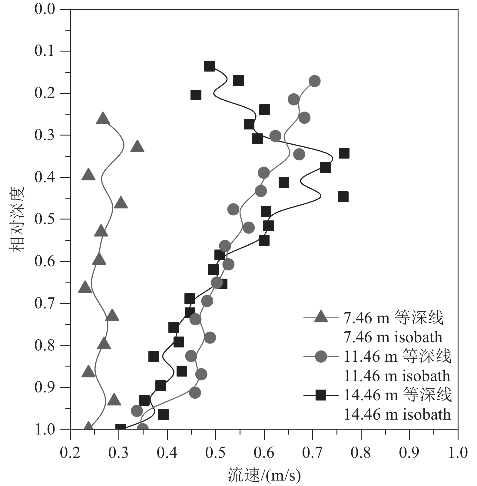
测线L11与L12均位于涨潮期,涨潮过程中测线L12在时间上更接近于L1和L10(图2)。 以测线L12为例(图7)平行于祥云岛方向,涨潮期间祥云岛东北端存在明显的高流速层,高流速层位于距离海底约11 m处,这与测线L1的测量结果是一致的。为更直观地展现高流速层的分布形态,本文以测线L1为例,取测线L1中不同等深线(14.46 m、11.46 m和7.46 m)处的流速剖面进行对比,如图8所示。离岸方向等深线测量点数值越大,14.46 m处流速剖面结构表现为抛物线型,表明该处存在明显的高流速层,向岸方向,水深减小(7.46 m),流速剖面垂向分布趋于均匀,11.46 m处为过渡段,流速剖面表现为斜直线型。
3.3 祥云岛近岸悬浮沉积物分布
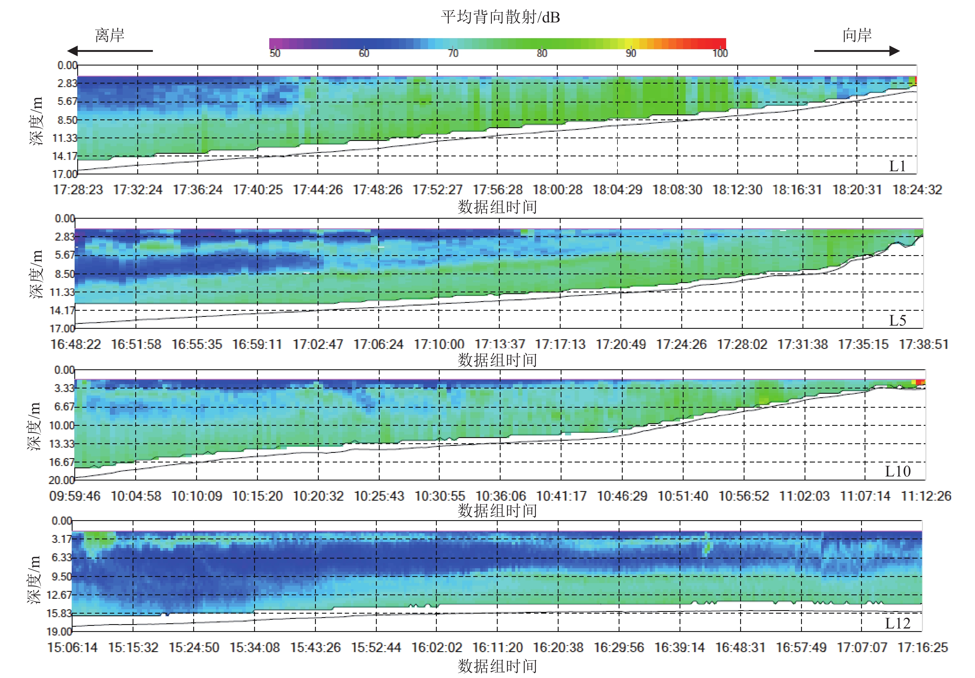
本次测量中未进行同步取样测试,未能建立背向散射强度与悬浮沉积物的回归公式。如前所述,ADCP记录的声学背向散射强度数据能够在一定程度上定性反映祥云岛周边海域的悬浮沉积物分布情况。本次测量中船载走航式ADCP记录了航测过程中的背向散射强度,以涨潮期间测线L1、L5、L10及L12为例,如图9所示。
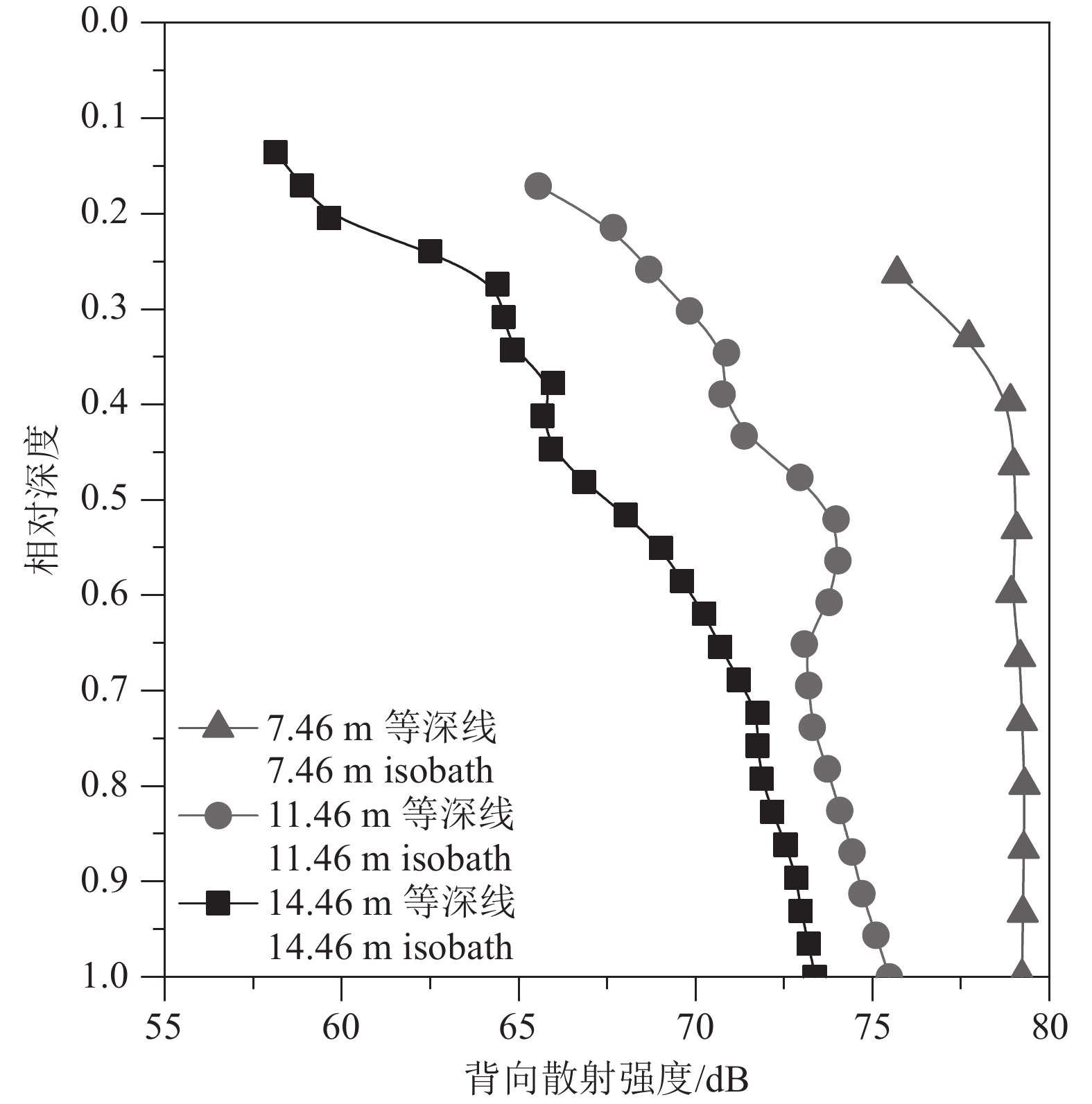
涨潮期间祥云岛不同位置背向散射强度剖面的分布结果(图9)显示,祥云岛近底普遍存在一层高悬浮沉积物层,且向岸方向悬浮沉积物浓度逐渐增加。图10为测线L1中不同等深线处(14.46 m、11.46 m和7.46 m)的背向散射强度分布对比图,更直观地反映了悬浮沉积物向岸方向增加的现象。测线L12平行于祥云岛方向,沿NE方向在近底逐渐出现一层悬浮沉积物层,高悬浮沉积物浓度层的出现与流速分布(图7,测线L12)具有很好的一致性;水体中悬浮沉积物的维持需要一定的流速,流速幅值为0.30~0.60 m/s时,水体中更容易形成一层稳定的悬浮沉积物层。沿祥云岛岸线由东北向西南方向,流速降低相应的悬浮沉积物浓度也降低,表明悬浮沉积物在向西南方向输运过程中发生沉积。
3.4 悬浮沉积物输运对岸线蚀退的影响
祥云岛是滦河早期从大清河口、长河口入海时建造的沙坝(高善明,1981),自滦河迁徙改道北移入海之后,陆源泥沙来源断绝,加之京唐港的修建,港口防沙堤不断向海延伸,截断了沿岸泥沙的补给,之后祥云岛岸线急剧退化。研究表明1987—2000年,祥云岛岸线呈现出北部侵蚀、南部淤积的状态,岸线变化速率分别为−9.20~+10.40 m/a;2000年以后,北部约1500 m砂质岸线转变为港口围堤,被京唐港扩建、祥云湾码头占用,在沿岸流作用下祥云岛东北段泥沙向西南段运移,引起西南段淤积(邢容容等,2017)。邱若峰等(2010)指出祥云岛西南端的金沙岛岸段,自1987年以来向海拓展22 m,该岸段向海推进的一个重要原因在于人为的吹沙造陆,使得该岸段泥沙补给充足(陈文超等,2016)。 本文测量结果显示祥云岛近海海域涨潮流速(SW向)大于落潮流速(NE向)且祥云岛东北端悬浮沉积物大于西南段悬浮沉积物。这表明目前祥云岛近岸海域的悬浮沉积物整体沿NE−SW方向进行运移,与目前祥云岛岸线的侵蚀现状是一致的。
此外,祥云岛海洋牧场于2007年开始申报建设,牧场位于京唐港西南的祥云湾外海海域,水深7~15 m等深线范围内。海洋牧场建设在其规划海域内投放了包括水泥沉箱、水泥铸块、花岗岩石礁、钢筋板框、船礁等在内的各类人工渔礁共计约20万m3(王湛,2018)。人工渔礁的投放必然对近岸海域的流场产生影响,天津地质调查中心2018年的模拟结果显示,人工渔礁的投放仅对投放区周围两倍面积范围内的流场有影响,并导致明显的侵蚀淤积现象
1 。但该结果尚缺乏现场实测数据支撑,有关海洋牧场建设对海域流场的影响,还需要后续海洋牧场建成后的持续跟踪调查。4. 结 论
利用走航式ADCP在祥云岛海域开展流速、流向及悬浮沉积物浓度等水文要素测量,该方法较传统的定点观测和取样测试,具有不扰动流场、测量历时短、测量范围大、充分利用航时等特点,效率大幅提升。测量结果显示:
(1)祥云岛海域海流以平行于岸线为主,具有明显的往复性,该区域涨潮流明显大于落潮流,涨潮流沿向岸方向逐渐减弱,祥云岛西南部局部落潮流存在向岸方向增强的现象。
(2)祥云岛海域在平潮向落潮过渡期间,海流转向始于底部海水,且海流转向与潮位变化具有一定的滞后性。
(3)测量期间背向散射强度数据表明,祥云岛近岸海域存在明显的高浓度层,且沿向岸方向浓度增加,平行于祥云岛岸线方向,悬浮沉积物浓度由东北向西南方向逐渐降低。
(4)祥云岛近岸海域在涨落潮流的作用下,悬浮沉积物沿祥云岛岸线由东北向西南运移,是导致祥云岛岸线在东北段侵蚀、西南段淤积的主要原因之一。
-
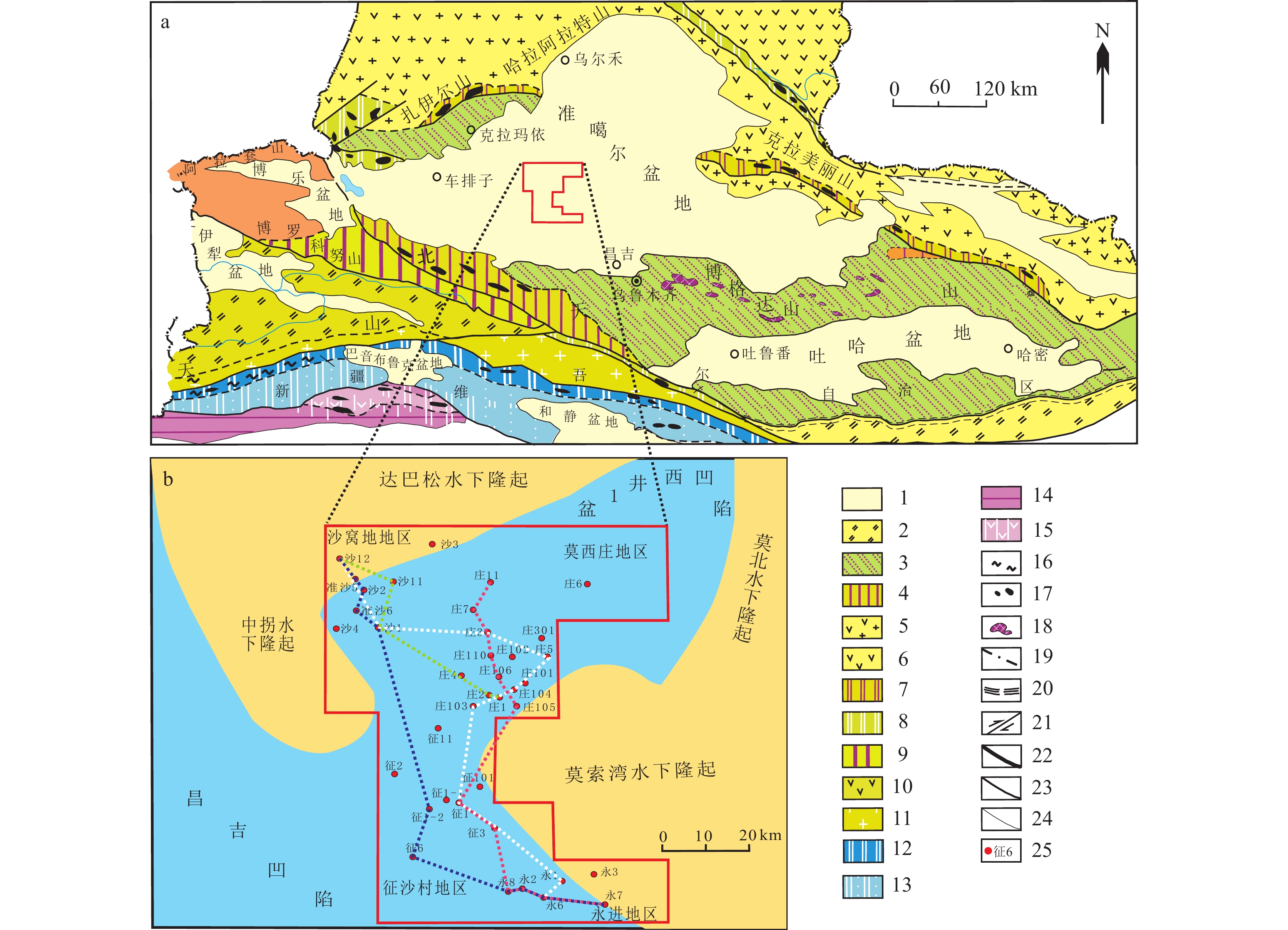
图 1 准噶尔盆地的位置及区域地质背景(a据徐学义等,2016修改)
1—中新生代盆地;2—前南华系基底上板内裂谷;3—古生代褶皱基底上板内裂谷;4—红海式裂谷;5—火山弧+岩浆弧;6—火山岛弧;7—早中泥盆世洋壳残片带;8—早古生代弧盆系及蛇绿混杂岩带;9—外陆棚沉积盆地;10—火山岛弧;11—岩浆弧;12—缝合带(蛇绿混杂岩带);13—弧前增生楔;14—上叠盆地;15—陆缘裂谷;16—高压及超高压变质岩;17—超镁铁质岩;18—辉长岩及辉长-辉绿岩;19—地球物理探测的断裂带;20—韧性断裂带;21—走滑断裂;22—缝合带边界断裂及一级构造单元边界断裂;23—二级构造单元边界断裂;24—三级构造单元边界断裂及区域性大型断裂;25—井位及井号
Figure 1. The location and regional geological background of the Junggar Basin(Fig.a modified from Xu Xueyi et al., 2016)
1−Meso−Cenozoicbasin; 2−Intraplate rift on the Prenanhua basement system; 3−Intraplate rift onPaleozoic foldedbasement; 4−Red Sea type rift; 5−Volcanic arc+Magmatic arc; 6−Volcanic island−arc; 7−Early−Middle Devonian oceanic crustal debris belt; 8−Early Paleozoic arc basin system and ophiolitic mélange belt; 9−Outer shelf sedimentary basin; 10−Volcanic island−arc; 11−Magmatic arc; 12−Suture zone (ophiolite mélange belt); 13−Forearc accretive wedge; 14−Superimposed basin; 15−Marginal rift; 16−High pressure and ultrahigh pressure metamorphic rocks; 17−Ultramafic rocks; 18−Gabbro and gabbro−diabase; 19−Geophysically detected fault zone; 20−Ductile fault zone; 21−Strike−slip fault; 22−Boundary fault of primary tectonic unit; 23−Boundary fault of secondary tectonic unit; 24−Boundary fault of tertiary tectonic unit; 25−Well location and well number
图 6 车—莫古隆起区周缘地区西山窑组各段地层厚度反映的地层缺失和超覆特征
a—西山窑组一段等厚图;b—西山窑组二段等厚图;c—西山窑组三段等厚图
Figure 6. Stratum loss and overlap characteristics reflected by the stratum thickness of each section of Xishanyao Formation in the peripheral area of Chepaizi−Mosuowan paleouplift area
a–Isopach map of the first member of Xishanyao Formation; b–Isopach map of the second member of of Xishanyao Formation; c–Isopach map of the third member of ofXishanyao Formation
图 7 研究区物源格局平面展布
a—三工河组二段沉积体系;b—西山窑组一段沉积体系;c—西山窑组二段沉积体系
Figure 7. Plane distribution of provenance pattern in the study area
a–Sedimentary system of the second member of Sangonghe Formation; b–Sedimentary system of the first member of Xishanyao Formation; c–Sedimentary system of the second member of Xishanyao Formation
-
[1] Eberth J, Pascovici G, Thomas H G, Warr N, Weißhaar D, Miniball C. 2001. From euroball to gamma−ray tracking arrays − new developments in ge detector technologies [C]//Nuclear Structure Physics − Celebrating the Career of Peter von Brentano − The International Symposium. Gottingen, Germany.
[2] Fang Shihu, Guo Zhaojie, Jia Chengzao, Zhang Zhicheng, Wang Xulong, Wang Meina. 2006. Meso−cenozoicheavy minerals’assemblages in the southern Junggar Basin and its im plications for Basin−orogen pattern[J]. Chinese Journal of Geology, 41(4): 648−662 (in Chinese with English abstract).
[3] Fang Y, Wu C, Guo Z, Kejun H, Lin D, Wang L, Li L. 2015. Provenance of the Southern Junggar Basin in the Jurassic: Evidence from detrital zircon geochronology and depositional environments[J]. Sedimentary Geology, 315: 47−63. doi: 10.1016/j.sedgeo.2014.10.014
[4] Guo Zhaojie, Zhang Zhicheng, Wu Chaodong, Fang Shihu, Zhang Rui. 2006. Mesozoic Cenozoic Tianshan uplift process and its comparative study with Junggar and Altai Mountains[J]. Acta Geologica Sinica, 80(1): 1−15 (in Chinese with English abstract). doi: 10.1111/j.1755-6724.2006.tb00788.x
[5] He Dengfa, Chen Xinfa, Kuang Jun, Zhou Lu, Tang Yong, Liu Deguang. 2008. Formation, evolution and genetic mechanism of Chepaizi Mosuo Bay paleouplift in Junggar Basin[J]. Earth Science Frontiers, 15(4): 42−55 (in Chinese with English abstract). doi: 10.1016/S1872-5791(08)60038-X
[6] He Guoqi, Lu Shuning, Li Maosong. 1995. Significance of large fault systems in paleo−plate studies: A case study of Central Asia[J]. Geological Journal of Universities, 1(1): 1−10 (in Chinese with English abstract).
[7] Ji Youliang, Zhou Yong, Kuang Jun, Wan Lu, Zhang Rui, Lu Chunhong. 2010. Formation and evolution of Che Mo ancient uplift in Junggar Basin and its control over sedimentary facies[J]. Science China Earth Science, 40(10): 1342−1355 (in Chinese).
[8] Kuang Jun, Hou Lianhua, Zhang Yueqian, Shi Xinpiao, Wang Jinghong. 2009. Shallow reservoir forming factors and exploration direction of chemogu uplift in Junggar Basin [J]. Xinjiang Petroleum Geology, 30(4): 445–449 (in Chinese with English abstract).
[9] Kuang Lichun, Lei Dewen, Tang Yong. 2013. Jurassic Cretaceous Sedimentary Characteristics and Lithostratigraphic Reservoirs in Junggar Basin [M]. Beijing: Petroleum Industry Press, 1–156 (in Chinese with English abstract).
[10] Li Zhong, Peng Shoutao. 2013. Mesozoic Cenozoic detrital zircon U−Pb chronology, provenance system analysis and intracontinental basin mountain evolution at the north and south foothills of Tianshan[J]. Acta Petrologica Sinica, 29(3): 739−755 (in Chinese with English abstract).
[11] Liu Chuanpeng. 2013. Microscopic characteristics and effective reservoir control factors of the second member of Sangonghe Formation in Moxizhuang area, Junggar Basin[J]. Geology in China, 40(5): 1515−1522 (in Chinese with English abstract).
[12] Liu Zhaorong. 2008. There is no Mesozoic paleouplift in the central Junggar Basin[J]. Xinjiang Petroleum Geology, 29(2): 256−259 (in Chinese with English abstract).
[13] Lu Cheng. 2016. Study on Secondary Logging Interpretation of Old Wells in Blocks 1 and 3 in the Central Junggar Basin [D]. Xinjiang: Xinjiang University (in Chinese with English abstract).
[14] Ma Baojun, Qi Jiafu, Yu Fusheng, Zhang Kexin. 2008, Structural characteristics and physical simulation of Che Mo ancient uplift in Junggar Basin[J]. Geotectonica et Metallogenia, 32(1): 36–41(in Chinese with English abstract).
[15] Peng B, Jin Z J, Wang H, Jia X. 2018. Sedimentology and sequence stratigraphy of a retrogradational fan−delta system within Lower Triassic in the Mabei area, Junggar Basin (northwestern China)[J]. Russian Geology and Geophysics, 59: 606−619. doi: 10.1016/j.rgg.2018.05.002
[16] Shang Xiaofei, Hou Jiagen, Cheng Yuanzhong, An Zhenyue, Yao Ruixiang, Li Yan. 2014. Discussion on the genetic mechanism of thick lake beach bar sand body and Its geological significance—Taking the second member of Shahejie Formation in Banqiao sag of Huanghua depression as an example[J]. Acta Geologica Sinica, 88(9): 1705−1718 (in Chinese with English abstract).
[17] Song Yan, Chen Shi, Zhang yilou, Liang Xinxin, Liang Yuanyuan, Hou Wen. 2020. Calibration of basin mountain differentiation time limit in the Middle and Late Jurassic in Bogda area, southeast margin of Junggar Basin[J]. ScienceTechnology and Engineering, 20(3): 924−934 (in Chinese with English abstract).
[18] Wang Jufeng, Deng Hongwen, Cai Xiyuan. 2005. Sedimentary system of Sangonghe Formation of Lower Jurassic in the hinterland of Junggar Basin[J]. Xinjiang Petroleum Geology, 26(2): 137−141 (in Chinese with English abstract).
[19] Wang Xuying, Jiang Zaixing. 2020. Sedimentary system characteristics and model of Paleogene Fusan member in Subei Basin[J]. Geoscience, 34(6): 1132−1143 (in Chinese with English abstract).
[20] Wei Hongxing. 2007. Structural Characteristics and Formation and Evolution of the Southern Margin of Bogda Mountain [D]. Shaanxi: Northwest University, 1–75 (in Chinese with English abstract).
[21] Xu Shumei, Li Meng, Wang Jinduo, Ren Xincheng, Zeng Zhiping, Wu Xiangfeng, Xu Pengcheng, Feng Huaiwei. 2020. Cycle style and sand body superposition law of Lower Jurassic Sangonghe Formation in the abdomen ofJunggar Basin[J]. Journal ofPalaeogeography, 22(2): 221−234 (in Chinese with English abstract).
[22] Xu Xueyi, Wang Hongliang, Chen Junlu. 2016. Geology of Tianshan and Its Adjacent Areas in China [M]. Beijing: Geological Publishing House, 1–175 (in Chinese with English abstract).
[23] Peng Xiling. 2007. Query on chemo ancient uplift in Junggar Basin[J]. China Petroleum Exploration, (6): 63−71 (in Chinese with English abstract).
[24] Yang Y T, Song C C, He S. 2015. Jurassic tectonostratigraphic evolution of the Junggar basin, NW China: A record of Mesozoic intraplate deformation in Central Asia[J]. Tectonics, 34(1): 86−115. doi: 10.1002/2014TC003640
[25] Yue Yong, Jiang Shu, Tian Jingchun, Lin Xin. 2024. Late Cretaceous to Early Paleocene sedimentary environment evolution: Geochemical evidences of Well PBX1 in the southwestern Tarim Basin[J]. Geology in China, 51(2): 592−605 (in Chinese with English abstract).
[26] Yu Fusheng, Amuguleng, Yang Guangda, Ma Baojun. 2008. Structural evolution characteristics and genetic simulation of Che Mo ancient uplift in Junggar Basin[J]. Acta Geoscientica Sinica, 29(1): 39−44 (in Chinese with English abstract).
[27] Zhang Fushun, Yu Yingfan, Zhu Yunhui, Xia Mouzhong. 2007. Formation and evolution of Che Mo ancient uplift and oil and gas distribution[J]. Oil and Gas Geology of Western China, 3(1): 13−20 (in Chinese with English abstract).
[28] Zhang Zhihuan, Qin liming, Li Wei, Wang Chunjiang, Qiu Nansheng, Meng Xianlong, Zhang Zhenying, Yuan Dongshan. 2009. Oil source and hydrocarbon source focus transfer of oil−bearing structures on the north and south sides of chemogu uplift in the abdomen of Junggar Basin[J]. Geology in China, 36(4): 826−836 (in Chinese with English abstract).
[29] Zhao Shujuan, Li Sanzhong, Liu Xin, Lou Da, Suo Yanhui , Dai Liming, Sun Wenjun, Li Tao, Wang Xuebin, Yang Chao. 2014. The structure of the eastern margin of Junggar Basin: The intracontinental process of the transition between Altay and North Tianshan orogenic belt[J]. Science China Earth Science, 44(10): 2130–2141 (in Chinese).
[30] Zhao Wenzhi, Jin Jiuqiang. 2000. Formation and Evolution of Jurassic Prototype Basins in Northwest China [M]. Beijing: Geological Publishing House (in Chinese with English abstract).
[31] Zhu Wen, Wang Ren, Lu Xinchuan, Shi Wanzhong, Ren Mengyi, Liu Kai. 2021. Yanshanian tectonic activity and sedimentary response in the northwest hinterland of Junggar Basin[J]. Earth Science, 46(5): 1692−1709 (in Chinese with English abstract).
[32] Zhu X M, Li S L, Wu D, Zhu S F, Dong Y L, Zhao D N, Wang X L, Zhang Q. 2017. Sedimentary characteristics of shallow−water braided delta of the Jurassic, Junggar basin, Western China[J]. Journal of Petroleum Science and Engineering, 149: 591−602. doi: 10.1016/j.petrol.2016.10.054
[33] Zhu Yunhui, Meng Xianlong. 2005. Formation and evolution of chemo ancient uplift in Junggar Basin and its influence on oil and gas accumulation in the abdomen[J]. West China Petroleum Geosciences, 1(1): 55−57 (in Chinese with English abstract).
[34] Zheng Youwei, Wang Yadong, Guo Jianming, Liu Xingwang, Zhao Guangliang, Su Long, Zheng Jianjing. 2016. Evolution characteristics of Jurassic heavy minerals in the southeast margin of Junggar Basin and its response to the uplift of Bogda mountain[J]. Acta Sedimentation Sinica, 34(6): 1147−1154 (in Chinese with English abstract).
[35] Zhao Hongliang. 2006. Evolution and reservoir control law of Che Mo paleouplift in Junggar Basin[J]. Xinjiang Petroleum Geology, 27(2): 160−162.
[36] Zhou T Q, Wu C D, Yuan B, Shi Z K, Wang J L, Zhu W, Zhou Y X, Jiang X, Zhao J Y, Wang J, Ma J. 2019. New insights into multiple provenances evolution of the Jurassic from heavy minerals characteristics in Southern Junggar Basin, NW China[J]. Petroleum Exploration and Development, 46(1): 67−81.
[37] 方世虎, 郭召杰, 贾承造, 张志诚, 王绪龙, 王美娜. 2006. 准噶尔盆地南缘中−新生界沉积物重矿物分析与盆山格局演化[J]. 地质科学, 41(4): 648−662. doi: 10.3321/j.issn:0563-5020.2006.04.008 [38] 郭召杰, 张志诚, 吴朝东, 方世虎, 张锐. 2006. 中、新生代天山隆升过程及其与准噶尔、阿尔泰山比较研究[J]. 地质学报, 80(1): 1−15. doi: 10.3321/j.issn:0001-5717.2006.01.001 [39] 何登发, 陈新发, 况军, 周路, 唐勇, 刘德光. 2008. 准噶尔盆地车排子–莫索湾古隆起的形成演化与成因机制[J]. 地学前缘, 15(4): 42−55. doi: 10.3321/j.issn:1005-2321.2008.04.006 [40] 何国琦, 陆书宁, 李茂松. 1995. 大型断裂系统在古板块研究中的意义—以中亚地区为例[J]. 高校地质学报, 1(1): 1–10. [41] 纪友亮, 周勇, 况军, 万璐, 张锐, 卢春红. 2010. 准噶尔盆地车–莫古隆起形成演化及对沉积相的控制作用[J]. 中国科学: 地球科学, 40(10): 1342−1355. [42] 况军, 侯连华, 张越迁, 石新朴, 王京红. 2009. 准噶尔盆地车莫古隆起浅层成藏因素及勘探方向[J]. 新疆石油地质, 30(4): 445−449. [43] 匡立春, 雷德文, 唐勇. 2013. 准噶尔盆地侏罗–白垩系沉积特征和岩性地层油气藏[M]. 北京: 石油工业出版社, 1–156. [44] 李忠, 彭守涛. 2013. 天山南北麓中–新生界碎屑锆石U–Pb年代学记录、物源体系分析与陆内盆山演化[J]. 岩石学报, 29(3): 739−755. [45] 刘传鹏. 2013. 准噶尔盆地莫西庄地区三工河组二段储层微观特征及有效储层控制因素[J]. 中国地质, 40(5): 1515−1522. doi: 10.3969/j.issn.1000-3657.2013.05.016 [46] 刘朝荣. 2008. 准噶尔盆地中部不存在中生代古隆起[J]. 新疆石油地质, 29(2): 256−259. [47] 路成. 2016. 准噶尔盆地中部1、3区块老井测井二次解释研究[D]. 乌鲁木齐: 新疆大学. [48] 马宝军, 漆家福, 于福生, 张克鑫. 2008. 准噶尔盆地车–莫古隆起构造特征及物理模拟[J]. 大地构造与成矿学, 32(1): 36−41. [49] 商晓飞, 侯加根, 程远忠, 安振月, 姚瑞香, 李燕. 2014. 厚层湖泊滩坝砂体成因机制探讨及地质意义—以黄骅坳陷板桥凹陷沙河街组二段为例[J]. 地质学报, 88(9): 1705−1718. [50] 宋燕, 陈石, 张艺楼, 梁鑫鑫, 梁媛媛, 侯文. 2020. 关于准噶尔盆地东南缘博格达地区中晚侏罗世盆山分异时限的标定[J]. 科学技术与工程, 20(3): 924−934. [51] 王居峰, 邓宏文, 蔡希源. 2005. 准噶尔盆地腹部下侏罗统三工河组沉积体系[J]. 新疆石油地质, 26(2): 137−141. [52] 王旭影, 姜在兴. 2020. 苏北盆地古近系阜三段沉积体系特征与模式[J]. 现代地质, 34(6): 1132−1143. [53] 魏红兴. 2007. 博格达山南缘构造特征及其形成演化[D]. 西安: 西北大学, 1–75. [54] 许淑梅, 李萌, 王金铎, 任新成, 曾治平, 武向峰, 舒鹏程, 冯怀伟. 2020. 准噶尔盆地腹部下侏罗统三工河组旋回样式及砂体叠置规律[J]. 古地理学报, 22(2): 221−234. [55] 徐学义, 王洪亮, 陈隽璐. 2016. 中国天山及邻区地质[M]. 北京: 地质出版社, 1–175. [56] 彭希龄. 2007. 准噶尔盆地车莫古隆起质疑[J]. 中国石油勘探, (6): 63–71. [57] 岳勇, 蒋恕, 田景春, 林新. 2024. 塔里木盆地西南部晚白垩世—早古新世沉积环境演化: 来自皮山PBX1井的地化证据[J]. 中国地质, 51(2): 592−605. [58] 于福生, 阿木古冷, 杨光达, 马保军. 2008. 准噶尔盆地车–莫古隆起的构造演化特征及其成因模拟[J]. 地球学报, 29(1): 39−44. [59] 张福顺, 余滢帆, 朱允辉, 夏忠谋. 2007. 车—莫古隆起形成演化与油气分布[J]. 中国西部油气地质, 3(1): 13−20. [60] 张枝焕, 秦黎明, 李伟, 王春江, 邱楠生, 孟闲龙, 张振英, 袁东山. 2009. 准噶尔盆地腹部车莫古隆起南北两侧含油构造油源及烃源灶转移[J]. 中国地质, 36(4): 826−836. [61] 赵淑娟, 李三忠, 刘鑫, 楼达, 索艳慧, 戴黎明, 孙文军, 李涛, 王学斌, 杨朝. 2014. 准噶尔盆地东缘构造: 阿尔泰与北天山造山带交接转换的陆内过程[J]. 中国科学: 地球科学, 44(10): 2130–2141. [62] 赵文智, 靳久强. 2000. 中国西北地区侏罗纪原型盆地形成与演化[M]. 北京: 地质出版社. [63] 朱文, 王任, 鲁新川, 石万忠, 任梦怡, 刘凯. 2021. 准噶尔盆地西北腹部燕山期构造活动与沉积响应[J]. 地球科学, 46(5): 1692−1709. [64] 朱允辉, 孟闲龙. 2005. 准噶尔盆地车莫古隆起的形成演化及其对腹部油气成藏的影响[J]. 中国西部油气地质, 1(1): 55−57,108. [65] 郑有伟, 王亚东, 郭建明, 刘兴旺, 赵光亮, 苏龙, 郑建京. 2016. 准噶尔盆地东南缘侏罗系重矿物演化特征及对博格达山隆升的响应[J]. 沉积学报, 34(6): 1147−1154. [66] 赵宏亮. 2006. 准噶尔盆地车莫古隆起演化及其控藏规律[J]. 新疆石油地质, 27(2): 160−162.


 下载:
下载:

