Analysis of multi-year rainfall variation and shallow groundwater flow field monitoring in Huaibei Plain
-
摘要:研究目的
变化环境下地下水时空规律的研究有助于水资源精细化管理和区域水资源安全保障。
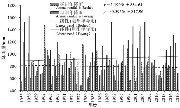
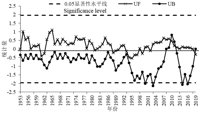
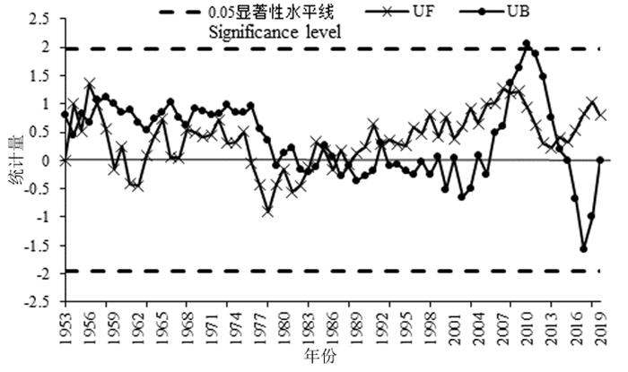
研究方法本文基于淮北平原区典型气象站1953—2019年月降雨数据,采用小波分析及M-K检验法,研究多年尺度降雨周期性变化及趋势规律;结合395个国家级监测井及地下水统测数据,采用主成分分析法进行监测井优化评价。
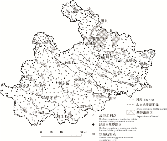
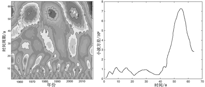
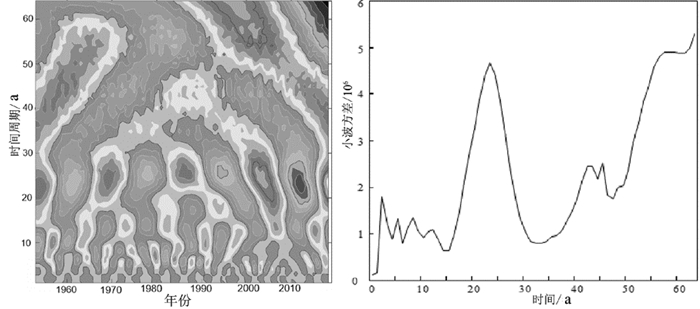
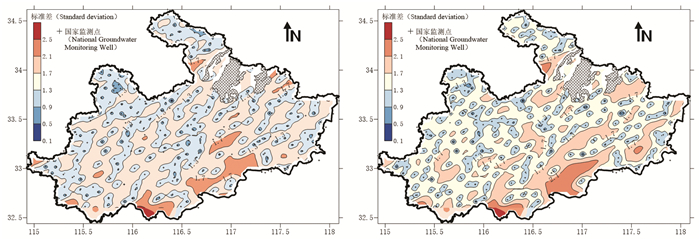
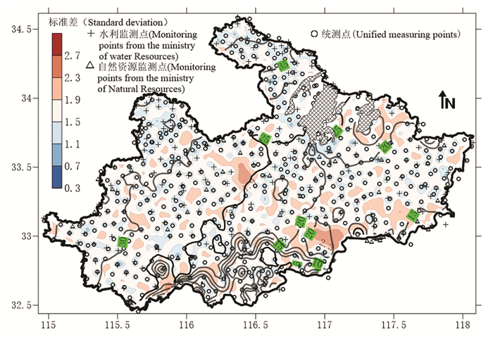
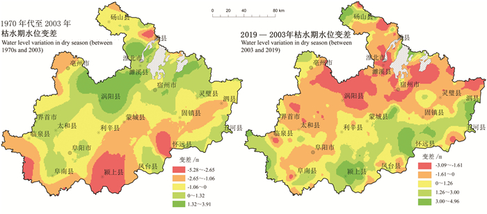
研究结果淮北平原多年降雨量呈现多时空尺度变化特征,南部地区主周期较北部地区偏小,但周期尺度较多,变化更为复杂;西北部的浅层地下水位持续下降,其余区域水位处于有升有降的波动状态;南部区域浅层地下水水位在1970年、2003年及2019年3个时段呈现出先降低再恢复,北部部分区域地下水水位则呈现先升高再降低的特征,研究区水位总体存在下降趋势,但2000年以来水位总体有所回升;经主成分分析优化后的277个监测井(221个水利井和56个自然资源井)能代表395个原国家监测井的总体水位变化情况。
结论国家地下水监测工程长序列监测数据能够很好地服务于流域尺度水资源评价及管理,但省市级尺度或重点区域还需要进行优化和加密,地下水位统测可有效填补,该工作应在重要河湖两侧、淮河北岸一带、东北部山前平原等高水力梯度区域进行加密。
创新点:(1)采用多种统计检验方法,研究淮北平原地下水流场演变特征及影响因素;(2)本文提供了一种监测网的评估和优化方法,以淮北平原为例,评估了监测-统测网的效能,并提出了优化建议。
Abstract:This paper is the result of groundwater survey engineering.
ObjectiveThe study on the temporal and spatial law of groundwater under changing environment is helpful to the fine management of water resources and the guarantee for regional water resources security.
MethodsBased on the rainfall data of typical weather stations in the Huaibei Plain from 1953 to 2019, the wavelet analysis and M-K test method was used to study the periodic changes and trend of rainfall on a multi-year scale. Combined with 395 national monitoring wells and groundwater monitoring data, the principal components analytical method was used to optimize the evaluation of monitoring wells.
ResultsThe results show that the rainfall in Huaibei Plain appears multiple temporal and spatial scales variation characteristics: The shallow groundwater level has declined continuously in the northwest, while fluctuated greatly in the other regions; In 1970, 2003 and 2019, the shallow groundwater level in the southern region decreased firstly and then recovered, and on the contrast, the shallow groundwater level in the northern region increased firstly and then decreased; The groundwater level in the study area has generally declined; And since 2000, the water level has somewhat risen; The 277 monitoring wells (221 water wells and 56 natural resource wells) optimized by principal component analysis can represent the overall water level changes of 395 original national monitoring wells.
ConclusionsThe long-term monitoring data of the national groundwater monitoring project can well serve the evaluation and management of water resources at the basin scale, but still need to be optimized and densified at the provincial, municipal scales or key areas. The artificial observation in unified time period can also make up for this deficiency which should be densified in the high hydraulic gradient areas such as both sides of important rivers and lakes, the north bank of Huaihe River, and the piedmont plain in the northeast.
-
1. 引言
水是人类生活、生产以及生态环境维系不可或缺的最基本资源(冯尚友, 2000;王浩等, 2002;卢耀如,2014)。气候变化,人口增长以及经济发展将改变未来全球水资源的形势(Vorosmarty et al., 2000;)。气候变化与社会经济发展双重因素的影响下,使得可利用水资源量成为经济稳定持续发展的主要制约因素,并使水资源除基本自然资源属性之外,进一步上升成为一种战略经济资源(Ren et al., 2016)。随着中国国民经济和社会的不断发展,城市淡水需求量不断增加,1952—2005年中国城市淡水消耗增加量是全国淡水资源量的20%(Zhu et al., 2009);中国人均水资源占有量较低, 实际人均水资源量约为1700 m3,即将步入水资源紧张国家行列(吴爱民等,2016)。水资源供需矛盾凸显,区域水资源问题严峻,水资源成为严重制约中国可持续发展的重要瓶颈(Varis and Vakkilainen, 2001;Yang et al., 2004; Zhang et al., 2008;文琦等,2008;夏军等, 2011, 2015;Guo et al., 2015;吴斌等, 2019)。
中国区域经济发展至今,取得了巨大的成就,通过“中心城市—城市群—区域发展板块”的现实,开创了区域经济的“中国模式”(陈建军和黄洁,2020)。2017年7月1日,《深化粤港澳合作推进大湾区建设框架协议》签署,协议决定将粤港澳大湾区(以下简称大湾区)建设成为更具活力的经济区、宜居宜业宜游的优质生活圈,打造国际一流湾区和世界级城市群。大湾区是中国开放程度最高、经济活力最强的区域之一,在国家发展大局中具有重要战略地位(粤港澳大湾区发展规划纲要; 覃成林等,2017)。大湾区、东京湾区、纽约湾区以及旧金山湾区并称为世界四大湾区。改革开放以来,大湾区社会经济高速发展,2018年末,总人口已达7000万,GDP总量超过10万亿元,占全国经济总量的12%。在经济高速发展的同时,长期的高强度开发带来的资源环境隐患日益凸显,如环境污染问题(张捷旋和李明,2016)、土地资源紧缺问题(曹靖和张文忠,2020);水资源问题包括:水体污染,部分城市水资源紧缺,城市内涝,河口咸潮上溯等问题(刘畅等,2019;李俊飞等,2019;高真等,2020)。
针对水资源问题,2019年2月18日,中共中央、国务院印发的《粤港澳大湾区发展规划纲要》明确指出要强化水资源安全保障。以往有针对大湾区中相关城市的水资源报道及相关研究,但由于“大湾区”概念新近提出,针对大湾区区域水资源量的分析研究较少。同时以往水资源的研究仅对现状研究以及仅限于水资源范畴探讨水资源问题,并未结合社会经济特征对水资源及其发展趋势进行研究。综上,为满足大湾区建设宜居宜业宜游的优质生活圈的发展理念,达到打造国际一流湾区和世界级城市群的发展目标以及完成强化水资源安全保障的发展规划,有必要对大湾区水资源基本情况,近年来的发展趋势以及与国际湾区的对比情况进行系统梳理与分析研究。
本文收集近10年(2010—2019年)大湾区水资源统计以及社会经济数据,旨在分析区域水资源基本特征及发展趋势同时,结合社会经济特征,对水资源现状进行归因分析并得出社会经济与水资源的协同演化规律。在此基础上选取了东京湾区的东京都会区,纽约湾区的纽约州,以及旧金山湾区的社会经济及水资源相关数据与大湾区进行对比研究。最后对大湾区未来用水结构,用水需求进行讨论分析。
2. 研究区概况
粤港澳大湾区位于广东省的腹地,面积约为5.6万km2,由广东省的广州、深圳、珠海、佛山、惠州、东莞、中山、江门、肇庆9个地级市(珠三角9市)以及香港、澳门两个特别行政区组成(图 1)。
大湾区西部及东北部海拔较高,中部西南部海拔较低,年降水量在1800~2500 mm,位于珠江流域的下游,主要过境河流为西江、北江以及东江,其次为韩江、粤东诸河、粤西桂南沿海诸河。
3. 研究内容与数据来源
本次研究主要从社会经济特征及水资源现状两个方面分析大湾区“9市+2区”的综合情况,并与国际湾区进行横向对比。社会经济特征分析主要分析各地区人口规模、人民富裕程度以及产业结构。水资源现状分析主要包括水资源分布特征以及水资源开发利用现状两方面。
本次研究数据时间跨度为2010—2019年,10个自然年。数据类型主要包括两个部分:水资源统计数据以及社会经济统计数据。其中大湾区中9市水资源数据来源于广东省水利厅的《广东省水资源公报》(http://slt.gd.gov.cn/szygb/);澳门水资源数据来源于澳门海事及水务局《水资源状况报告》,部分数据来自澳门统计普查局;香港水资源数据来源于香港特别行政区水务署《水务署年报》,部分数据来源于香港政府统计处。社会经济数据分别来自:广东统计信息网(http://stats.gd.gov.cn/),香港政府统计处(https://www.censtatd.gov.hk/hkstat/)澳门统计普查局(https://www.dsec.gov.mo/zh-MO/)。
本次研究定义了城市水资源开发利用程度来分析城市水资源供需紧张程度,根据城市供水量,考虑跨城市调水(包括对港澳供水)(即调出水量计入城市的供水量,调入水量以及深层地下水开采量不计入城市供水量),以供水总量占水资源总量的百分比体现城市水资源开发利用程度。由于内地与港澳用水类型分类不一样,对用水类型进行了简单的归并。澳门海事及水务局将用水类型分类为公共用水、工业用水、商业用水以及生活用水(澳门水资源状况报告2010/2011);而香港水务署水务年报中将用水类型分为住宅用水、工业用水、服务业及商业用水、政府用水、建筑及船舶用水以及临时淡水冲厕7类(香港水务年报2010/11)。本次统计将住宅用水作为生活用水,服务业及商业用水作为商业用水,将工业用水与建筑及船舶用水合并作为工业用水,将政府用水与临时淡水冲厕合并作为城镇公共用水。
4. 结果分析
4.1 社会经济特征
大湾区近10年(2010—2019年)各区平均人口、人均GDP如图 2所示。其中人口呈现“中部多,周边少”的现象,中部的香港、深圳、广州、东莞、佛山人口较多,而周边其他地区人口较少。人均GDP呈现“中部高,周边低”的分布特征。从表 1产业GDP贡献率可看出,香港、澳门第三产业GDP贡献率高于90%,广州、深圳、东莞第三产业GDP贡献率超过50%(表 1)。
表 1 大湾区各产业GDP贡献率(%)Table 1. Contribution of industries to GDP in the Greater Bay Area(%)
综合人口规模, 居民收入水平和第三产业的比重来看,大湾区中香港、澳门、广州以及深圳是经济发达程度较高的四大中心城市,同时也是《粤港澳大湾区发展规划纲要》指出的区域发展核心引擎。
4.2 水资源现状
4.2.1 水资源分布特征
大湾区水资源总量以及人均水资源量分布特征可以概括为“周边高,中部低”(图 3),而这与大湾区人口分布特征呈现相反的分布趋势(图 2a)
按照国际标准,人均水资源量低于3000 m3为轻度缺水,低于2000 m3为中度缺水,低于1000 m3为重度缺水,低于500 m3为极度缺水。大湾区中部地区基本处于重度缺水以及极度缺水状态,区域发展核心引擎的四大中心城市中,澳门、香港以及深圳处于极度缺水状态而广州属于重度缺水状态。
4.2.2 水资源开发利用现状
大湾区供水主要依赖于地表水,地表水供水率超过98%,中部三角洲及沿海地区的广州,佛山,东莞,深圳,中山、江门以及珠海地表水供水率更是超过99%(表 2)。香港供水主要来自两个部分:本地集水以及东江供水, 其中东江供水占70%~80%,本地集水为从集水区收集的雨水占20%~30%(水务年报2010/11,香港水务署)。澳门淡水资源主要来自西江,约有96%的原水来自珠海(澳门水资源状况报告2010/2011,澳门海事及水务局)。因此,澳门以及香港也基本依靠地表水供水。
表 2 珠三角九市供水量及供水结构Table 2. Water supply and water supply structure of nine cities in Pearl River Delta
在现有水资源分布及供水条件下,大湾区人均用水量情况呈现“中部低,四周高”的现象(图 4a)。大湾区大部分地区水资源开发利用程度较高(图 4b),其中佛山(100.25%)、中山(89.27%)、东莞(81.53%)、江门、广州(81.53%)以及深圳(43.45%)均超出国际公认的河流开发利用率警戒线(40%)(安新代,2007)。
香港、澳门及深圳的生活用水比重较高,广州、佛山、东莞及中山的工业用水比例较高,而肇庆、江门及惠州以农业用水为主(图 5a)。
同时,广州、佛山、惠州以及江门农业亩均灌溉用水量较高;在工业用水比重较高的中山、佛山以及广州,万元工业增加值用水较高(表 3)。
表 3 珠三角9市农业亩均灌溉用水量及万元工业增加值用水量(m3)Table 3. The irrigation water consumption per Mu of agriculture and the water consumption per ten thousand yuan of added industrial value in the nine cities in the Pearl River Delta(m3)
大湾区综合用水效率以万元GDP用水量来衡量,以生活用水为主的澳门、香港以及深圳用水效率高;以农业用水为主的江门、肇庆以及惠州综合用水效率较低(图 5b)。
4.2.3 水资源紧缺与供需矛盾
本次研究按照国际标准将大湾区各区缺水情况进行划分,并利用城市水资源开发利用程度来指示各区的供需紧张程度。
如图 6a所示,人均用水量随人均水资源量的增加而增加,当水资源量低于1000 m3,人均用水量随人均水资源量的增长率接近1∶1;随着人均水资源的增加人均用水量增加趋势变缓,当人均水资源量高于1000 m3时,变缓的趋势明显。如图 6b所示,水资源开发利用程度整体上随人均水资源量的增加而降低,也就是人均水资源量的增加能缓解水资源的开发利用程度,减轻水资源的供需压力。但是这种规律在人均水资源量低于1000 m3时并不明显,同时这些地区水资源开发利用程度均高于40%。也就是说在大湾区人均水资源量低于1000 m3的地区,也即香港、澳门、深圳、广州、中山、佛山、东莞都存在水资源紧缺以及供需矛盾突出的情况。
4.3 归因分析
协相关分析所选因子及结果如表 4所示,人均水资源量的现有分布情况主要受到自然因素水资源总量的控制(r2 = 0.84),其次是社会因素人口的控制(r2 = 0.27)。水资源开发利用现状的分析综合考虑人口数量,用水结构以及用水效率。其中农业用水效率和工业用水效率分别用万元工业增值用水以及农业灌溉亩均用水来指示。结果显示工业用水比重高(r2 = 0.88)、工业用水效率低(r2 = 0.26)以及人口聚集(r2 =0.15)是水资源开发利用程度高的控制因子。
表 4 水资源现状归因分析Table 4. Attribution analysis of current water resources situation
用水效率主要受到第一产业控制(r2 = 0.71),第一产业比重越高,用水效率越低。其次是第三产业(r2 = 0.45),第三产业比重越高,用水效率越高。第二产业比重也对用水效率有影响(r2 = 0.28),总体来说产业结构控制着用水效率。
4.4 整体情况与发展趋势
香港和澳门产业结构整体平稳,近10年相对变化较小,本节主要分析珠三角9市的产业结构,用水结构以及用水效率的近10年(2010—2019年)发展趋势(图 7)。在产业结构方面,珠三角9市第一产业与第二产业比重呈下降趋势,而第三产业呈上升趋势。同时,综合用水效率提高,万元GDP用水量,呈单调递减趋势,10年间下降50 m3; 工业用水效率提高,工业万元增加值用水量10年间下降近60 m3。而农业亩均灌溉用水量除2010—2011年降低之外,2011—2019年呈上升趋势,上升将近100 m3(图 7c)。在产业结构方面,用水结构以及用水效率变化下,珠三角9市用水量变化如图 7d所示。
总体上,珠三角9市近10年产业结构优化明显,用水效率整体提升,总用水量逐步下降,但城市公共用水以及生活用水量持续攀升。而相对于珠三角9市,香港和澳门产业结构和万元GDP用水量变幅较小,但在产业结构,用水效率整体上优于珠三角9市。
5. 讨论
5.1 与国际湾区对比
大湾区(粤港澳大湾区)与世界其他三大湾区(东京湾区,纽约湾区,旧金山湾区)经济、人口以及产业的横向对比如表 5所示。
表 5 国际湾区经济、人口以及产业对比Table 5. Comparison of economy, population and industry of international bay area
大湾区(粤港澳大湾区)在四大湾区中面积最大(5.6万km2),人口最多(6671万),但目前人均GDP不高,第三产业占比较低(62.2%),距离其他三大湾区80%以上的第三产业占比,还有较大发展空间。同时大湾区在四大湾区中,供水总量最大,人均用水(330.64 m3/年/人)最高(表 6)。
表 6 国际湾区水资源情况综合对比Table 6. Comprehensive comparison of water resources in the international bay area
5.2 未来发展趋势
改革开放以来,粤港澳大湾区多数城市都经历了以劳动密集型产业、高能耗产业为主要动力推进的快速发展,并逐渐进入向绿色发展转型的阶段(曹靖和张文忠,2020)。大湾区目前农业用水以及工业用水比重较高, 第三产业比重低于其他三大湾区的平均水平,人均用水量较高。产业结构理论中的“配第-克拉克定理”指出:随着经济的发展,人均国民收入水平的提高,第一产业国民收入和劳动力的相对比重逐渐下降;第二产业国民收入和劳动力的相对比重上升,经济进一步发展,第三产业国民收入和劳动力的相对比重也开始上升(魏作磊,2004)。
在2.1节社会经济特征分析以及表 5世界各大湾区横向对比中可以发现,“配第-克拉克定理”不仅可以从一个国家或地区经济发展的时间序列分析中得到印证,而且还可以从处于不同发展水平国家和地区在同一时点上的横向对比中得到类似的验证。据美国地质调查局报告,1957年旧金山人口为256万,年需水量8.76亿m3,人均年需水量为342.19 m3, 其中农业灌溉占总用水量的40% (Howard et al., 1957);而至2015年,人口上涨至733.17万,年需水量18.2亿m3,人均需水量为215.09 m3,农业灌溉占总用水量的10% (ANNUAL SURVEY 2018-2019)。旧金山湾区人均用水量的下降与产业结构优化,用水效率提升有关。同时,从4.4节的趋势分析中可以看出,大湾区的珠三角9市国民经济水平在提高,第三产业比重持续增长向更高的经济水平发展。未来大湾区将发展为经济水平更高,第三产业比重更高,产业结构更优良的世界级湾区。随着产业结构的优化及工业用水效率的下降,人均用水量会逐步下降;同时城市公共用水以及生活用水需求量及比重将持续攀升,城市淡水需求量的持续攀升,将导致大湾区对供水设施、供水水质、供水量以及供水安全的要求上升。
6. 结论
综上,本次研究得出以下几点结论:
(1)目前大湾区水资源区域分布不均且供水结构单一,与区域经济发展不协调。澳门、香港、深圳、东莞、广州、中山以及佛山,水资源供需紧张。国民经济较为发达的佛山、中山、广州(>80%)以及深圳(>40%)水资源开发程度高。
(2)大湾区的社会经济特征与水资源开发利用现状有协同关系:产业结构影响大湾区的用水结构以及水资源开发利用程度,控制用水效率。其中工业用水量比重越大,水资源开发利用程度越高。第三产业的比重越高,万元GDP用水量越小,用水效率越高。
(3)大湾区人均用水量在世界四大湾区最高,这与其目前产业结构中第一产业与第二产业占比较高,而第三产业占比(60%)较低有关。
(4)近10年珠三角九市产业结构优化明显,农业用水量与工业用水量呈下降趋势,但城市公共用水量以及生活用水量持续攀升,需要确保供水设施、供水水质以及供水安全满足大湾区未来社会经济发展需求。
-
表 1 水利监测井主成分分析结果统计(m)
Table 1 The principal component analysis results of monitoring wells from Water Sector(m)

表 2 自然资源监测井主成分分析结果统计(m)
Table 2 The principal component analysis results of monitoring wells from Natural resources department(m)

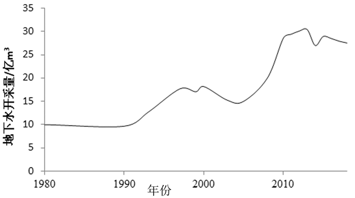
表 3 2018年淮北平原主要地(市)地下水开采量
Table 3 Groundwater exploitation in major cities of Huaibei Plain in 2018

-
Ahmadian M, Chavoshian M. 2012. Spatial variability zonation of groundwater-table by use geo-statistical methods in central region of Hamadan province[J]. Journal of Annals of Biological Research, 3(11): 5304-5312.
Ahmed Waqas, Zulfiqar Ali Rahimoon, Carlos Anthony Oroza, Salman Sarwar, Abdul Latif Qureshi, Jehangir Framroze Punthakey, Muhammad Arfan. 2020. Modelling groundwater hydraulics to design a groundwater level monitoring network for sustainable management of fresh groundwater Lensin Lower Indus Basin, Pakistan[J]. Applied Sciences, 10(15): 5200. https://doi.org/10.3390/app10155200
Chen X, Hao Z C, Dai M L. 2016. Danimic analysis of shallow groundwater in Huaibei Plain[J]. Journal of Anhui Agriculture Science, 44(28): 73-76(in Chinese with English abstract).
Chen Xiao. 2019. Study on Evolution and Prediction of Groundwater Depth in Huaibei Plain of Anhui Province[D]. Hefei: Anhui Agricultural University (in Chinese with English abstract).
Cui Linfeng, Yang Xue, Chen Bangsong, Li Haitao. 2019. Optimum design of regional groundwater level monitoring networks in Wuhan[J]. Ground Water, 41(4): 33-36(in Chinese with English abstract).
Gocic M, Trajkovic S. 2013. Analysis of changes in meteorological variables using Mann-Kendall and Sen's slope estimator statistical tests in Serbia[J]. Global & Planetary Change, 100(1): 172-182.
Gong Jianshi, Wang Hesheng, Li Liang, Zhou Kai'e, Ye Yonghong, Zhu Chunfang, Xu Naizhen, Tao Xiaohu, Tan Mengjiao, Shu Longcang, Zhao Guizhang. 2021. Groundwater resources and development potential in Huaihe River Basin[J]. Geology in China, 48(4): 1052-1061(in Chinese with English abstract).
Guo Wenxian, Li Yue, Zhang Ling, Zhao Rongsheng, Wang Hongxiang. 2019. Analysis of annual runoff and sediment variation and driving factors at Yichang Station in Yangtze River over 60 years[J]. Journal of China Hydrology, 39(6): 69-73(in Chinese with English abstract).
Janardhanan Sreekanth, Dan Gladish, Dennis Gonzalez, Dan Pagendam, Trevor Pickett, Tao Cui. 2020. Optimal design and prediction-independent verification of groundwater monitoring network[J]. Water, 12(1): 123. https://doi.org/10.3390/w12010123
Jiang Yuehua, Lin Liangjun, Chen Lide, Ni Huayong, Ge Weiya, Cheng Hangxin, Zhai Gangyi, Wang Guiling, Ban Yizhong, Li Yuan, Lei Mingtang, Tan Chengxuan, Su Jingwen, Zhou Quanping, Zhang Taili, Li Yun, Liu Hongying, Peng Ke, Wang Hanmei. 2017. Research on conditions of resources and environment and major geological problems in the Yangtze River Economic Zone[J]. Geology in China, 44(6): 1045-1061. (in Chinese with English abstract).
Júnez-Ferreira H E, Herrera G S, Saucedo E, Pacheco-Guerrero A, 2019. A. Pacheco-Guerrero. Influence of available data on the geostatistical-based design of optimal spatiotemporal groundwater-level-monitoring networks[J]. Hydrogeology Journal, 27: 1207-1227. doi: 10.1007/s10040-018-01921-w
Lei Kunchao, Luo Yong, Chen Beibei, Guo Gaoxuan, Jia Sanman, Tian Fang, Zhou Yi. 2016. Optimization design of land subsidence levelling network of Beijing Plain[J]. Geology in China, 43(4): 1457-1467(in Chinese with English abstract).
Liu Zhizheng, Wu Xiaodong, Lin Hongxiao. 2010. Kriging interpolation model and its application in optimization of groundwater level monitoring network[J]. Yangtae River, 41(9): 14-17(in Chinese with English abstract).
Machiwal Deepesh, Mishra Amit, Jha Madan K, Sharma Arun, Sisodia S S. 2012. Modeling short-term spatial and temporal variability of groundwater level using geostatistics and GIS[J]. Journal of Natural Resource Research, 21(1): 117-136. doi: 10.1007/s11053-011-9167-8
Song Ge, Huang Jinting, Ning Bohan, Wang Jiawei, Zeng Lei. 2021. Effects of groundwater level on vegetation in the arid area of western China[J]. China Geology, 4(3): 527-535.
Sun Fangqiang, Yin Lihe, Jia Wuhui, Zhang Jun, Wang Xiaoyong, Zhu Lifeng, Zhang Xinxin, Tang Xiaoping, Dong Jiaqiu. 2020. Soil water movement and deep drainage through thick vadose zones on the northern slope of the Tianshan Mountain: Croplands vs. natural lands[J]. China Geology, 3(1): 113-123. doi: 10.31035/cg2020008
Wang Faxin, Bai Ju. 2014. Distribution characteristics of shallow groundwater depth in huaibei plain[J]. Ground Water, 36(5): 51-53(in Chinese with English abstract).
Wang Guiling, Zhang Wei, Ma Feng, Lin Wenjing, Liang Jiyun, Zhu Xi. 2018. Overview on hydrothermal and hot dry rock researches in China[J]. China Geology, 1(2): 273-285. doi: 10.31035/cg2018021
Wang Haojie, Zuo Qiting, Luo ZengLiang. 2017. Runoff evolution characteristics of a typical station in Shayinghe River basin and attribution analysis[J]. South to North Water Transfers and Water Science & Tenchnology, 15(5): 36-42(in Chinese with English abstract).
Yao Rui, Sun Peng, Zhang Qiang, Jiang Shangming, Xia Min, Wang Hongjun. 2020. Spatiotemporal patterns of the shallow groundwater depth across the Huaibei Plain[J]. Acta Scientiarum Naturalium Universitatis Sunyatseni, 59(2): 110-119(in Chinese with English abstract).
陈玺, 郝振纯, 戴明龙. 2016. 淮北平原浅层地下水动态研究[J]. 安徽农业科学, 44(28): 73-76. https://www.cnki.com.cn/Article/CJFDTOTAL-AHNY201628024.htm 陈笑. 2019. 安徽省淮北平原地下水位埋深演变及预测研究[D]. 合肥: 安徽农业大学. 崔霖峰, 杨雪, 陈邦松, 李海涛. 2019. 武汉市区域地下水位监测网优化研究[J]. 地下水, 44(4): 33-36. https://www.cnki.com.cn/Article/CJFDTOTAL-DXSU201904012.htm 龚建师, 王赫生, 李亮, 周锴锷, 叶永红, 朱春芳, 徐乃政, 陶小虎, 檀梦皎, 束龙仓, 赵贵章. 2021. 淮河流域地下水资源概况及开发潜力[J]. 中国地质, 48(4): 1052-1061. http://geochina.cgs.gov.cn/geochina/article/abstract/20210405?st=search 郭文献, 李越, 张陵, 赵荣生, 王鸿翔. 2019. 近60年长江中游宜昌站水沙变化与驱动因素分析[J]. 水文, 39(6): 69-73, 58. https://www.cnki.com.cn/Article/CJFDTOTAL-SWZZ201906012.htm 姜月华, 林良俊, 陈立德, 倪化勇, 葛伟亚, 成杭新, 翟刚毅, 王贵玲, 班宜忠, 李媛, 雷明堂, 谭成轩, 苏晶文, 周权平, 张泰丽, 李云, 刘红樱, 彭柯, 王寒梅. 2017. 长江经济带资源环境条件与重大地质问题[J]. 中国地质, 44(6): 1045-1061. http://geochina.cgs.gov.cn/geochina/article/abstract/20170601?st=search 雷坤超, 罗勇, 陈蓓蓓, 郭高轩, 贾三满, 田芳, 周毅. 2016. 北京平原区地面沉降水准监测网点位优化[J]. 中国地质, 43(4): 1457-1467. http://geochina.cgs.gov.cn/geochina/article/abstract/20160429?st=search 刘治政, 吴晓东, 林洪孝. 2010. Kriging插值模型在地下水位监测网优化中的应用[J]. 人民长江, 41(9): 14-17. https://www.cnki.com.cn/Article/CJFDTOTAL-RIVE201009005.htm 王发信, 柏菊. 2014. 淮北平原浅层地下水位埋深区域分布特点[J]. 地下水, 36(5): 51-53. 王豪杰, 左其亭, 罗增良. 2017. 沙颍河代表站径流演变特征及归因分析[J]. 南水北调与水利科技, 15(5): 36-42. https://www.cnki.com.cn/Article/CJFDTOTAL-NSBD201705006.htm 姚蕊, 孙鹏, 张强, 蒋尚明, 夏敏, 汪军红. 2020. 淮北平原区浅层地下水埋深时空分布特征[J]. 中山大学学报(自然科学版), 59(2): 110-119. https://www.cnki.com.cn/Article/CJFDTOTAL-ZSDZ202002013.htm -
期刊类型引用(14)
1. 谭双,刘晓东,雷勇亮,陈琪,万建军,吴昆明,欧阳平宁,黄宏业. 桂北苗儿山铀矿田铀源分析:来自周缘红盆碎屑锆石的制约. 大地构造与成矿学. 2025(01): 70-89 .  百度学术
百度学术
2. 王珂,吴昆明,朱煜翔,欧阳平宁,黄宏业,范鹏飞,陈琪,谭双,谷勇. 桂东北苗儿山地区上小地加里东期花岗斑岩成因及其与铀成矿关系. 大地构造与成矿学. 2024(03): 580-598 .  百度学术
百度学术
3. XUE Wenhao,LIANG Yayun,LI Xiaofeng,LI Mingyi,XIE Wenbo,PENG Xue,XIA Rui,HE Hongsheng,XIAO Jincheng. The Geology, Fluid Inclusions, and O-S Isotopes of the Mibei Gold Deposit, Hunan Province, Southern China. Acta Geologica Sinica(English Edition). 2024(04): 992-1006 .  必应学术
必应学术
4. 赵子翔,陈琪,王凯兴,孙立强,刘晓东,杨建俊,谭双. 桂北沙子江铀矿床赤铁矿地球化学特征及铀成矿启示. 铀矿地质. 2024(06): 1100-1117 .  百度学术
百度学术
5. 陈剑锋,杜云,熊伊曲,管申进,何红生,周立同,陆文,石金江. 南岭加里东期钨锡矿床成矿机制研究:以湘西南落家冲矿床为例. 岩石学报. 2023(06): 1693-1716 .  百度学术
百度学术
6. 李科甫,朱传庆. 华夏地块花岗岩生热率特征及其对地温场的影响. 石油科学通报. 2023(03): 259-289 .  百度学术
百度学术
7. 李根,方贵聪,冯佐海,黄振男,罗桥花,黄祥林,蒋松林. 桂东北胡家田萤石矿床稀土元素地球化学特征及其指示意义. 桂林理工大学学报. 2023(01): 52-60 .  百度学术
百度学术
8. 贺海洋,王亭亭,唐振平,任烜,侯淡平,香承希,刘毅,黄智. 湖南加里东期花岗岩成因及铀成矿关系. 南华大学学报(自然科学版). 2023(02): 45-53 .  百度学术
百度学术
9. 杜云,田磊,郑正福,陈剑锋,张小强,王敬元,周立同,樊晖,李超. 湘西南落家冲钨锡矿床加里东期成岩成矿年龄的测定:对华南多旋回构造-岩浆活动与成矿作用的启示. 地质通报. 2022(05): 886-902 .  百度学术
百度学术
10. 于玉帅,周云,牛志军,安志辉,刘阿睢. 湖南彭公庙岩体地球化学特征、时代及钨锡成矿潜力. 岩石矿物学杂志. 2022(04): 695-713 .  百度学术
百度学术
11. 田磊,杜云,邹源,刘邦定,张小强,樊晖. 湘西南苗儿山地区水系沉积物地球化学特征及找矿方向. 华南地质. 2021(02): 164-176 .  百度学术
百度学术
12. 李胜苗,田磊,杜云,邹源,樊晖,章靖. 南岭苗儿山地区沙坪岩体型白钨矿床地质特征及找矿意义. 国土资源导刊. 2021(03): 60-65 .  百度学术
百度学术
13. 张山,巫建华,刘帅,杨东光,马树松,祝东. 赣南古家营盆地英安岩时代、成因及对早古生代构造演化的制约. 地质通报. 2021(09): 1459-1475 .  百度学术
百度学术
14. 王珂,陈琪,吴昆明,黄宏业,谢飞,张宇. 桂东北苗儿山地区花岗岩型铀矿田地质特征及成矿模式分析. 东华理工大学学报(自然科学版). 2021(06): 540-552 .  百度学术
百度学术
其他类型引用(5)


 下载:
下载:


