Evolution of groundwater level in the North China Plain in the past 40 years and suggestions on its overexploitation treatment
-
摘要:
华北平原是中国三大平原之一,同时也是粮食主产区之一,京津冀协同发展区,雄安新区皆位于区内,地理位置极其重要。地下水是华北平原主要的供水水源,占总供水量70%左右,自20世纪70年代末以来地下水开采强度不断增大,长期处于严重超采状态,形成规模巨大地下水位降落漏斗,进而引发地面沉降、地裂缝、湿地退化、海水入侵等一系列环境地质问题,制约社会经济可持续发展。研究地下水位演变可以为地下水超采治理及降落漏斗修复提供支撑,本文基于华北平原2019—2020年高密度地下水位统测数据及历史水位资料,研究了2020年现状地下水位流场及漏斗分布状况,系统分析了近40年来地下水位变化特征。研究发现:华北平原东西部浅层地下水位呈现差异化发展,20世纪80年代至2014年平原西部浅层地下水位持续快速下降,累计降幅达20~60 m,太行山前冲洪积扇缘一带水位降幅最大,2014年南水北调工程供水后,西部山前主要城市水位止跌回升;中东部地区水位呈现自然波动状态。深层地下水位20世纪80年代至2014年,总体呈下降趋势,中东部地区水位降幅度最大,累计达到40~90 m;2014年后城市区与农业区深层地下水位呈差异化发展,城区水位回升明显,周边农业区仍呈快速下降趋势。此外,在地下水演变分析基础上,以地下水采补平衡及水位恢复为目标,提出了开展超采区防控目标水位阈值研究、制定地下水减采和回补精准治理方案、优化地下水位监测网以及南水北调农业水源置换可行性研究等建议。研究成果对支撑华北平原地下水超采精准治理,地下水位降落漏斗修复和地下水资源合理开发与管理都具有重要意义。
Abstract:As one of the three great plains in China, North China Plain is also one of the main grain-producing areas. As Beijing-Tianjin-Hebei coordinated development zone and the Xiongan New Area are both located in the region, its geographical location is extremely important. Groundwater is the main source of water supply in North China Plain, accounting for about 70% of the total water supply. The increasing exploitation of groundwater since the end of 1970s enables it to be in a state of serious overexploitation for a long time, forming a huge groundwater depression cone leading to a series of environmental and geological problems such as land subsidence, ground cracks, wetland degradation, seawater intrusion, etc., restricting the sustainable development of society and economy. The analysis and research on the evolution of groundwater level can provide support for the treatment of groundwater overrun and the restoration of falling funnels. Based on the high-density simultaneous measurement of groundwater level from 2019 to 2020 and historical groundwater level data, the flow field and funnel distribution of the current groundwater level in 2020 were clarified, and the variation characteristics of the groundwater level in the last 40 years were systematically analyzed. The results show that the shallow groundwater in the eastern and western parts of the North China Plain develops in different ways, the shallow groundwater in the west of the plain continued to decline rapidly from the 1980s to 2014 with a cumulative decline of 20-60 meters. The water level in the edge of alluvial and diluvial fan in the piedmont of Taihang Mountain declined the most. After the South-to-North Water Transfer Project began supplying water in 2014, water levels in major western piedmont cities stopped falling and rose. The groundwater level in the central and eastern regions fluctuated naturally. From the 1980s to 2014, the deep groundwater level showed a general downward trend, and the water level in the central and eastern regions dropped the most, reaching 40-90 m accumulatively. After 2014, the deep groundwater level in urban areas and agricultural areas developed differently, and the water level in urban areas recovered obviously, while the surrounding agricultural areas still showed a rapid downward trend. Additionally, based on the analysis of groundwater evolution, aiming at the balance of groundwater mining and recharge and water level recovery, some suggestions are put forward to carry out the research on the threshold of target water level for the prevention and control of overexploitation areas, formulate the groundwater abatement and recharge scheme, and optimize the groundwater level monitoring network. The research results are of great significance to support the accurate management of groundwater overexploitation in the North China Plain, the restoration of groundwater depression cone, and the rational development and management of groundwater resources.
-
1. 引言
华北平原是中国人口最密集、经济最发达的地区之一,是重要的粮食生产基地,但同时又是水资源最为短缺的地区之一(邵景力等, 2009;吴爱民等, 2010;李文鹏等, 2020)。自20世纪70年代末以来,地下水开采强度不断增大,地下水位持续下降并形成巨大的地下水降落漏斗(王晓光等, 2019),同时引起了地面沉降、湿地退化、海水入侵等一系列的环境地质问题,成为制约该地区可持续发展的瓶颈(张光辉等, 2004;石建省等, 2014;朱菊艳等, 2014)。近年来为了解决华北地下水超采问题,国家与地方实施了地下水减采、南水北调补水等一系列措施,并取得了积极成效(李文鹏等, 2020;Zhu, 2020)。基于地下水在华北平原的重要战略地位,地下水位变化特征及地下水超采治理对策研究一直受到学者的持续关注,取得了一系列瞩目的研究成果。
地下水位演变研究方面,张宗祜等(1997a, b)认为20世纪50年代以来,人类活动导致华北平原水动力场发生明显变化,使得补给量减少,咸水可能下移(Liu, 2001)。费宇红等(2009)和卫磊等(2019)研究也表明,华北平原区自20世纪60年代以来地下水位下降的主要动因为人类活动,农业灌溉开采地下水是其中重要的因素之一(胡春胜等, 2002;Xu et al., 2005;张光辉等, 2013);石建省等(2010)和钱永等(2014)分析华北平原多年水位变化状况,对比地下水资源量与开采量,认为华北平原地下水已无开采潜力,亟需开展相关措施解决华北水位危机。在地下水超采治理对策方面,相关专家及学者提出了针对性建议,例如谢新民等(2007)提出对华北地下水位划出蓝线与红线,以此来为地下水位的控制提供依据。邵景力等(2009)(Shao et al., 2013)通过模拟等手段分析地下水对环境的控制作用,确定了华北地区地下水水位恢复阈值,并预测南水北调工程会对水位恢复起到重要作用(崔亚莉等, 2009;赵辉等, 2010;Zhang, 2018)。王贵玲等(2007)则提出可在山前冲洪积扇区实施地下水回灌工程以缓解华北地下水超采问题(许广明等, 2009;张兆吉等, 2009b)。张光辉等(2011)则认为优化调整产业结构,大力发展节水技术同样起到重大作用(Zhang, 2003;Yu et al., 2020;Yuan, 2021),通过轮耕、休耕等调节种植方式技术可以有效减少地下水使用(Wu, 2019;Sun, 2019; Liu, 2020)。
华北平原作为全国研究程度最高地区之一,地下水位演变及超采治理对策研究成果丰硕。但是近年来,随着地下水超采治理持续推进、南水北调工程通水、以及华北主要河道实施生态补水,华北平原地下水环境发生了重大变化,亟需针对变化条件下的地下水流场现状及长序列的演变进行对比分析,研究地下水位的演化规律,针对地下水位持续下降和降落漏斗问题,提出地下水减采与生态补水等对策措施,为华北平原地下水超采治理及降落漏斗修复提供地质支撑与科学依据,支撑地下水资源合理开发与管理。
2. 研究区概况
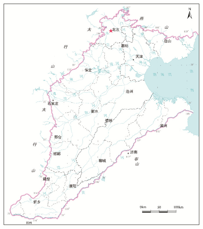
华北平原西依太行山、北靠燕山,东临渤海,南界黄河,包括北京、天津、河北平原全部以及黄河以北的豫北、鲁北平原区,面积约13.9×10⁴ km2(图 1)(张光辉等, 2011;李文鹏等, 2020)。该地区地处半干旱、半湿润大陆性季风气候区,降雨多集中在7—9月,多年平均降水量500~600 mm,滨海地区降雨较多,可达600~700 mm(张宗祜等, 2000;吴爱民等, 2010;张达, 2017)。蒸发量随着气温升高而增加,大致随纬度增加而降低。降水和蒸发时空分布不均,对本区地下水资源及地下水环境产生直接影响。近几十年来,华北地区降雨量与蒸发量总体呈逐渐减少的趋势,其中京津冀地区年均降雨量与蒸发量从20世纪80年代的572 mm和1159 mm分别减少至2000年后的501 mm与1060 mm。
华北平原属海、滦河及黄河水系,发育大小河流近60条,近几十年来地表水资源量显著减小,根据2019年完成的京津冀地区地表水及地下水资源评价,京津冀地区地表水资源量已从20世纪80年代前的172.30×10⁸ m3减少至2000年后的78.4×10⁸ m3,受山区水库截留及地表水过度开发影响,平原区河道逐渐变得常年无水(刘中培等,2012),平原区滦河、潮白河、永定河、滹沱河4条主要河流总流量由20世纪50年代的135.98×10⁸ m3降至2000年的42.91×10⁸ m3,主要河流断流天数由20世纪60年代的69 d增加至2000年的273 d。
2014年南水北调中线工程向华北平原供水,截至2021年,累计向北京供水62×108 m3,向河北供水超过100×108 m3,向天津供水60×108 m3。南水北调供水后,华北平原部分地区的地下水位得到明显回升,其中北京市地下水位最大回升超过11 m(王树芳等, 2019);石家庄市域内滹沱河补水段下段水位回升6.1 m,2019年较2015年滹沱河超采区地下水位平均回升5.93 m(崔向向等, 2020; 田夏等, 2021);2020年年底河北省2/3以上的超采县地下水位下降得到一定遏制。
华北平原区地势平坦,海拔不超过100 m,自北、西、南西3个方向向渤海湾倾斜,坡度从山前1‰~2‰变化至东部临海平原的0.1‰~0.2‰(张兆吉等, 2009a)。在地质构造方面,华北平原隶属于中朝准地台的华北断拗,区内第四纪地层可划分为全新统、上更新统、中更新统、下更新统(陈望和, 1999; 张兆吉等, 2009a)。按成因和形态特征可分为山前冲洪积倾斜平原、中东部冲积平原和滨海冲积海积平原(张宗祜等, 2000)。
在含水层划分上,华北平原地下水主要赋存于第四系孔隙地下含水岩系中,根据其埋藏特征和水力性质,自上而下可划分为4个含水岩组,第Ⅰ含水层组为开放式的浅层地下水,埋深为40~60 m;第Ⅱ至第Ⅳ层为具有承压性质的深层含水层组,埋深分别为120~170 m、250~350 m与350~550 m(陈望和, 1999; 张宗祜, 2005)。在山前平原区,第Ⅰ和第Ⅱ含水层组已混合开采,将这二者统称为浅层地下水,第Ⅲ和第Ⅳ含水层组为深层地下水(陈望和, 1999; 费宇红等, 2009)。在中东部平原,浅层地下水主要赋存在第Ⅰ含水层组,微咸水、咸水广泛分布,深层地下水主要赋存于Ⅱ、Ⅲ含水层组,为主要开采层。
在水资源利用方面,华北平原供水由地表水、地下水、再生水、雨水和海水淡化等共同组成,但是地下水是主要的供水水源,而在地下水供水量中,又以浅层水供水量为主,其占地下水供水量的78.1%。地下水的过度开采造成地下水水位逐年下降。
3. 研究方法及数据来源
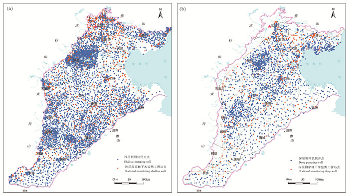
2019—2020年由中国地质科学院水文地质环境地质研究所和中国地质调查局天津地质调查中心牵头,北京市地质环境监测总站、天津市地质环境监测院、河北省地质环境监测院、河南省地质环境监测院、山东省地矿局第二水文地质工程地质大队、山西省第三地质工程勘察院共同参与,完成两期华北平原高密度地下水位统测,统测25158点次(含国家地下水监测工程3918点),其中浅层地下水16792点次,深层地下水8366点次。在山前平原、中部平原等重点区统测密度达到9点/100 km2,东部平原区统测密度达到6点/100 km2,滨海平原区、鲁北平原区统测密度达到5点/100 km2(图 2)。
系统收集《华北平原地下水可持续利用图集》及《华北平原地下水资源可持续利用报告》中1980年和2005年水位数据,以及北京市地质环境监测总站、天津市地质调查研究院、河北省地质环境监测院的2014年水位数据。掌握了国家气象局海河流域范围内1956—2020年56个站点的逐月降雨数据,河北气象局1956—2020年的175个站点逐月降雨数据;整理汇总河北省地质环境监测报告中2001—2015年开采量数据,北京、天津、河南、山东各省水资源公报及2000—2018年海河流域水资源公报等相关数据。
综合以上数据及资料,绘制2019年及2020年华北平原地下水位埋深及水位标高等值线图,圈定了地下水位降落漏斗分布范围;系统分析了1980—2020年地下水流场变化状况,编制了1980—2005年、2005—2014年、2014—2020年深、浅层地下水位变幅图;针对不同典型地区进行了长序列的地下水位动态规律研究,全面分析了华北平原近40年水位变化状况。
4. 结果与讨论
4.1 2020年华北平原地下水流场现状
4.1.1 浅层地下水流场
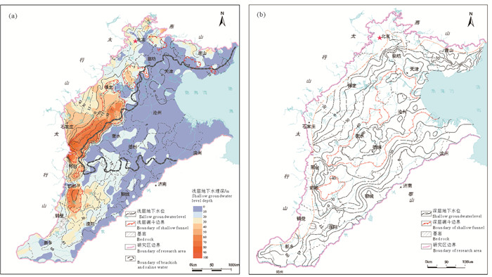
华北平原浅层地下水埋深在东西部有较大差异。考虑地下水位埋深和水文地质条件的差别,自西向东,将华北平原分为“西部山前冲积扇”、“冲洪积扇缘”以及“中东部平原”3个典型区域进行分析。
西部山前冲洪积扇区,主要包括永定河冲积扇、拒马河冲积扇、沙河—唐河冲积扇、滹沱河冲积扇、滏阳河冲积扇及漳卫河冲积扇,地处京广铁路以西的“北京—保定—石家庄—邢台—邯郸”一线,浅层地下水位埋深10~40 m,呈现南北水位埋深小,中部埋深大的分布规律,地下水位标高15~45 m,北部水位低,南部水位高。其中北部“北京—廊坊”一带浅层地下水位埋深10~20 m,水位标高15~30 m;中部“保定—石家庄—邯郸—邢台”一带地区埋深稍大,为20~40 m,水位标高15~45 m;南部“安阳—焦作”一带水位埋深0~20 m,水位标高为30~45 m。
冲洪积扇缘区,主要位于京广铁路沿线两侧区域,浅层地下水位埋深40~70 m,此区域主要以农业区为主,地下水开采强烈,最低水位标高小于-30 m。自北向南,沿着扇缘形成“雄县霸州漏斗”、“高蠡清—宁柏隆漏斗”、“平乡—曲周漏斗”、“邯郸肥乡—广平漏斗”等7个浅层漏斗群,总面积达1.57×10⁴ km2,山前地区各浅层地下水降落漏斗边界不明显,呈现复合连片趋势,其中“高蠡清—宁柏隆漏斗”面积最大,达到了0.95×10⁴ km2,漏斗中心最大水位埋深达103.19 m,位于河北省柏乡县。
中东部平原区,主要涉及天津、沧州、衡水、德州等地。浅层地下水埋深较小,一般在0~10 m,水位标高0~15 m。多为咸水、微咸水,地下水开采较少,水位处于自然波动状态(图 3a)。
4.1.2 深层地下水流场
华北平原深层地下水受开采影响,平原中部与周边水头存在较大差异。根据深层地下水头埋深的变化特征,将华北平原自周边到中部划分为“太行山前平原”、“滦河三角洲”、“山东鲁北地区黄河北岸平原”、“豫北地区黄河北岸平原”及“中东部平原”5个典型区域进行分析。
深层地下水头埋深从平原周边至中东部平原逐渐增大。平原周边地区由于水文地质条件和深层地下水开采程度差异,深层地下水水头存在一定差别:太行山前平原深层水头埋深范围在10~40 m,水头标高范围-15~15 m;滦河三角洲水头埋深较浅,为0~25 m,水头标高-30 m~0;鲁北地区黄河北岸平原深层地下水开采量较小,埋深相对较浅,为5~20 m,水头标高-25~ 0 m;豫北地区黄河北岸平原层水头埋深为5~30 m,水头标高0~40 m。
受农业灌溉强烈开采影响,中东部平原深层地下水头埋深大,形成面积2.38×10⁴ km2的“天津—沧州—衡水—德州复合漏斗”,其中漏斗边界附近的“天津—廊坊—邢台东部”一带,深层地下水头埋深相对较浅,范围在50~80 m,水头标高在-90~-45 m;漏斗中心的“巨鹿—新河”、“衡水阜城—德州”、“沧州”、“黄骅”4个漏斗中心水头埋深平均90~120 m,其中最大水头埋深达到135.78 m,位于衡水景县。
华北平原深层地下水位低于黄海海平面(0 m水位标高等值线)的范围达到了9.02×10⁴ km2(图 3b),占华北平原总面积的65%。
4.2 近40年来华北平原区域地下水位演变特征
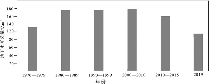
近40年来,华北平原地下水开采量总体呈现先升后降的趋势,以京津冀平原为例,2000—2010年地下水开采量达到历史最高,年均159.22×10⁸ m3/a,2014年后,随着地下水超采治理推进和南水北调中线工程供水,地下水开采量显著下降,2019年地下水开采量降至96.97×108 m3/a(图 4)。受地下水开采量变化影响,地下水位在不同历史阶段变化规律存在明显差异,可分为3个阶段:1980—2010年地下水开采量激增,水位快速下降阶段;2010—2014年开采量总体居高不下,水位加速持续下降,但部分城市启动地下水压采工作,局部地下水位呈现止跌回升;2015—2020年,地下水超采治理及南水北调供水持续推进,城市区水位上升明显,但农业区水位仍持续下降,城区和农业区水位变化差异程度逐渐增大。
4.2.1 浅层地下水位演变
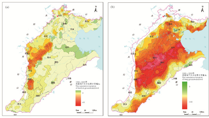
华北平原西部浅层地下水位总体呈下降趋势(图 5),近40年来水位累计降幅20~60 m,其中山前平原北部降幅0~10 m,山前平原中部的“保定—石家庄—邢台—邯郸”冲洪积扇缘一带水位降幅最大,累计降幅达到40~60 m,山前平原南部豫北平原水位降幅较小,在10~20 m;平原中东部浅层地下水呈现自然波动状态(图 5)。
浅层地下水位在不同历史阶段呈现差异变化。1984—2005年,平原大部分地下水水位都处于下降状态,其中西部太行山前平原的“北京—保定—石家庄—邢台”等地区浅层地下水开采量最大,2000—2005年均开采模数为(1.02~1.69)×105 m3/a·km2,水位降速达到1~2 m/a;2005—2014年,西部山前平原浅层地下水开采量持续居高不下,年均开采模数为(0.97~1.47)×105 m3/a·km2,其中“保定—石家庄—邢台”冲洪积扇缘一带水位降速为1~2 m/a,局部地区降速达到3 m/a;2014—2020年,由于南水北调供水及生态补水工程的实施,西部山前冲积扇上大中型城市及主要河道影响带水位出现回升,但目前的生态补水方式相对粗放,水位下降速率最大的冲洪积扇缘处水位降速仍达到2~4 m/a,农业灌溉开采地下水是造成扇缘处水位持续下降的主要原因(表 1)。
表 1 分阶段浅层地下水水位年均降速、降水量、开采模数一览Table 1. Annual decline rate of shallow groundwater level, precipitation and mining module in different periods
4.2.2 深层地下水位演变
近40年以来,华北平原区深层地下水头总体呈大幅度下降趋势,其中下降幅度最大区域位于平原中东部的“天津—沧州—衡水—德州”一带,累计降幅40~90 m,其中衡水—德州地区降幅达到90~110 m;平原周边的燕山山前平原、太行山山前平原以及黄河北岸鲁北平原,深层地下水位降幅相对较小,其中,太行山山前平原降幅20~40 m,滦河三角洲地区水头降幅0~30 m,豫北平原水头降幅20~40 m(图 5)。
近40年来华北平原不同时期深层地下水位变化存在明显差异。1980—2005年,华北平原深层地下水头呈现快速下降状态,其中平原中东部的衡水、沧州等地水头降速最大,达到3~4 m/a,地下水开采模数达到0.58×104 m3/a·km2,农业开采量占比约70%,农业灌溉开采地下水是本区水头快速下降的主要原因;黄河北岸鲁北平原降速相对较小,为1~2 m/a,农业灌溉主要依赖引黄灌溉是本区水头降速较小的主要原因。2005—2020年,华北平原深层地下水水位下降速率呈差异化发展。中东部平原受农业开采影响,开采模数依然为全区最大,达0.59×104 m3/a·km2,农业区水位仍呈快速下降趋势,下降速率达到2~4 m/a;由于早期沧州、天津等城市针对地面沉降防控开展封填井以及2014年后开展地下水超采综合治理、南水北调水源替换工程,主要城区地下水位回升较为明显,水头上升速率1~2 m/a(表 2)。
表 2 分阶段深层地下水水位年均降速、降水量、开采量一览Table 2. Annual decline rate of deep groundwater level, precipitation and extraction in different periods
4.3 典型地貌单元地下水位动态变化特征
4.3.1 浅层地下水位动态变化
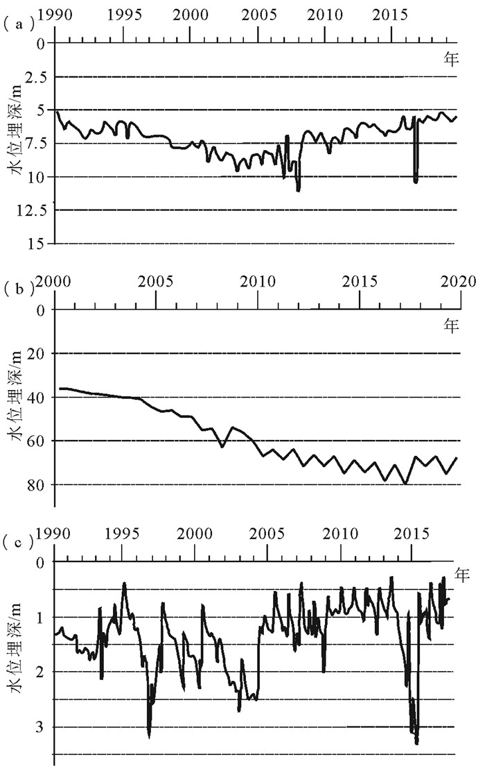
华北平原由西部山前冲洪积扇至中东部平原,浅层地下水位在不同时期呈现不同的动态变化特征。山前冲洪积扇地区地下水位在2000年之前处于持续下降状态,2000年之后水位逐渐减缓呈现小幅抬升。以潮白河冲洪积扇上典型浅层地下水监测井S101(北京市河南村)为例,2000年之前,受地下水开采影响,浅层地下水位持续下降,降速为0.15 m/a,2000—2014年,国家相关部门逐渐重视地下水资源保护和水位恢复,地下水超采治理工作逐步开展,地下位止跌并呈现小幅回升,水位埋深年均上升0.4 m,2014年后,随着南水北调工程供水,以及地下水压采工作推进力度增大,浅层水位继续上升,年均上升0.6 m/a(图 6a)。
![]() 图 6 浅层典型监测井地下水位变化a—潮白河冲积扇, 北京; b—滹沱河冲积扇缘, 石家庄高邑; c—中东部平原, 沧州市区Figure 6. The fluctuation of groundwater level in typical monitoring wells of shallow aquifera-Alluvial fan of the Chaobai River, Beijing; b-Fringe of the Hutuo River alluvial fan, Gaoyi, Shijiazhuang City; c-Central and eastern plain, Cangzhou urban district
图 6 浅层典型监测井地下水位变化a—潮白河冲积扇, 北京; b—滹沱河冲积扇缘, 石家庄高邑; c—中东部平原, 沧州市区Figure 6. The fluctuation of groundwater level in typical monitoring wells of shallow aquifera-Alluvial fan of the Chaobai River, Beijing; b-Fringe of the Hutuo River alluvial fan, Gaoyi, Shijiazhuang City; c-Central and eastern plain, Cangzhou urban district冲洪积扇缘地区地下水位2014年之前呈现持续下降趋势,2014年后降速减缓并逐渐平稳。以滹沱河冲洪积扇缘处的石家庄高邑监测井为例,自2000—2014年,地下水开采强度大,浅层地下水位下降速率增大为3 m/a,农业灌溉开采是造成水位下降的主要原因,2015年后由于南水北调工作的推进,城市生活及工业用水逐渐被南水北调水源置换,地下位变化主要受到农业灌溉季节性开采地下水的影响,表现为震荡缓慢下降(图 6b)。
中东部平原地区浅层地下水以咸水、微咸水为主,开发利用极少,水位动态特征主要表现为缓慢波动趋势。以沧州市区浅层监测井为例,2000年之前,水位埋深基本维持在1.5 m处上下波动,2000年后水位总体呈现抬升趋势(图 6c)。
4.3.2 深层地下水位动态变化
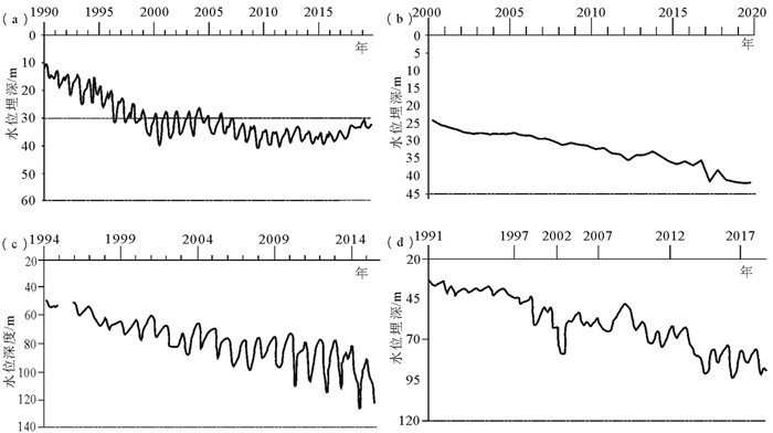
华北平原东西部深层地下水头变化差异明显。西部山前平原深层地下水头2000年之前以持续下降为主,近年来水位基本保持稳定或局部小幅抬升。以太行山前平原北段的北京监测井为例,深层承压水水头自1990—2000年呈现快速下降趋势,累计降幅20 m,城市及农业的强烈开采是主要原因;2001—2014年深层水位小幅下降,2014年后随着南水北调工程及地下水压采工作深入推进,该监测井水头回升较为明显,2015—2019年地下水头上升7.2 m,年均上升1.8 m(图 7a)。太行山前平原中段雄安新区的深层地下水监测井水头呈现持续下降趋势,2014年之前深层水头降速为0.8 m/a,2014至今,受到南水北调置换深层地下水开采以及近年来的河道生态补水的影响,深层地下水头降幅减缓明显(图 7b)。
![]() 图 7 深层典型监测井地下水位变化a—潮白河冲积扇, 北京; b—拒马河冲积扇缘, 雄安; c—中东部平原, 衡水景县; d—中东部平原, 沧州南皮县Figure 7. The fluctuation of groundwater level in typical monitoring wells of deep aquifersa-Alluvial fan of the Chaobai River, Beijing; b- Fringe of Juma River alluvial fan, Xiong'an; c-Central and eastern plains, Jingxian County, Hengshui City; d-Central and eastern plains, Nanpi County, Cangzhou City
图 7 深层典型监测井地下水位变化a—潮白河冲积扇, 北京; b—拒马河冲积扇缘, 雄安; c—中东部平原, 衡水景县; d—中东部平原, 沧州南皮县Figure 7. The fluctuation of groundwater level in typical monitoring wells of deep aquifersa-Alluvial fan of the Chaobai River, Beijing; b- Fringe of Juma River alluvial fan, Xiong'an; c-Central and eastern plains, Jingxian County, Hengshui City; d-Central and eastern plains, Nanpi County, Cangzhou City中东部平原深层地下水头动态特征总体表现为震荡快速下降趋势,表明水头变化主要受到季节性农业灌溉开采影响。以衡水市东部景县典型深层地下水位监测井为例(图 7c),1994年至今深层地下水头持续下降,水头埋深累计增加近70 m,年均水位下降速率达到2 m/a。同样,沧州南皮县的深层水头观测井也显示(图 7d),深层地下水头呈持续快速下降趋势,并且2000年以后,年均下降速率由之前的0.6 m/a增加至1.1 m/a,下降速率增加了近1倍,近30年累计降幅达到60 m。农业灌溉无替代水源,依赖超采地下水是造成中东部平原深层地下水头持续下降的关键因素。
5. 结论
(1)近40年来,华北平原地下水长期超采导致水位显著下降,形成规模巨大的降落漏斗,地下水超采治理后地下水位下降趋势有所减缓,但地下水降落漏斗范围仍有扩大,且呈连片趋势发展。
(2)华北平原东西部浅层地下水呈现差异化发展,20世纪80年代至2014年平原西部浅层地下水持续快速下降,累计降幅达20~60 m,太行山前“保定—石家庄—邢台”冲洪积扇缘一带水位降幅最大,累计降幅达到60~70 m;2014年地下水超采治理和南水北调工程供水后,西部山前主要城市水位止跌回升;深层地下水头20世纪80年代至2014年,总体呈下降趋势,中东部地区水头降幅度最大,累计降幅40~90 m,其中衡水、沧州地区水头下降幅度最大,降幅为90~110 m;2014年后城市区与农业区深层地下水头呈差异化发展,城区水位回升明显,周边农业区仍呈下降趋势。
(3)地下水超采治理、南水北调供水、河湖生态补水及农业节水等措施已初见成效,以城区为主的地下水位已经止跌并小幅回升,但地下水长期采补失衡形成的地下水位降落漏斗规模依然巨大,需通过进一步实施相关治理及修复措施,以实现采补平衡和地下水位逐步恢复。
6. 建议
华北平原地下水超采治理及降落漏斗修复已开展大量的研究工作,但仍存在诸多问题,主要包括:地下水超采区水位恢复的控制目标亟待明确;地下水超采治理亟需精细化治理方案;地下水超采治理评估的监测体系尚待优化;地下水超采治理措施以控采为主,增补及水源置换等相关研究不够。因此,为进一步遏制华北平原地下水位持续下降态势,实现地下水采补平衡,支撑地下水超采及漏斗的精准治理和修复,提出以下建议:
(1)以地下水头降落漏斗治理和水生态环境改善为目标,开展超采区水位恢复阈值研究。浅层地下水位恢复阈值应主要考虑浅层地下水位降落漏斗修复目标水位、大中型城市地下空间安全保障水位、中东部平原土壤盐渍化防控水位以及湿地生态维系水位等因素研究设置目标水位。深层地下水头恢复阈值则需重点考虑深层地下水漏斗修复和地面沉降防控需求,按地面沉降严重、较严重、一般沉降区分别研究设置目标水位。
(2)以实现采补平衡和地下水位逐步恢复为目标,研究华北平原地下水超采精准治理方案。浅层地下水建议采用地下水减采和回补协同方案;深层地下水建议采用地下水减采和多水源置换分阶段推进方案,可在中东部平原沧州、衡水等地着力推进以咸置淡,充分利用浅层微咸水、减少深层淡水开采,同时考虑南水北调东线二期工程地表水置换深层地下水。依据水利部等四部委《华北地区地下水超采综合治理行动方案》,力争2035年实现采补平衡,2050年达到水位恢复。
(3)优化地下水监测网,支撑地下水超采治理实时监测评估。统筹国家地下水监测工程和各省(市)地下水和地面沉降监测站点,根据地下水超采区、地下水位降落漏斗区和地面沉降区分布特征,开展监测网优化,充分利用物联网、云平台等新技术,构建“水位—水量—水质一体化在线化监测评估体系”,实现地下水超采治理效果实时监测评估。
(4)充分发挥南水北调工程作用,加快华北地下水超采综合治理。充分运用南水北调中线工程地表水库、地下水水库开展联合调蓄,在山前冲洪积扇卵砾石区带、粗砂含砾石区带以及平原古河道带,可采用人工坑塘及天然河道等回补靶区,进行本地地表水、南水北调中线供水、雨洪水等多水源联合高效回补;在中东部地区,结合南水北调东线二期工程,探索在深层地下水降落漏斗中心区及地面沉降严重区进行井灌加压回补,同时研究南水北调中东线二期工程用于农业灌溉可行性,加强从干渠到田间的灌溉渠网规划建设,逐步置换农业灌溉开采水源,减少深层地下水开采。
-
图 6 浅层典型监测井地下水位变化
a—潮白河冲积扇, 北京; b—滹沱河冲积扇缘, 石家庄高邑; c—中东部平原, 沧州市区
Figure 6. The fluctuation of groundwater level in typical monitoring wells of shallow aquifer
a-Alluvial fan of the Chaobai River, Beijing; b-Fringe of the Hutuo River alluvial fan, Gaoyi, Shijiazhuang City; c-Central and eastern plain, Cangzhou urban district
图 7 深层典型监测井地下水位变化
a—潮白河冲积扇, 北京; b—拒马河冲积扇缘, 雄安; c—中东部平原, 衡水景县; d—中东部平原, 沧州南皮县
Figure 7. The fluctuation of groundwater level in typical monitoring wells of deep aquifers
a-Alluvial fan of the Chaobai River, Beijing; b- Fringe of Juma River alluvial fan, Xiong'an; c-Central and eastern plains, Jingxian County, Hengshui City; d-Central and eastern plains, Nanpi County, Cangzhou City
表 1 分阶段浅层地下水水位年均降速、降水量、开采模数一览
Table 1 Annual decline rate of shallow groundwater level, precipitation and mining module in different periods

表 2 分阶段深层地下水水位年均降速、降水量、开采量一览
Table 2 Annual decline rate of deep groundwater level, precipitation and extraction in different periods

-
Chen Wanghe. 1999. Hebei Groundwater[M]. Beijing: Seismological Press(in Chinese with English abstract).
Cui Xiangxiang, Fei Yuhong, Meng Suhua, Tian Xia. 2020. The influence of water level recovery on groundwater pollution risk assessment in over exploitation area[J]. Agricultural Science, (11): 153-156(in Chinese with English abstract).
Cui Yali, Wang Yabin, Shao Jingli, Chi Yaping, Lin Li. 2009. Research on groundwater regulation and recovery in North China Plain after the implementation of South-to-North Water Transfer[J]. Resources Science, 31(3): 382-387(in Chinese with English abstract).
Fei Yuhong, Miao Jinxiang, Zhang Zhaoji, Chen Zongyu, Song Haibo, Yang Mei. 2009. Analysis on evolution of groundwater depression cones and its leading factors in North China Plain[J]. Resources Science, 31(3): 394-399(in Chinese with English abstract). http://en.cnki.com.cn/Article_en/CJFDTOTAL-ZRZY200903011.htm
Hu Chunsheng, Zhang Xiying, Cheng Yisong, Pei Dong. 2002. An analysis on dynamics of water table and overdraft of groundwater in the piedmont of Mt. Taihang[J]. System Sciences and Comprehensive Studies in Agriculture, 18(2): 89-91, 95(in Chinese with English abstract). doi: 10.1007/s11703-011-1149-4
Li Wenpeng, Wang longfeng, Yang Huifeng, Zheng Yuejun, Cao Wengeng, Liu Ke. 2020. The groundwater overexploitation status and countermeasure suggestions of the North China Plain[J]. China Water Resources, (13): 26-30(in Chinese with English abstract).
Liu Changming, Yu Jingjie, Kendy E. 2001. Groundwater exploitation and its impact on the environment in the North China Plain[J]. Water International, 26(2): 265-272. doi: 10.1080/02508060108686913
Liu Meiying, Min Leilei, Shen Yanjun, Wu Lin. 2020. Evaluating the impact of alternative cropping systems on groundwater consumption and nitrate leaching in the piedmont area of the North China Plain[J]. Agronomy, 10(11): 1635. doi: 10.3390/agronomy10111635
Liu Zhongpei, Wang Fuqiang, Yu Furong. 2012. Variation of shallow groundwater level in Shijiazhuang Plain[J]. South-to-North Water Transfers and Water Science & Technology, 10(5): 124-127(in Chinese with English abstract). http://en.cnki.com.cn/Article_en/CJFDTOTAL-NSBD201205029.htm
Qian Yong, Zhang Zhaoji, Fei Yuhong, Chen Jingsheng, Zhang Fenge, Wang Zhao. 2014. Sustainable exploitable potential of shallow groundwater in the North China Plain[J]. Chinese Journal of Eco-Agriculture, (8): 890-897(in Chinese with English abstract). http://en.cnki.com.cn/Article_en/CJFDTOTAL-ZGTN201408006.htm
Shao Jingli, Zhao Zongzhuang, Cui Yali, Wang Rong, Li Changqing, Yang Qiqing. 2009. Application of groundwater modeling system to the evaluation of groundwater resources in North China Plain[J]. Resources Science, 31(3): 361-367(in Chinese with English abstract). http://en.cnki.com.cn/Article_en/CJFDTOTAL-ZRZY200903006.htm
Shao Jingli, Li Ling, Cui Yali, Zhang Zhaoji. 2013. Groundwater flow simulation and its application in groundwater resource evaluation in the North China Plain, China[J]. Acta Geologica Sinica(English Edition), 87(1): 243-253. doi: 10.1111/1755-6724.12045
Shi Jiansheng, Li Guomin, Liang Xing, Chen Zongyu, Shao Jingli, Song Xianfang. 2014. Evolution mechanism and control of groundwater in the North China Plain[J]. Acta Geoscientica Sinica, 35(5): 527-534(in Chinese with English abstract) http://en.cnki.com.cn/Article_en/CJFDTOTAL-DQXB201405001.htm
Shi Jiansheng, Wang Zhao, Zhang Zhaoji, Fei Yuhong, Li Yasong, Zhang Fenge, Chen Jingsheng, QianYong. 2010. Assessment of over-exploitation of deep groundwater in the North China Plain[J]. Earth Science Frontiers, 17(6): 215-220(in Chinese with English abstract). https://core.ac.uk/display/260224539
Sun Hongyong, Zhang Xiying, Liu Xiujing, Liu Xiuwei, Shao Liwei, Chen Suying, Wang Jintao, Dong Xinliang. 2019. Impact of different cropping systems and irrigation schedules on evapotranspiration, grain yield and groundwater level in the North China Plain[J]. Agricultural Water Management, 211: 202-209. doi: 10.1016/j.agwat.2018.09.046
Tian Xia, Meng Suhua, Cui Xiangxiang, Zhang Xueqing, Zhang Zhaoji, Fei Yuhong. 2021. Hydrochemical effect of groundwater recharge in over-exploitated area of Hutuo River Basin[J]. Research of Environmental Sciences, 34(3): 629-636(in Chinese with English abstract).
Wang Guiling, Chen Dehua, Lin Wenjing, Fan Qi, Zhang Wei. 2007. Reasonable exploitation and utilization of groundwater resource in North China[J]. Journal of Desert Research, 27(4): 684-689(in Chinese with English abstract). https://core.ac.uk/display/155345068
Wang Shufang, Li Jie, Liu Yuanzhang, Liu Jiurong, Wang Xu. 2019. Impact of South -to -North Water Diversion on groundwater recovery in Beijing[J]. China Water Resources, (7): 26-30 (in Chinese with English abstract).
Wang Xiaoguang, Guo Changlai, He Haiyang, Liu Qiang. 2019. Study on the classification of groundewater depression cone[J]. Geology and Resources, 28(5): 487-492(in Chinese with English abstract). http://en.cnki.com.cn/Article_en/CJFDTotal-GJSD201905012.htm
Wei Lei, Yang Guilian, Lu Chengpeng, Sun Long, Yu Po, Li Yan. 2019. Analysis of buried depth variation and controlling factors of shallow groundwater overexploited areas of in North China Plain[J]. Journal of Water Resources and Water Engineering, 30(6): 39-44. (in Chinese with English abstract)
Wu Aimin, Li Changqing, Xu Yanze, Liu Jiurong, Luo Guozhong. 2010. Key issues influencing sustainable groundwater utilization and its counter measures in North China Plain[J]. South-to-North Water Transfers and Water Science & Technology, 8(6): 110-113, 128(in Chinese with English abstract). http://en.cnki.com.cn/Article_en/CJFDTOTAL-NSBD201006036.htm
Wu Xifang, Qi Yongqing, Shen Yanjun, Yang Wei, Zhang Yucui, Akihiko Kondoh. 2019. Change of winter wheat planting area and its impacts on groundwater depletion in the North China Plain[J]. Journal of Geographical Sciences, 29(6): 891-908. doi: 10.1007/s11442-019-1635-9
Xie Xinmin, Chai Fuxin, Yan Yong, Zhang Jiqun, Yang Lili. 2007. Preliminary study on critical depth of ground water table[J]. Ground Water, 29(6): 47-50, 64(in Chinese with English abstract). http://gateway.proquest.com/openurl?res_dat=xri:pqm&ctx_ver=Z39.88-2004&rfr_id=info:xri/sid:baidu&rft_val_fmt=info:ofi/fmt:kev:mtx:article&genre=article&jtitle=Ground%20Water&atitle=Preliminary%20Study%20on%20Critical%20Depth%20of%20Ground%20Water%20Table
Xu Guangming, Liu Lijun, Fei Yuhong, Li Duo, Qian Yong. 2009. Research on the adjustment of groundwater storage in North China Plain[J]. Resources Science, 31(3): 375-381(in Chinese with English abstract). http://en.cnki.com.cn/Article_en/CJFDTOTAL-ZRZY200903008.htm
Xu Yueqing, Mo Xingguo, Cai Yunlong, Li Xiubin. 2005. Analysis on groundwater table drawdown by land use and the quest for sustainable water use in the Hebei Plain in China[J]. Agricultural Water Management, 75(1): 38-53. doi: 10.1016/j.agwat.2004.12.002
Yu Lilia, Ling Minhua, Chen Feia, Ding Yueyuan, Lü Cuimei. 2020. Practices of groundwater over-exploitation control in Hebei Province[J]. Water Policy, 22(4): 591-601. doi: 10.2166/wp.2020.183
Yuan Kunlin, Yang Zhihai, Wang Shuhong. 2021. Water scarcity and adoption of water-saving irrigation technologies in groundwater over-exploited areas in the North China Plain[J]. Irrigation Science: 39(3): 397-408. doi: 10.1007/s00271-021-00726-2
Zhang Da. 2017. Study of the Allowable Groundwater Withdrawal in the North China Plain based on Environmental Limited Groundwater Level[D]. Beijing: China University of Geosciences (Beijing)(in Chinese with English abstract).
Zhang Guanghui, Fei Yuhong, Liu Chunhua, Feng Huimin, Yan Mingjiang, Wang Jinzhe. 2013. Relationship between decline of shallow groundwater levels and irrigated agriculture on Hufu Plain of North China[J]. Advances in Water Science, 24(2): 228-234. (in Chinese with English abstract) http://en.cnki.com.cn/Article_en/CJFDTOTAL-SKXJ201302012.htm
Zhang Guanghui, Fei Yuhong, Liu Keyan. 2004. Groundwater Evolution and Countermeasure in Haihe Plain[M]. Beijing: Science Press (in Chinese).
Zhang Guanghui, Lian Yingli, Liu Chunhua, Yan Mingjiang, Wang Jinzhe. 2011. Situation and origin of water resources in short supply in North China Plain[J]. Journal of Earch Sciences and Environment, 33(2): 172-176(in Chinese with English abstract). http://en.cnki.com.cn/Article_en/CJFDTOTAL-XAGX201102014.htm
Zhang Menglin, Hu Litang, Yao Lili, Yin Wenjie. 2018. Numerical studies on the influences of the South-to-North Water Transfer Project on groundwater level changes in the Beijing Plain, China[J]. Hydrological Processes, 32(12): 1858-1873. doi: 10.1002/hyp.13125
Zhang Zhaoji, Fei Yuhong, Chen Zongyu, Zhao Zongzhuang, Xie Zhenhua, Wang Yabin, Miao Jinxiang, Yang Lizhi, Shao Jingli, Jin Menggui, Xu Guangming, Yang Qiqing. 2009a. Investigation and evaluation of sustainable utilization of Groundwater in North China Plain[M]. Beijing: Geology Publishing House(in Chinese with English abstract).
Zhang Zhaoji, Luo Guozhong, Wang Zhao, Liu Chunhua, Li Yasong, Jiang Xianqiao. 2009b. Study on sustainable utilization of groundwater in North China Plain[J]. Resources Science, 31(3): 355-360. (in Chinese with English abstract). http://en.cnki.com.cn/Article_en/CJFDTOTAL-ZRZY200903005.htm
Zhang Zonghu, Shen Zhaoli, Shi Dehong, Xue Yiqun. 1997a. Evolution and development of groundwater environment in North China Plain under human activities[J]. Acta Geoscientia Sinica, (4): 2-9(in Chinese with English abstract). http://en.cnki.com.cn/Article_en/CJFDTOTAL-DQXB704.000.htm
Zhang Zonghu, Shen Zhaoli, Xue Yuqun. 2000. Groundwater Environmental Evolution in North China Plain[M]. Beijing: Geological Publishing House(in Chinese with English abstract).
Zhang Zonghu, Shi Dehong, Ren Fuhong, Yin Zhengzhou, Sun Jichao, Zhang Cuiyun. 1997b. On the evolution of the Quaternary groundwater system in the North China Plain[J]. Science in China(Series D: Earth Sciences), (2): 168-173(in Chinese). doi: 10.1007%2FBF02877536/metrics
Zhang Zonghu. 2005. Groundwater in the Vast North China Plain[J]. Nature Magazine, 27(6): 311-315(in Chinese). http://www.zhangqiaokeyan.com/academic-journal-cn_chinese-journal-nature_thesis/020121198672.html
Zhang Xiying, Pei Dong, Hu Chunsheng. 2003. Conserving groundwater for irrigation in the North China Plain[J]. Irrigation Science, 21(4): 159-166. doi: 10.1007/s00271-002-0059-x
Zhao Hui, Chen Wenfang, Cui Yali. 2010. Control function of groundwater table on the environment of typical areas in China and the study of thresholds[J]. Earth Science Frontiers, 17(6): 159-165(in Chinese with English abstract). http://en.cnki.com.cn/Article_en/CJFDTOTAL-DXQY201006021.htm
Zhu Lin, Gong Huili, Chen Yun, Wang Shufang, Ke Yinhai, Guo Gaoxuan, Li Xiaojuan, Chen Beibei, Wang Haigang, Pietro Teatini. 2020. Effects of water diversion project on groundwater system and land subsidence in Beijing, China[J]. Engineering Geology, 276: 105763. doi: 10.1016/j.enggeo.2020.105763
Zhu Juyan, Guo Haipeng, Li Wenpeng, Tian Xiaowei. 2014. Relationship between land subsidence and deep groundwater yield in the North China Plain[J]. South-to-North Water Transfers and Water Science & Technology, 12(3): 165-169(in Chinese with English abstract).
陈望和. 1999. 河北地下水[M]. 北京: 地震出版社. 崔向向, 费宇红, 孟素花, 田夏. 2020. 水位回升对超采区地下水污染风险评价的影响研究[J]. 农业科学, (11): 153-156. doi: 10.3969/j.issn.0517-6611.2020.11.043 崔亚莉, 王亚斌, 邵景力, 池娅萍, 林坜. 2009. 南水北调实施后华北平原地下水调控研究[J]. 资源科学, 31(3): 382-387. doi: 10.3321/j.issn:1007-7588.2009.03.005 费宇红, 苗晋祥, 张兆吉, 陈宗宇, 宋海波, 杨梅. 2009. 华北平原地下水降落漏斗演变及主导因素分析[J]. 资源科学, 31(3): 394-399. doi: 10.3321/j.issn:1007-7588.2009.03.007 胡春胜, 张喜英, 程一松, 裴冬. 2002. 太行山前平原地下水动态及超采原因分析[J]. 农业系统科学与综合研究, 18(2): 89-91, 95. doi: 10.3969/j.issn.1001-0068.2002.02.003 李文鹏, 王龙凤, 杨会峰, 郑跃军, 曹文庚, 刘可. 2020. 华北平原地下水超采状况与治理对策建议[J]. 中国水利, (13): 26-30. https://www.cnki.com.cn/Article/CJFDTOTAL-SLZG202013020.htm 刘中培, 王富强, 于福荣. 2012. 石家庄平原区浅层地下水位变化研究[J]. 南水北调与水利科技, (5): 124-127. https://www.cnki.com.cn/Article/CJFDTOTAL-NSBD201205029.htm 钱永, 张兆吉, 费宇红, 陈京生, 张凤娥, 王昭. 2014. 华北平原浅层地下水可持续利用潜力分析[J]. 中国生态农业学报, (8): 890-897. https://www.cnki.com.cn/Article/CJFDTOTAL-ZGTN201408006.htm 邵景力, 赵宗壮, 崔亚莉, 王荣, 李长青, 杨齐青. 2009. 华北平原地下水流模拟及地下水资源评价[J]. 资源科学, 31(3): 361-367. doi: 10.3321/j.issn:1007-7588.2009.03.002 石建省, 李国敏, 梁杏, 陈宗宇, 邵景力, 宋献方. 2014. 华北平原地下水演变机制与调控[J]. 地球学报, (5): 527-534. https://www.cnki.com.cn/Article/CJFDTOTAL-DQXB201405001.htm 石建省, 王昭, 张兆吉, 费宇红, 李亚松, 张凤娥, 陈京生, 钱永. 2010. 华北平原深层地下水超采程度计算与分析[J]. 地学前缘, 17(6): 215-220. https://www.cnki.com.cn/Article/CJFDTOTAL-DXQY201006029.htm 田夏, 孟素花, 崔向向, 张学庆, 张兆吉, 费宇红. 2021. 滹沱河超采区地下水回补的水化学效应研究[J]. 环境科学研究, 34(3): 629-636. https://www.cnki.com.cn/Article/CJFDTOTAL-HJKX202103013.htm 王贵玲, 陈德华, 蔺文静, 范琦, 张薇. 2007. 中国北方地区地下水资源的合理开发利用与保护[J]. 中国沙漠. 27(4): 684-689. doi: 10.3321/j.issn:1000-694X.2007.04.027 王树芳, 李捷, 刘元章, 刘久荣, 王旭. 2019. 南水北调对北京地下水涵养的影响[J]. 中国水利, (7): 26-30. doi: 10.3969/j.issn.1000-1123.2019.07.008 王晓光, 郭常来, 何海洋, 刘强. 2019. 地下水降落漏斗分类研究[J]. 地质与资源, 28(5): 487-492. doi: 10.3969/j.issn.1671-1947.2019.05.012 卫磊, 杨桂莲, 鲁程鹏, 孙龙, 于钋, 李岩. 2019. 华北平原超采区浅层地下水埋深变化及控制因素分析[J]. 水资源与水工程学报, 30(6): 39-44. https://www.cnki.com.cn/Article/CJFDTOTAL-XBSZ201906007.htm 吴爱民, 李长青, 徐彦泽, 刘久荣, 雒国忠. 2010. 华北平原地下水可持续利用的主要问题及对策建议[J]. 南水北调与水利科技, 8(6): 110-113, 128. https://www.cnki.com.cn/Article/CJFDTOTAL-NSBD201006036.htm 谢新民, 柴福鑫, 颜勇, 张继群, 杨丽丽. 2007. 地下水控制性关键水位研究初探[J]. 地下水, 29(6): 47-50, 64. doi: 10.3969/j.issn.1004-1184.2007.06.015 许广明, 刘立军, 费宇红, 李铎, 钱永. 2009. 华北平原地下水调蓄研究[J]. 资源科学, 31(3): 375-381. doi: 10.3321/j.issn:1007-7588.2009.03.004 张达. 2017. 基于环境约束水位的华北平原地下水可开采资源量研究[D]. 北京: 中国地质大学(北京). 张光辉, 费宇红, 刘春华, 冯慧敏, 严明疆, 王金哲. 2013. 华北滹滏平原地下水位下降与灌溉农业关系[J]. 水科学进展, 24(2): 228-234. https://www.cnki.com.cn/Article/CJFDTOTAL-SKXJ201302012.htm 张光辉, 费宇红, 刘克岩. 2004. 海河平原地下水演变与对策[M]. 北京: 科学出版社. 张光辉, 连英立, 刘春华, 严明疆, 王金哲. 2011. 华北平原水资源紧缺情势与因源[J]. 地球科学与环境学报, 33(2): 172-176. doi: 10.3969/j.issn.1672-6561.2011.02.012 张兆吉, 费宇红, 陈宗宇, 赵宗壮, 谢振华, 王亚斌, 苗晋祥, 杨丽芝, 邵景力, 靳孟贵, 许广明, 杨齐青. 2009a. 华北平原地下水可持续利用调查评价[M]. 北京: 地质出版社. 张兆吉, 雒国中, 王昭, 刘春华, 李亚松, 姜先桥. 2009b. 华北平原地下水资源可持续利用研究[J]. 资源科学, 31(3): 355-360. https://www.cnki.com.cn/Article/CJFDTOTAL-ZRZY200903005.htm 张宗祜. 2005. 华北大平原地下水的历史和现状[J]. 自然杂志, 27(6): 311-315. doi: 10.3969/j.issn.0253-9608.2005.06.001 张宗祜, 沈照理, 施德鸿, 薛禹群. 1997a. 人类活动影响下华北平原地下水环境的演化与发展[J]. 地球学报, (4): 2-9. https://www.cnki.com.cn/Article/CJFDTOTAL-DQXB704.000.htm 张宗祜, 沈照理, 薛禹群. 2000. 华北平原地下水环境演化[M]. 北京: 地质出版社. 张宗祜, 施德鸿, 任福弘, 殷正宙, 孙继朝, 张翠云. 1997b. 论华北平原第四系地下水系统之演化[J]. 中国科学(D辑: 地球科学), (2): 168-173. https://www.cnki.com.cn/Article/CJFDTOTAL-JDXK199702012.htm 赵辉, 陈文芳, 崔亚莉. 2010. 中国典型地区地下水位对环境的控制作用及阈值研究[J]. 地学前缘, 17(6): 159-165. https://www.cnki.com.cn/Article/CJFDTOTAL-DXQY201006021.htm 朱菊艳, 郭海朋, 李文鹏, 田小伟. 2014. 华北平原地面沉降与深层地下水开采关系[J]. 南水北调与水利科技, 12(3): 165-169. https://www.cnki.com.cn/Article/CJFDTOTAL-NSBD201403036.htm -
期刊类型引用(55)
1. 冯锐. 明·华北挑战更严峻——漫步地震五千年(13). 地震科学进展. 2025(02): 108-124 .  百度学术
百度学术
2. 管清花,题宇洋,吴现爱,陈凤琴,陈学群,仇钰婷. 基于分层监测的滨海地区地下水水化学特征分析. 济南大学学报(自然科学版). 2025(01): 29-37 .  百度学术
百度学术
3. 左雪峰,侯新伟,李向全,王振兴,桂春雷,高明,李金秋. 邯郸山前平原地下水流场演变及其驱动力. 人民黄河. 2024(02): 100-106 .  百度学术
百度学术
4. 焦华喆,陈曦,张铁岗,杨柳华,陈新明,HONAKER Rick,马俊伟,余洋. 黄河流域煤炭开发区地下水污染成因分析及防治建议. 中国地质. 2024(01): 143-156 .  本站查看
本站查看
5. 孟瑞芳,杨会峰,包锡麟,徐步云,李磊,李谨丞. 京津冀平原非常规水资源利用前景分析及其生态环境效应. 中国地质. 2024(01): 221-233 .  本站查看
本站查看
6. 南天,曹文庚,任印国,孙龙,高媛媛. 京津冀平原浅层地下水漏斗演变规律与影响因素. 南水北调与水利科技(中英文). 2024(01): 110-121 .  百度学术
百度学术
7. 汪洋,朱小龙,白雪山,单强,张旭虎,田西昭. 华北平原水源地水文地球化学演变特征及机制. 人民长江. 2024(03): 59-67 .  百度学术
百度学术
8. 刘清华,吴彬,武刚,高凡,杜明亮,曹伟. 超采背景下地下水化学特征演变及机制分析——以新疆昌吉州东部奇台县为例. 环境科学学报. 2024(04): 168-178 .  百度学术
百度学术
9. 王倩,李高超,李翔宇,郑晓敏,徐晶,徐征和. 基于灰色模型的鲁西北平原水资源供需平衡分析. 黑龙江大学自然科学学报. 2024(02): 191-199 .  百度学术
百度学术
10. 王积才. 不同水文地质条件下地下水污染修复策略差异的对比研究. 农村科学实验. 2024(08): 37-39 .  百度学术
百度学术
11. 张超伟,刘运才,左世诚,李思慧,来尚婧,董杰,廖明生. 利用时序InSAR技术开展大型调水工程变形监测. 地理空间信息. 2024(07): 76-79+124 .  百度学术
百度学术
12. 李绪润,李兆,张秋英,李发东,付伟章. 华北平原禹城地区地下水埋深对地下水及土壤水分和盐分分布的试验研究. 灌溉排水学报. 2024(S1): 108-119 .  百度学术
百度学术
13. 徐腾,王以鹏,叶逾,谢一凡,沈城吉,南统超,鲁春辉. 地下水超采管控体系及水量-水位双控体系研究进展. 水资源保护. 2024(04): 27-35+81 .  百度学术
百度学术
14. 孙楷雯,闵雷雷,王玉才,刘美英,沈彦俊. 华北山前平原典型站点地下水位与硝酸盐变化特征. 中国生态农业学报(中英文). 2024(08): 1411-1419 .  百度学术
百度学术
15. 黄爽兵,谢遵滨,轩晨飞,钱永. 环丙沙星在地下水灌区土壤的吸附解吸特征. 环境科学与技术. 2024(07): 91-98 .  百度学术
百度学术
16. 谭丽丽,冯璞玉,刘德立,乔学瑾,李保国. 气候变化条件下海河平原作物灌溉策略优化模拟. 农业工程学报. 2024(16): 84-93 .  百度学术
百度学术
17. 汪洋,唐立强,王昕洲,单强,马丙太,赵德刚,王颖,周一文,李红超,邵思慧. 冀东平原第四系地下水化学成因及赋存层位识别研究——以唐山平原区为例. 水资源与水工程学报. 2024(05): 31-39 .  百度学术
百度学术
18. 刘燚,康凤新,张文强,许庆宇,秦鹏,赵强,李嘉龙,崔洋,隋海波,郑婷婷. 济南长孝岩溶水系统地下水富集区补给源识别及其成因机制. 地质科技通报. 2024(06): 292-305 .  百度学术
百度学术
19. 钮新强,吴永妍,王磊,颜天佑,李建贺. 高质量建设国家水网工程的思考与建议. 中国工程科学. 2024(06): 108-119 .  百度学术
百度学术
20. 刘鹏飞,刘少玉,周晓妮,王哲,张光辉,崔尚进. 华北平原典型区不同砂层井灌中水位水量变化差异特征——以滹沱河冲洪积扇藁城段为例. 科学技术与工程. 2023(02): 502-508 .  百度学术
百度学术
21. 徐廷云,杨魁,徐骏千,李振河,何国峰. 天津滨海新区地面沉降多维立体监测分析方法研究. 工程勘察. 2023(03): 33-39 .  百度学术
百度学术
22. 徐步云,杨会峰,白华,宋博,孟瑞芳. 保定平原区地下水水位变幅带自由孔隙率空间变异研究. 水文地质工程地质. 2023(03): 23-33 .  百度学术
百度学术
23. 王倩,李高超,翟磊,郑晓敏,徐征和. 典型地下水漏斗区超采综合治理与关键技术优化设计. 水力发电. 2023(06): 14-19+33 .  百度学术
百度学术
24. 孙自森,孙自友. 海河平原地下水超采情势及应对策略探究. 价值工程. 2023(08): 155-157 .  百度学术
百度学术
25. Rui-fang Meng,Hui-feng Yang,Xi-lin Bao,Bu-yun Xu,Hua Bai,Jin-cheng Li,Ze-xin Liang. Optimizing groundwater recharge plan in North China Plain to repair shallow groundwater depression zone, China. Journal of Groundwater Science and Engineering. 2023(02): 133-145 .  必应学术
必应学术
26. 井江楠,王文科,段磊,马嘉骏,马稚桐,石涵月. 保定平原地下水均衡要素变化解析. 水文地质工程地质. 2023(04): 115-126 .  百度学术
百度学术
27. 李中建,靳宛松. “藏粮于地、藏粮于技”战略下保障粮食安全的机制与意义. 中国集体经济. 2023(23): 32-36 .  百度学术
百度学术
28. 尤斌昊,叶淑君,田芳,罗勇. 北京南部沉降区黏土层变形特征和参数分析. 高校地质学报. 2023(04): 590-599 .  百度学术
百度学术
29. 林刚,付晶莹,江东,赵亚楠. 中国煤炭去产能的水资源协同效益分析. 煤炭科学技术. 2023(07): 187-196 .  百度学术
百度学术
30. Yu-chen Tian,Xu-jiao Zhang,Zhi-qiang Yin,Hai Shao,Ming-xu Gu,Yingying-Ding,Chao Peng,Xiang-ge Zhang. Late Quaternary fluvial terrace formation in the Luan River drainage basin, north China and its possible linkages with climate change and tectonic activation. China Geology. 2023(03): 395-408 .  必应学术
必应学术
31. 陈慧,赵鑫宇,常帅,宋圆梦,卢梦淇,赵波,陈昊达,高赛,王琳静,崔建升,张璐璐. 华北平原典型城市(石家庄)地下水重金属污染源解析与健康风险评价. 环境科学. 2023(09): 4884-4895 .  百度学术
百度学术
32. 魏世博,韩金辉,毕俊杰,张福存,徐蓉桢. 保定市一亩泉漏斗区地下水水化学特征演变及驱动机制解析. 地质论评. 2023(05): 1845-1858 .  百度学术
百度学术
33. 姜丹. 丹东市地下水化学特征及演化规律分析. 黑龙江水利科技. 2023(10): 52-55 .  百度学术
百度学术
34. 蒋柯南,龚道枝,李晓婕,毛丽丽,韩卫华,赵瑞平,陈佩. 华北平原不同种植模式作物耗水监测与特点分析. 水资源与水工程学报. 2023(05): 215-224 .  百度学术
百度学术
35. 李明佳,孙建宝,薛莲,沈正康. 广域InSAR时序分析技术对华北平原地表形变的监测. 北京大学学报(自然科学版). 2023(06): 934-944 .  百度学术
百度学术
36. 赵伟玲,唐立强,李晓明,高春星. 河北省地下水水位降落漏斗划分关键问题分析. 中国水利. 2023(23): 34-37 .  百度学术
百度学术
37. 刘春燕,黄冠星,荆继红,刘景涛,张英,郭维轩. 黄淮海平原地下水化学演化特征、形成机制及其开发利用建议. 中国地质. 2023(06): 1705-1719 .  本站查看
本站查看
38. 王鸿玺,李红军,齐永青,董增波,李飞,阎超,邵立威,张喜英. 实现地下水压采目标的精准控灌决策支持系统研究. 中国生态农业学报(中英文). 2022(01): 138-152 .  百度学术
百度学术
39. 刘中培,齐明坤,韩宇平,曹润祥,冷静. 基于EMD-AR模型的黄河下游灌区地下水漏斗演变预测. 河南师范大学学报(自然科学版). 2022(03): 29-38 .  百度学术
百度学术
40. 赵慧子,曹引,赵红莉,杨雯娜,仇亚琴,张双虎. 从水体面积和河流水面连通性变化看华北地区河湖生态复苏. 中国水利. 2022(07): 63-66 .  百度学术
百度学术
41. 李哲,聂玉朋,丁冠涛,刘同哲,刘小健,马冠群. 章丘区百脉泉泉域水文地质条件分析及泉水保护. 科学技术创新. 2022(17): 135-138 .  百度学术
百度学术
42. 邹嘉文,刘飞,张靖坤. 南水北调典型受水区浅层地下水水化学特征及成因. 中国环境科学. 2022(05): 2260-2268 .  百度学术
百度学术
43. Hui-feng Yang,Rui-fang Meng,Xi-lin Bao,Wen-geng Cao,Ze-yan Li,Bu-yun Xu. Assessment of water level threshold for groundwater restoration and over-exploitation remediation the Beijing-Tianjin-Hebei Plain. Journal of Groundwater Science and Engineering. 2022(02): 113-127 .  必应学术
必应学术
44. 李海军. 生态补水对潮白河冲洪积扇中上部地下水涵养效果分析. 城市地质. 2022(02): 149-157 .  百度学术
百度学术
45. 贾玉琴,韩贵雷. 金属矿山地下水零排放技术方法研究. 中国矿业. 2022(07): 163-167 .  百度学术
百度学术
46. 孔刚,来海亮,甄立功,张旭红,孙瑞刚. 大兴区长期地下水资源开发利用程度变化研究. 北京水务. 2022(03): 9-14 .  百度学术
百度学术
47. 孙乃波,陈学群,李倩,管清花,冯婧怡,徐征和. 威海市地下水水化学特征及成因分析. 节水灌溉. 2022(07): 85-90 .  百度学术
百度学术
48. 韩天富,都江雪,曲潇琳,马常宝,王慧颖,黄晶,柳开楼,刘立生,谢建华,吴远帆,张会民. 1988―2019年中国农田表土有机碳库密度变化及其主要影响因素. 植物营养与肥料学报. 2022(07): 1145-1157 .  百度学术
百度学术
49. 靳博文,王文科,段磊,马稚桐,王一,黄鑫慧. 保定平原区地下水生态水位阈值的探讨. 水文地质工程地质. 2022(05): 166-175 .  百度学术
百度学术
50. 孔丽华. 山丹县地下水位下降原因及对策. 科技视界. 2022(20): 4-6 .  百度学术
百度学术
51. 马瑞粮,吴彬,高凡,杜明亮. 奎屯市超采区不同压采方案下压采效果及影响预测. 水电能源科学. 2022(11): 23-26+39 .  百度学术
百度学术
52. 曹庆一,陈卓,梁季月,周勇,严嘉乐,高子龙,崔庄杰,杨柳,郗富瑞. 京津冀平原区地下潜水层降落漏斗现状分析. 人民黄河. 2022(S2): 66-68 .  百度学术
百度学术
53. 王婷灏,汪新伟,毛翔,罗璐,高楠安,刘慧盈,吴陈冰洁. 沧县隆起北部地区地热资源特征及开发潜力. 中国地质. 2022(06): 1747-1764 .  本站查看
本站查看
54. 赵红梅,刘林敬,赵华,毕志伟,王成敏,杨劲松,王利康,芦岩. 滹沱河中游河道带150 ka以来沉积环境演化及其对气候变化的响应. 中国地质. 2021(05): 1408-1417 .  本站查看
本站查看
55. 羊艳,唐世南,于丽丽. 地下水超采综合治理与修复模式研究. 水利规划与设计. 2021(12): 92-96 .  百度学术
百度学术
其他类型引用(35)


 下载:
下载:
